


Tithe Apportionment - Parish of Millbrook, Hampshire
Note the reference to Depopulation and read more about it here. By 1530 the population of England and Wales had risen to around 3 million. At the end of the 17th century it was estimated the population of England and Wales was about 5 1/2 million. The population of Scotland was about 1 million. The population of London was about 600,000. London went on to become the biggest city in the world for a while. In the 19th century Britain became the world's first industrial society. It also became the first urban society. By 1851 more than half the population lived in towns. As our population approaches 70m it is interesting to think of depopulation efforts at 3 million! The maps of Millbrook clearly show the urbanisation of the countryside.
Following the Tithe Commutation Act 1836 Tithe Maps were produced which recorded both the Landowner and Occupier for most lands. From the Tithe Apportionments records it is apparent that on 4th March 1843 Lady Hewitt was both the Landowner and Occupier of Plot 875, Freemantle Estate, described as House Offices and Pleasure Grounds, with an area in statute measure 6,0,2, about 2.4 Hectares.
Nathaniel Newman Jefferys was both Landowner and Occupier of Plot 825 described as House Offices and Garden, an area of 2,2,24 imperial, on 4th March 1843. However, one plot does not show the full picture.
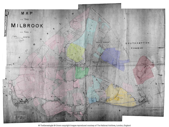
Using the Tithe Apportionment map of the Parish of Millbrook, Hampshire, as a base, I have colour washed some of the plot landowners. The Freemantle and Banister Estates, pale orange and brown respectively can be clearly seen. The landowners in 1843 where Lady Hewitt and Reverend William Fitzhugh. Shirley Park, owned by William Henry Roe, is in green. Blightmont Lodge, occupied by Lady Lisle, just north of Millbrook Road, and part of the larger Berrywood estate owned by Nathaniel Newman Jefferys is shown in a slightly darker blue than the light blue of the rest of the estate. It appears that Nathaniel Newman Jefferys has bought a large swath of the newly released Shirley Common land in the area of Shirley Warren. Clement Hoare & William Dunn seem to have also taken advantage of the inclosue of Shirley and Nutshalling Commons, as joint owners of plots coloured lime green. Roads such as Warren Avenue, Warren Crescent and Tremona Road have already been laid out for the impending urbanisation. However, the biggest landholding in the Parish, by a long way, is Sir John Barker Mill and various associates who together are landowners of the pink coloured plots, mainly farmland in 1843, but destined to be developed and absorbed as suburbs of Southampton.
Introduction and Conclusion
Introduction and Conclusion
Greenwood's Hampshire 1826 section 53
Moving into the current, the Church of England has a database of interesting statistics about all the Parishes in the country. Below is the Map which covers the original Millbrook Parish and shows the current Parishes of;
Millbrook: Holy Trinity
Freemantle: Christ Church (1851)
Shirley: St James (1836)
Maybush.
Click on the parish to bring up the statistics.
The Parish of Millbrook Tithe Map 1843 including Shirley, Freemantle and Four Posts, layered onto Google Earth Pro and Geolocated. Same base map as the coloured ownership map. Over 20 separate tiles or files to fit spherical base globe of Google Earth. All adjusted to best fit the projection, and align roads and as many details as possible. Below is just an image of the result. Google Earth Pro is desktop based so does not lend itself to sharing. However, using transparency of the layers I can locate buildings on the tithe map and see what is there now. I can also use the Lat and Lon and show on Google Maps to georeferenced individual buildings or plots.
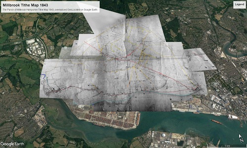
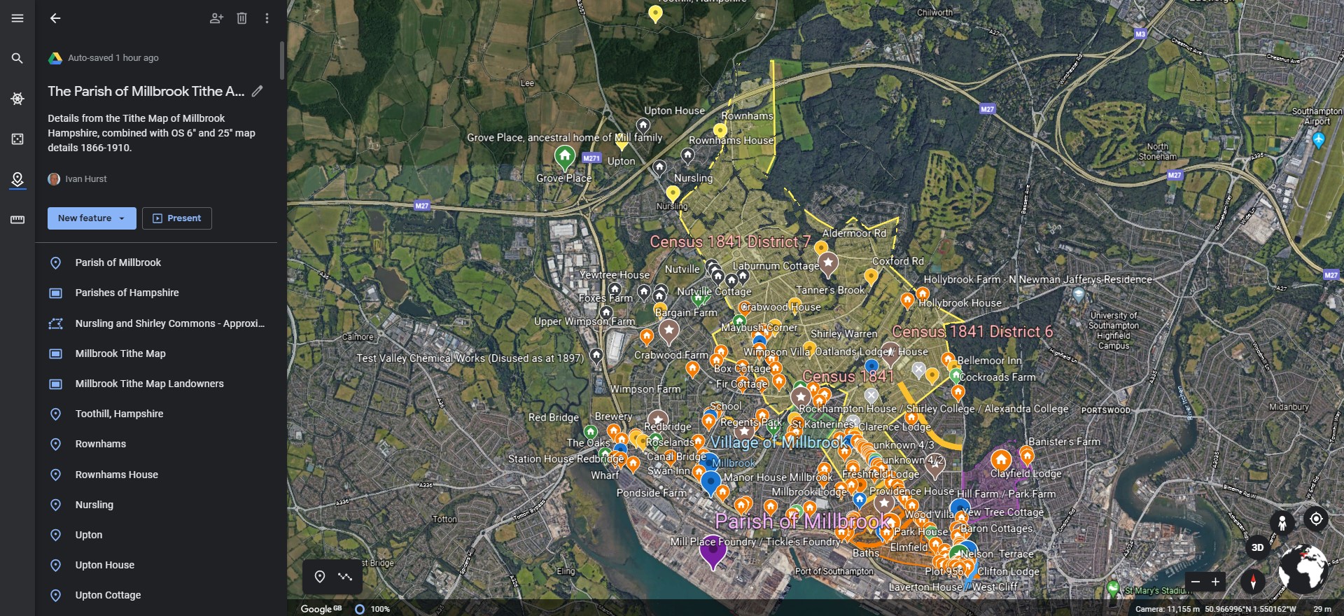
The interactive version is created using a Project in Google Earth and can be seen here, The Parish of Millbrook Tithe Apportionment. Using the Tithe Map plotted on Google Earth Pro above and other maps, I have placed some of the Property names onto a Google Earth Project with an up to date backdrop. History mapped to now.
A screenshot as at March 2020. Work ongoing.
Notes
Notes
Extract from the British Newspaper Archive. Link to source but subscription required.
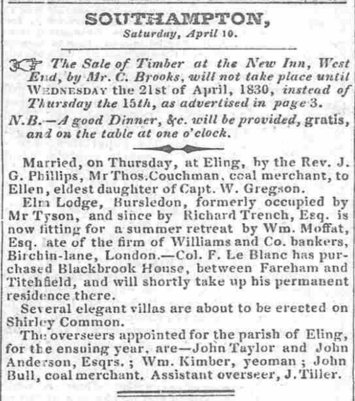
SOUTHAMPTON, Saturday, April 10. The Sale of Timber the New Inn, West JSr.d, by Air. C. Brooks, will not take place until Wednesday the 21st of April, 1830, instead of Thursday the 15th, as advertised in page 3. j N.B. good Dinner, Sfc. will be provided, gratis, and on the table at one o'clock. Married, on Thursday, at Eling, by tbe Rev. J. G. Phillips, MrThos.Couchman, coal merchant, to Ellen, eldest daughter of Capt. W. Gregson. Elm Lodge, Bursledon, formerly occupied by Mr Tyson, and since by Richard Trench, Esq. now fitting for a summer retreat by Wm. Moffat, Esq. ate of the firm of Williams and Co. bankers, Birchin-lane, London.—Col. F. Le Blanc has purchased Blackbrook House, between Fareham and Titehfield, and will shortly take up his permanent residence there. Several elegant villas are about to be erected on Shirley Common. Tht: overseers appointed for the parish of Eling, for tbe ensuing year, are—Jolin Taylor and John Anderson, Esqrs. Wm. Kimber, yeoman John Bull, coal merchant. Assistant overseer, J.Tiller.
Several elegant villas are about to be erected on Shirley Common.
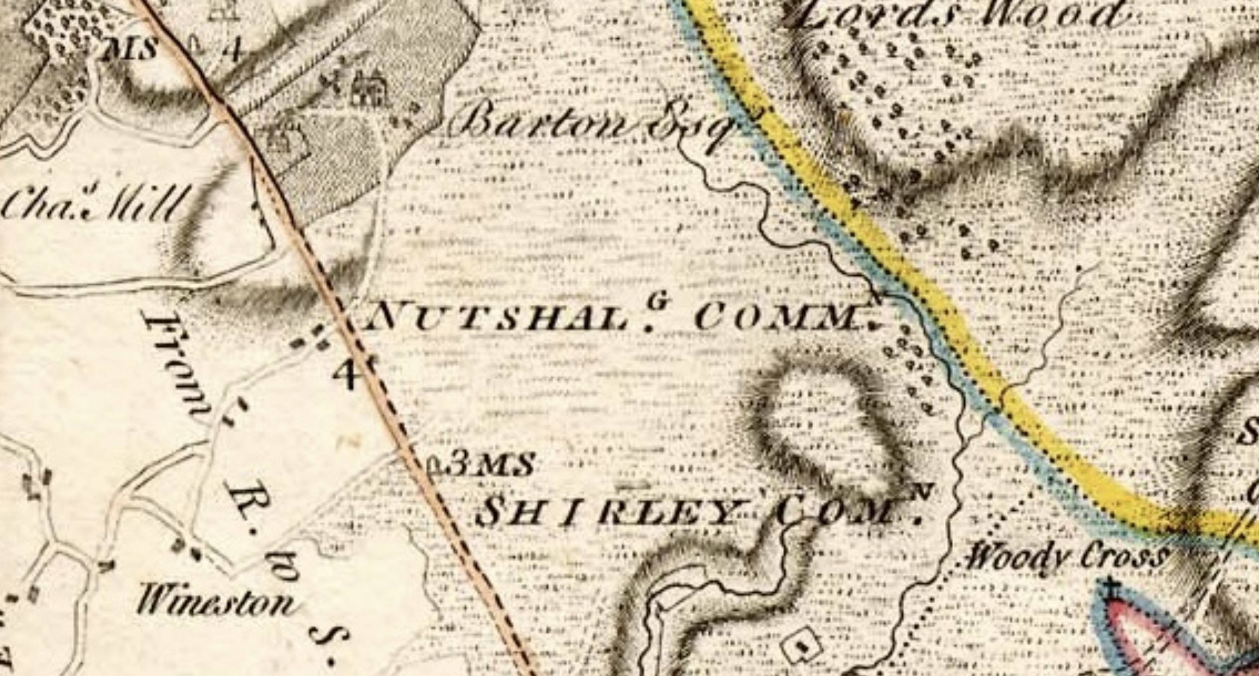
Thought to be Plots 760 to 776 as shown on the Tithe Apportionment Map, in the Tithing of Hill and Sidford. Built on the Romsey Turnpike, later to become Shirley Road, the A3057. In the vicinity of the Rising Sun Public House, probably of the same date.
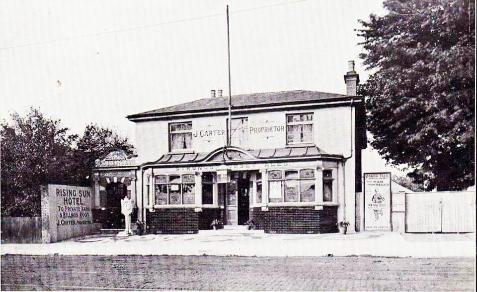
The Rising Sun public house in Shirley Road, now renamed The Brass Monkey. It opened in 1830, it's postal address was Shirley Common and it was a quiet country wayside inn. In this photo, it is called 'Rising Sun Hotel', J. Carter is the proprietor and Strong's of Romsey is the Brewery.
Transcription
Transcription
The Agreement is first transcribed into the Excel spreadsheet as part of the process of collating the data.
| APPORTIONMENT of the RENT-CHARGE in lieu of TITHES in the | Parish | of | Millbrook |
| in the | County | of | Southampton |
| Whereas an Agreement for COMMUTATION of TITHES in the | Parish | of | Millbrook |
| in the | County | of | Southampton |
| was, on the fourth Day of March in the Year One Thousand Eight Hundred and Forty three, | 4th March 1843 | ||
| confirmed by the Tithe Commissioners for England and Wales, of which Agreement, with the Schedules thereunto annexed, the following is a Copy :-- |
|
Articles of Agreement
|
| for the Commutation of the Tithes of the Parish of Millbrook in the County of Southampton in pursuance of the Act for the Commutation of Tithes in England and Wales made executed at a Meeting duly called and holden in the said Parish and adjourned from time to time and holden by Adjournment on the thirty first day of May in the year of our Lord One thousand eight hundred and forty two By and Between the Several Persons Owners of Land within the said Parish by whom or by whose Agents |
| duly authorised in that behalf these presents are executed and the interest of which Land Owners in the said Parish is not less than two thirds of the Lands therein subject to Tithes of the one part |
| The Reverend William Joseph George Phillips |
| who as Rector of the said Parish of the said Parish is Owner of a portion of the Tithes as well Great as Small thereof arising from forty six acres two roods and one perch of Titheable Lands which are setforth in the Second Schedule hereunder written and are |
| situate and being in the Tithing of Hill and Sidford in the said parish and |
| Sir Charles Henry Rich |
| now of Francfort on Maine Baronet Owner of another portion of the Tithes consisting of all the Tithes as well Great as Small arising from all the titheable lands in the said Tithing of Hill and Sidford excepting only all the Tithes of the before mentioned forty six acres two roods and one perch of land and also excepting all the Tithes as well as Great as Small arising from the Tithable lands of the said Tyithing of Hill and Sidford which are setforth in |
| the third fourth fitth and sixth Schedules hereunder written and are therein particularly described and |
| Sir John Barker Mill |
| of Mottisfont Abbey in the said County of Southampton Baronet Owner of the remaining portion of the Tithes as well great as small of the said parish consisting of all the Tithes arising from the titheable lands of the said Tything of Hill and Sidford which are setforth in the third fourth fifth and sixth Schedules hereunder written and are therein particularly described of the other part |
| Whereas |
| the said |
| Sir John Barker Mill |
| is seized in possession of an Estate for life with remainder to his Children in tail of all the Tithes of the lands ??? ??? particularly specified and described in the said third schedule hereunder written and is also seized in possession of an Estate for life with remainder to his children in tail of and in the said lands |
| Now |
| he the said |
| Sir John Barker Mill |
| Doth hereby declare it to his Will and Intent certified by his signature and seal hereunder annexed that the said Tithes as well great as small of the said lands shall henceforth be absolutely merged and extinguished in the freehold and inheritance of the said Lands. |
| It is |
| hereby agreed that the sum of Five hundred and fifty pounds by way of Rent Charge subject to the provisions of the said Acts shall be paid to the said |
| William Joseph George Phillips as Rector |
| of the said Parish and to his Successors instead of all the tithes as well great as small and all moduses and compositions real and prescriptive and customary payments payable to the said Rector in respect of the tithable lands of the said Parish or the produce thereof (except the customary payment of the sum of Five pounds hereinafter mentioned) and also including the tithe of Glebe the rent charge in lieu of which it is hereby agreed shall be fixed at the sum of six shillings in respect of all the tithes as well great as small of all the glebe lands of the said Parish which Glebe land belongs to the said |
| William Joseph George Phillips |
| and consists of three roods and thirty three perches and which item it is hereby agreed shall be apportioned exclusively upon the said Glede lands |
| And it is |
| hereby further agreed that the annual sum of Two hundred and fifty six pounds ten shillings by way of rent charge subject as afordsaid and also charged with the payment thereout of the entire provision or stipend amounting to the sum of Four pounds annually to the Rector of the said Parish for the time being which sum hash been customarily paid by the Lay Impropriator of the tithes of the Tythings of Hill and Sidfoord in the said Parish shall be paid to the said |
| Sir Charles Henry Rich |
| and his assigns during his life and after his decease to the person or persons who for the time being shall be entitled to the same instead of all those tithes of which the said |
| Sir Charles Henry Rich |
| is Owner as aforesaid and all Moduses and Compositions real and prescriptive and customary payments payable to him in respect of any of the titheable lands of the said Parish or the produce thereof |
| And it is |
| hereby further agreed that the annual sum of Thirteen pounds seven shillings and six pence by way of rent charge subject to the provisions of the said Act shall be paid to the said |
| Sir John Barker Mill |
| and his assigns during his life and after his decease to the person or persons who for the time being shall be entitled to the same instead of all those tithes as well great as small and all moduses and compositions real and prescriptive and customary payments payable to him or them in respect of the titheable lands of the said Parish or the produce thereof which lands are respectively set forth and particularly described in the said fourth fith and sixth schedules to those Presents |
| And it is |
| hereby lastly agreed that the lands of the said Parish shall be discharged from the payment of tithes as well great as small except as is excepted by the said Act from the first day of October which shall happen next before the Confirmation of the Apportionment of the said rent charges and that the first payment of such rent charges shall be made or be recoverable on the expiration of Six calendar months from the time from which the said lands are discharged from the payment of tithes |
| In testimony |
| whereof the said parties to these Presents or their respective Agents thereunto duly authorized in their names and on their behalf have to these Presents subscribed and set their respective hands and seals. |
| The |
| whole Parish of Millbrook aforesaid contains two thousand nine hundred and forty seven acres two roods and eighteen perches of land statute measure |
| The |
| whole of which lands except those lands the tithes arising from which are hereinafter declared be excepted are subject to the payment of tithe |
| The |
| whole quantity of land within the said Parish which is at present cultivated as arable land is One thousand five hundred and fifty seven acres and twenty six perches Statute Measure |
| The |
| whole quantity of land within the said Parish which is at present cultivated as meadow or pasture land is Six hundred and thirty acres two roods and thirty eight perches statute measure |
| The |
| whole quantity of land within the said Parish at present forming the sites of houses and roads and consisting of homesteads wood lands and commons or wastes is Four hundred and eight acres three roods and thirty three perches statute measure |
| The |
| under mentioned lands of the said Parish set forth in the first schedule to these Presents are exempt form the payment of all tithes as well Great as Small discharged therefrom by presumption of law |
Dataset
The Dataset
The dataset comprises all of the transcribed information from the Tithe Apportionment and Maps together with additional information, including, inter alia, geolocation and census data. All held in an Excel Spreadsheet. The data is both analysed within the spreadsheet and formed into reports for export as csv files to populate the StoryMap data.
Primary Data
Primary Data
Pending population
Detailed Data - Summary
Detailed Data - Summary
Pending population
Detailed Data - Landowner and Occupier Summary
Detailed Data - Landowner and Occupier Summary
Pending population
Detailed Data - Schedule
Detailed Data - Schedule
Pending population
Land Usage
Graph of Land Usage in Whiteparish in 1842 from the Tithe Apportionment information.
Analysis of the land usage based on the Tithe Apportionment information, showing the primary use as arable at 61%, and secondary usages of woodland 18% and pasture 16%. Common and Furze land has been reduced to about 1%, presumably as a result of the Inclosure Acts, (Enclosure).
Land Ownership
Graph of Land Ownership in Whiteparish in 1842 from the Tithe Apportionment information.
Land Ownership is more widely distributed than in some parishes that I have looked at.
Scroll right to see the list of landowners associated to the graph.
Plot register
The Table with all the data of the Detailed Plot register.
This table has the Landowners and Occupiers of all the Plots in the Parish, including the Description or Names of the plots together with the State of Cultivation. It instances where there is no entry, but it is evident what the Land Usage is I have added the category surrounded with { Brace Brackets }. Not relative to the Tithe Apportionment as some of the Land Usage is not part of the charge regime, however {Residence), {Premises} and {Retail} etc are useful additions. There are approximately 220 Mansions, Houses, or Cottages etc, across the Parish.
The areas of each plot together with the Rentcharge amount in respect of both the Small and Great Tithe, for the Vicar and Impropriator.
Top Ten Landowners
Top Ten Landowners in Whiteparish from the Tithe Apportionment information
From this analysis of the plot level detail for the Parish of Whiteparish the Top Ten Landowners own 91% of the whole recorded area of the parish. Two of the Landowners were relations to the Nelson of The Battle of Trafalgar fame.
Horatio Nelson, 3rd Earl Nelson, (7 August 1823 – 25 February 1913), was 16 years 9 months 7 days at the recorded data of the survey, 14th May 1840, a Minor, hence the Guardians of ...
He was the son of Thomas Bolton (a nephew of Vice Admiral The 1st Viscount Nelson) by his wife Frances Elizabeth Eyre. On 28 February 1835 his father inherited the title Earl Nelson from William Nelson, 1st Earl Nelson and adopted the surname of Nelson. He died on 1 November that year, and his son Horatio succeeded to the title and the estate, Trafalgar House in Wiltshire, in the nearby parish of Downton. The Eyre Family were the owners of Brickworth Park according to the Turnpike Acts for the Whiteparish Romsey Southampton Road. The Dowager Countess Frances Elizabeth Nelson was recorded as being the Landowner as Brickworth Park.
The remainder are either titled or referred to as Esquire. Although not all of the Esquires are in the top ten.
Spare
Spare
Pending population
Spare
Spare
Pending population
more later