


A Study of the Parish of Millbrook, Hampshire
My Millbrook Parish one place study The beginning was actually just a restart triggered by a post in the Facebook group of Guild of One-Name Studies by Karen Heenan-Davies on 7 August 2018.
'I want to do analysis and maps of the BMD and census records to show how my surname Heenan changed geographically over time'
Well that got me thinking about how I had started plotting the Enumerators route of the 1841 Census of Millbrook. It was very rural then.
Link that to thoughts of GIS and BIM, and I join the conversation.
Later that day I start a new Google Map of Millbrook and using the Census images on Ancestry I start plotting the routes and key named places. I also start a spreadsheet which will expand the data extracted from the Census and also provide the upload to ESRI for the interactive ARCGIS Mapping.
Nearly a decade later and the spreadsheet has grown into a suite of integrated spreadsheets, shill growing, and becoming more complex as well as a having a wealth of historical data.
The technical approach has also changed significantly. The system is now firmly based on data. Data is used to populate ESRI StoryMaps directly with Geolocated information directly placed on the map layers. No longer, individual points placed on Google Earth or Google Maps. No more colour washing a map to indicate primary ownership. All done electronically. A separate spreadsheet for Census and another for Tithe has not been replaced entirely, but they are not integrated into a suite of spreadsheets which interact, either directly or via Power Query, for a much more robust and informative system. The derived data is fed into ESRI and here, but no longer as embedded Excel as Microsoft has depreciated that function, if not fully cancelled it. Therefore I will have to look into alternative presentation methods.
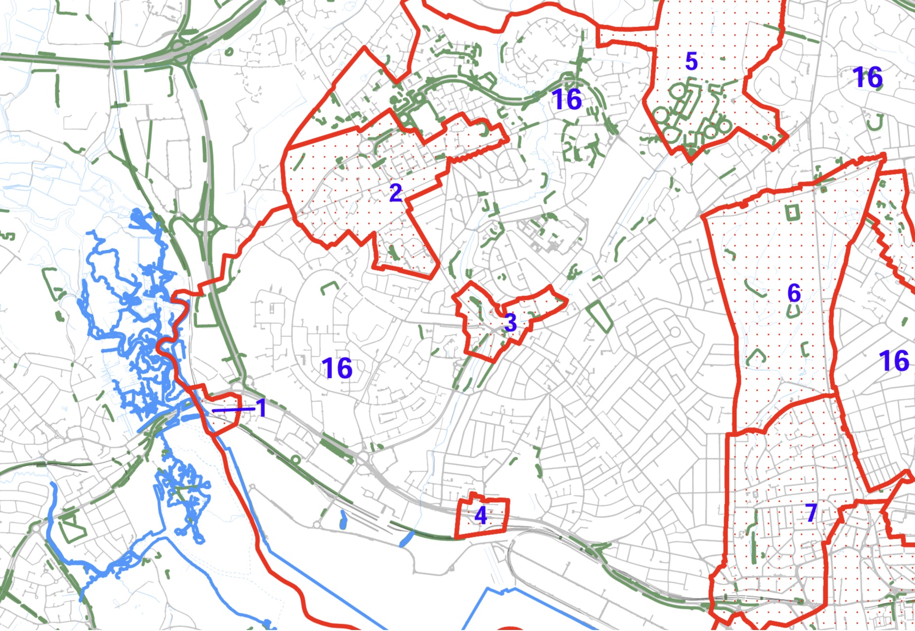
Millbrook village at least stayed within the historical County of Hampshire for the span of this story, but was in the administrative Hundred of Mansbridge, Waltham, Redbridge, Buddlesgate or Buddles Gate, the town of Southampton, and the City of Southampton. A complicated history for a static place.
This is becoming a very large article, and may take a while to load.
OPS Introduction
One place study - studies
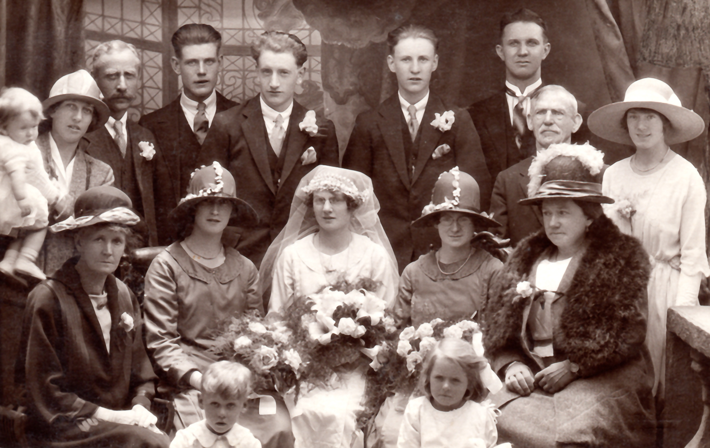
My interest in one place studies started with the 1841 census at Millbrook Hampshire. According to MyHeritage there are only 3496 records for 1841, which increased to 12,863 for the 1891 census. Millbrook, Redbridge, and Nursling were all adjacent rural communities with very low density populations. I have been following the enumerators described roues to try to establish residences and plot them on a map. Communities were fairly static in the early part of the census taking period before WWI. There had been the earlier mass migrations caused by the industrial and agricultural revolutions, exasperated by the enclosure laws. I am expecting to find some families stay in close proximity to the first census and have a tendency to marry the girl/boy next door. Well, near neighbours. By studying one census location from 1841 to 1911, I hope to be able to shed some light on he social change as the population again starts to migrate again and the area becomes urbanised and absorbed into Southampton.
However, before the first, Millbrook, was complete, others popped along, that needed a similar treatment.
This is a collation of them as they currently stand.
Millbrook Parish one place study
One Place Study' of Whiteparish
Clarification of Scope
The are lots of complications regarding the concept of place. Millbrook, Hampshire for instance is a Manor, a village, a parish, and a suburb of Southampton. A study can not reasonably be expected to be all things to all people, all at the same time. Hence we need to set a Scope whilst recognising the boundaries move.
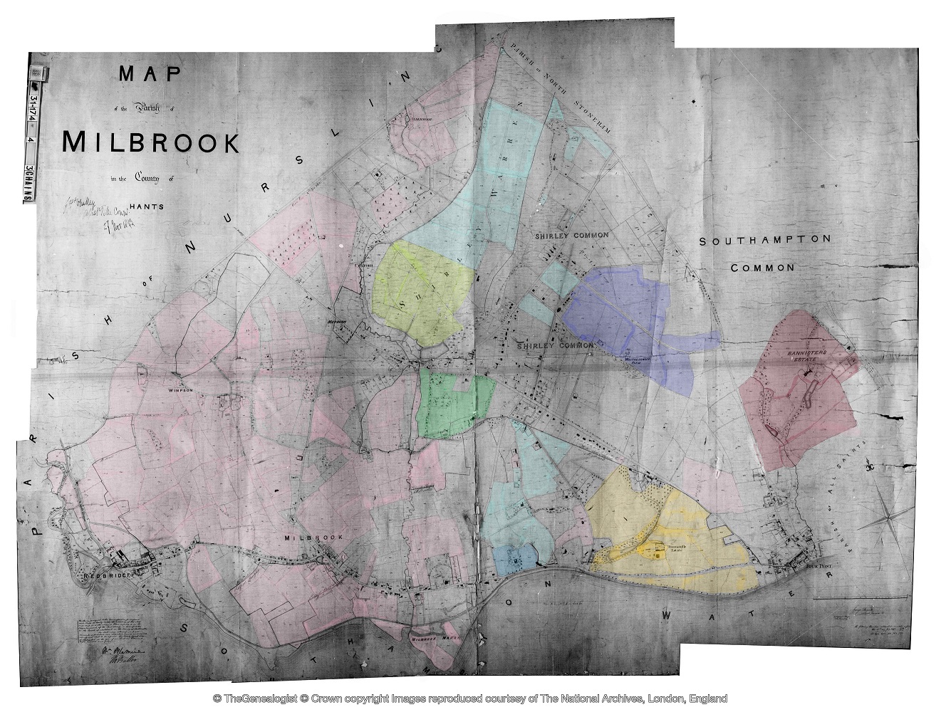
For our purposes, as a generalisation, the Tithe Apportionment Maps represent a good starting point. It is a well defined area with clear boundaries. It probably includes the Ecclesiastical Parish named together with any relevant Extra Parochial area. It is a stable well defined foundation in a point in time. It is not confused with Civil Parishes as they were not created until later.
This is not to ignore the time before the Tithe Apportionment, but to use it as an anchor for both forward looking and past.
Fortunately, the ancient parishes were very stable entities so it is relatively easy to project spatially backwards, with known boundary changes delt with by exception.
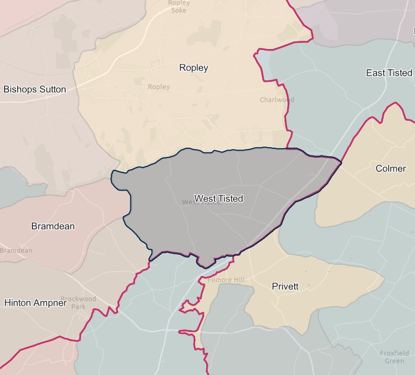
So the concept of the place of Millbrook for the One Place Study of Millbrook is defined by the Millbrook Tithe Apportionment Map and that is broadly static. Therefore the future fluctuations and splits all come into the scope, including Shirley, Freemantle, and Maybush, etc.
The same principle applies to the other Studies listed above. If I need to create a different interpretation I will either come back here or explain it in the particular Study..
more later
Recently added history
Recently added
A recent addition list, for the article. A new table, so not a full version history.
| Date | Description | |
|---|---|---|
| 17 May 2026 | Complete publication of Timeline generated by excel Spreadsheet. All engines within Excel are proved and working correctly | |
| 7 May 2026 | Restructure to reflect Family History suite of spreadsheets' Timeline grouping | |
| 18 April 2026 | Added Condensed Excel generated Parish Register and Timeline in overview | |
| 16 April 2026 | Added an ESRI Domesday interactive map | Completed |
| 14 April 2026 | Restructured the layout of the article creating groups of accordions by subject | Completed |
| 13 April 2026 | Added a section for Research and Archaeology | |
| April 2026 | Populated Domesday Book period | Completed |
| 12 April 2026 | Revised Overview to include Story Map and separated into three parts | On going |
| 12 April 2026 | Updated the opening section before the read-more | |
| April 2026 | Added the OPS introduction above and this section | Completed |
| Mar 2026 | Added a section for Millbrook Manor having found a reference to an Anglo-Saxon Charter 956 | |
| Nov 25 - May 2026 | Working on integrating a suite of spreadsheets for Tithe, Census, Post Office, and other data, with particular emphasis on Geolocation | |
| Article commencement |
Note, Completed in this context, does not mean that something will never be re-visited, just that the with regard to the extent envisaged with the current about of information, it can be parked, and moved on to the next part.
Research and Archaeology
Research and Archaeology
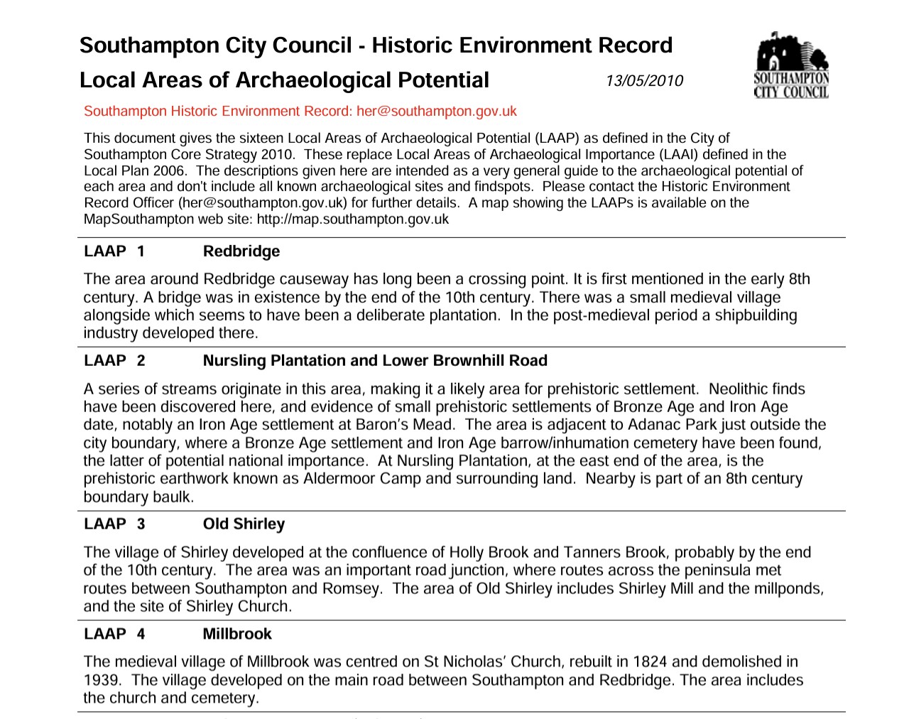
Below, a transcript of parts of the Southampton City Council LAAP.
This document gives the sixteen Local Areas of Archaeological Potential (LAAP) as defined in the City of Southampton Core Strategy 2010. These replace Local Areas of Archaeological Importance (LAAI) defined in the Local Plan 2006. The descriptions given here are intended as a very general guide to the archaeological potential of each area and don't include all known archaeological sites and findspots. Please contact the Historic Environment Record Officer (
LAAP 1 Redbridge The area around Redbridge causeway has long been a crossing point. It is first mentioned in the early 8th century. A bridge was in existence by the end of the 10th century. There was a small medieval village alongside which seems to have been a deliberate plantation. In the post-medieval period a shipbuilding industry developed there.
LAAP 2 Nursling Plantation and Lower Brownhill Road A series of streams originate in this area, making it a likely area for prehistoric settlement. Neolithic finds have been discovered here, and evidence of small prehistoric settlements of Bronze Age and Iron Age date, notably an Iron Age settlement at Baron’s Mead. The area is adjacent to Adanac Park just outside the city boundary, where a Bronze Age settlement and Iron Age barrow/inhumation cemetery have been found, the latter of potential national importance. At Nursling Plantation, at the east end of the area, is the prehistoric earthwork known as Aldermoor Camp and surrounding land. Nearby is part of an 8th century boundary baulk.
LAAP 3 Old Shirley The village of Shirley developed at the confluence of Holly Brook and Tanners Brook, probably by the end of the 10th century. The area was an important road junction, where routes across the peninsula met routes between Southampton and Romsey. The area of Old Shirley includes Shirley Mill and the millponds, and the site of Shirley Church.
LAAP 4 Millbrook The medieval village of Millbrook was centred on St Nicholas’ Church, rebuilt in 1824 and demolished in 1939. The village developed on the main road between Southampton and Redbridge. The area includes the church and cemetery.
LAAP 7 Bannister's Park Prehistoric occupation evidence has been found across much of the area. Roman occupation evidence has been found around the Magistrates Court development in London Road/Inner Avenue and in Archers Road. In the Middle Ages this was a suburban area used for agriculture. Of interest in this respect are the farm of Bannister's Park and the village of Hill. Also included are Conduit Head, Conduit House, the medieval route and clay mine of Rockstone Lane, the medieval marker at Blackberry Mount and the site of the unfinished 18th century Polygon. The rest of Hill Lane appears in this area, as well as parts of the Avenue and all of the Inner Avenue. The Rollesbrook flows through the area, draining southwards from the Common to the Test Estuary. Near the south end of Rollesbrook is the site of Archard’s or Acorn Bridge, perhaps the bridge on the road between medieval Southampton and Redbridge.
LAAP 15 Netley Common This area is part of a Bronze Age barrow cemetery that extends beyond the city boundary. There are three known barrow sites inside the city boundary. The Roman road betweeen Bitterne Manor and Chichester crosses the area.
 An extract of Southampton CC LAAP areas
A useful Aerial Archaeology Mapping Explorer from Historic England. Not showing the Percy Road excavation yet, but too important a site to forget.
Timeline
Timeline
Timeline Focus
Social, Economic, and Migration History from 0 AD to current
NB Social, in this instance, includes major religious.
Not particularly focused on Kings and Queens, inventions, science, wars, celebrities.
Also administrative areas
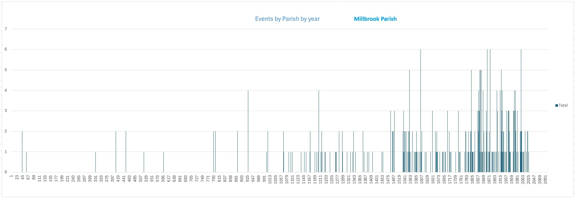
The graph shows lots of white space, low density of events included in the timeline, on the left, and a much higher density of events, or change, on the right hand side.
A complex combination of low historical information, low and relatively static population, and low instance of the changes of interest recorded, albeit lots of wars and occupations, on the left hand side.
To hopefully avoid confusion, or at least dilute it a little. For this context, the Parish of Millbrook refers to the scoop of land described as Millbrook on the appropriate Tithe Apportionment Map. The Parish was stable in size and name for some considerable time before that as well. After the creation of Civil Parishes, there were separations, mergers, and abolitions within the timeline. To provide a constant the base parish remains the same, even though the actual Parish fluctuates. The Timeline therefor captures the events pertaining to daughter parishes, etc.
This is not a normal timeline. Firstly, the years in the title row are generated out of the change events. A change has a year, which creates a column. Also it is a slice of time timeline, not a sequential one, For each year in which there is a column, the text states all that is still relevant for that year, not just the event of that year.
Accordingly, it is more suited to looking up what applied in a particular period, than a long line sequence.
Roman Britain
2 Roman Britain (43–410)
The Roman occupation of Britain introduced urban centres, roads, administration, and written records, integrating the province into the wider Roman world.
Events in this period are drawn from a mixture of Roman historical accounts, archaeology, and later interpretation; local detail is uneven and often indirect.
Total events: 5 for the Parish of Millbrook
Earliest event: 43 Latest event: 410
2 entity types represented; 1 categories represented
These 5 events account for approximately 1.3 percent of the Millbrook parish timeline (5 of 376 events).
| Date | 43 | Category | Historical | Entity | National | Century | 1th |
|---|
Roman invation of England
The Roman invasion was led by Emperor Claudius
| Date | 43 | Category | Historical | Entity | National | Century | 1th |
|---|
Roman occupation
| Date | 60 | Category | Historical | Entity | National | Century | 1th |
|---|
Boudicca, queen of a tribe in east England, fought the Romans.
Over 2 years they destroyed 3 cities, until she was captured.
| Date | 330 | Category | Historical | Entity | World | Century | 4th |
|---|
Byzantine Empire
The Byzantine Empire, also known as the Eastern Roman Empire, was a continuation of the Roman Empire centered on Constantinople from AD 330 to 1453, blending Roman governance with Greek culture and Christianity. Origins and Foundation The Byzantine Empire originated in AD 330 when Emperor Constantine I established Constantinople on the site of the ancient Greek city of Byzantium, creating a “New Rome” that would serve as the capital of the Eastern Roman Empire. Unlike the Western Roman Empire, which fell in AD 476, the Eastern Empire survived for nearly a millennium, preserving Roman administrative structures while gradually adopting Greek language and culture.
| Date | 410 | Category | Historical | Entity | National | Century | 5th |
|---|
Roman troops left
Celtic kingdoms reappear alongside Roman culture.
Early Medieval
3 Early Medieval (411–899)
A transitional period following the end of Roman rule, marked by shifting kingdoms, cultural change, and the gradual spread of Christianity.
Documentary evidence is sparse and often retrospective; dates are frequently approximate and events tend to reflect political or ecclesiastical developments rather than everyday life.
Total events: 8 for the Parish of Millbrook
Earliest event: 449 Latest event: 886
2 entity types represented; 1 categories represented
These 8 events account for approximately 2.1 percent of the Millbrook parish timeline (8 of 376 events).
| Date | 449 | Category | Historical | Entity | National | Century | 5th |
|---|
Anglo-Saxons intergartion
| Date | 449 | Category | Historical | Entity | National | Century | 5th |
|---|
Anglo-Saxons invaded
Tribes from areas in Germany, the Netherlands and Denmark gradually moved into Britain. They were known as the Anglo-Saxons. The Celtic people were pushed to Wales, Cornwall, Devon, Somerset, Cumbria and Scotland. But by about 800, Cornwall, Devon and Somerset were part of the Anglo-Saxon kingdom of Wessex.
| Date | 519 | Category | Historical | Entity | National | Century | 6th |
|---|
Kingdom of the West Saxons, aka Kingdom of Wessex
| Date | 597 | Category | Historical | Entity | National | Century | 6th |
|---|
Christianity became popular in Anglo-Saxon kingdoms
| Date | 793 | Category | Historical | Entity | National | Century | 8th |
|---|
Vikings from Scandinavia arrived
Within 100 years the Vikings controlled much of central and north-eastern England, an area called the Danelaw.
| Date | 793 | Category | Historical | Entity | National | Century | 8th |
|---|
Vikings occupied the Northen part of England
| Date | 800 | Category | Historical | Entity | World | Century | 8th |
|---|
Holy Roman Empire
The Holy Roman Empire was a complex, decentralized European polity that existed from 800 (or 962) to 1806, centered on Germany and claiming continuity with the ancient Roman Empire. Origins and Early History The Holy Roman Empire traces its roots to Charlemagne, King of the Franks, who was crowned Emperor of the Romans by Pope Leo III on 25 December 800, reviving the imperial title more than three centuries after the fall of the Western Roman Empire in 476. After Charlemagne’s death, the empire fragmented, and the imperial title lapsed until 962, when Otto I of Saxony was crowned emperor by Pope John XII, marking the formal beginning of the Holy Roman Empire as a German-centered polity. The empire initially included Germany, Italy, and Burgundy, though over time its effective control over Italy and Burgundy diminished.
| Date | 886 | Category | Historical | Entity | National | Century | 9th |
|---|
Alfred the Great adopted the title 'King of the Anglo-Saxons'
High Medieval
4 High Medieval (900–1349)
A period of growing stability and expansion following the Norman Conquest, marked by the consolidation of feudal lordship, the development of manorial and parish structures, and the increasing influence of the Church.
Records for this era become more regular but are still selective, focusing on landholding, lordship, and the Church rather than the wider population.
Total events: 48 for the Parish of Millbrook
Earliest event: 927 Latest event: 1348
4 entity types represented; 6 categories represented
These 48 events account for approximately 12.8 percent of the Millbrook parish timeline (48 of 376 events).
| Date | 927 | Category | Historical | Entity | National | Century | 10th |
|---|
Æthelstan conquered the Danish kingdoms and adopted the title 'King of the English'
Æthelstan conquered the Danish kingdoms, and when Æthelstan conquered the last surviving one, York he adopted the title 'King of the English'
| Date | 927 | Category | Historical | Entity | National | Century | 10th |
|---|
England as a Kingdom
| Date | 927 | Category | Historical | Entity | National | Century | 10th |
|---|
England created
| Date | 1000 | Category | Infrastructure | Entity | County | Century | 10th |
|---|
Redbridge Crossing
Causeway/crossing at Redbridge from Roman period. Key crossing point of River Test on route from Clausentum.
| Date | 1005 | Category | Historical | Entity | National | Century | 11th |
|---|
Scotland as a Kingdom
| Date | 1005 | Category | Historical | Entity | National | Century | 11th |
|---|
Scotland united
Rival northern Celtic groups formed one nation, Scotland.
| Date | 1066 | Category | Historical | Entity | National | Century | 11th |
|---|
England and France under one crown
The Norman Conquest of England in 1066 led to the establishment of a unified monarchy under the rule of William the Conqueror. This period saw the integration of England and France, with William's rule linking England to continental affairs and influencing the development of the English monarchy. The conquest resulted in the subordination of England to a Norman aristocracy, with William distributing estates to his followers and building castles to control his new kingdom. The Domesday Book, completed by 1086, was a significant record of the Great Survey of much of England and parts of Wales, reflecting the changes brought by the conquest.
| Date | 1066 | Category | Military | Entity | National | Century | 11th |
|---|
William, Duke of Normandy, invades England
The beginning of the Norman period of rule of England
| Date | 1067 | Category | Military | Entity | National | Century | 11th |
|---|
Castle capital of the world
Wales is often referred to as the "castle capital of the world," boasting over 600 castles, with around 427 still standing today, showcasing a rich history and architectural diversity. Wales has a long and tumultuous history, particularly following the Battle of Hastings in 1066, when William the Conqueror granted lands to his supporters, leading to the construction of numerous castles. These fortifications were built primarily by English lords to exert control over the Welsh territories, resulting in a landscape dotted with impressive military architecture.
| Date | 1086 | Category | Historical | Entity | Parish | Century | 11th |
|---|
Parish name attested as "Melebroc" / "Melebroche"
Domesday Book forms
| Date | 1086 | Category | Historical | Entity | Parish | Century | 11th |
|---|
Domesday Entry - Melebroc aka Melebroche
Meaning: “Mill stream / brook with a mill” Hundred: Redbridge Notes: Millbrook was recorded as a manor associated with the Redbridge area, later forming part of the parish structure you now have. Identification is secure.
| Date | 1086 | Category | Administrative | Entity | Parish | Century | 11th |
|---|
Within Redbridge Hundred
Hundred jurisdiction
| Date | 1086 | Category | Administrative | Entity | National | Century | 11th |
|---|
The Great Survey of England - Domesday Book
Survey of England to establish land ownership and usage for taxation
| Date | 1095 | Category | Historical | Entity | World | Century | 11th |
|---|
The First Crusade
1095: Pope Urban II calls for the First Crusade at the Council of Clermont, urging Christians to reclaim Jerusalem and aid the Byzantine Empire against Muslim advances 1096: The People’s Crusade, led by Peter the Hermit, departs for Constantinople but is largely destroyed by Seljuk forces. 1096–1099: The First Crusade, led by nobles such as Godfrey of Bouillon and Raymond of Toulouse, captures key cities including Nicaea, Antioch, and Jerusalem, establishing Crusader states like the Kingdom of Jerusalem. 1101: The Crusade of 1101, an early follow-up expedition, ends in defeat.
| Date | 1100 | Category | Historical | Entity | County | Century | 11th |
|---|
County referred to as Southamptonshire
Medieval usage of county name derived from Southampton (Hamtun); overlapped with Hants/Hampshire
| Date | 1135 | Category | Historical | Entity | National | Century | 12th |
|---|
The Anarchy
After King Henry I died, there was a brutal civil war for 19 years. This was because two people wanted the English crown: Henry’s daughter Matilda, and his nephew Stephen of Blois. Eventually Stephen won.
| Date | 1147 | Category | Historical | Entity | World | Century | 12th |
|---|
The Second Crusade
1147–1149: The Second Crusade is launched in response to the fall of Edessa but fails to achieve its objectives
| Date | 1169 | Category | Historical | Entity | National | Century | 12th |
|---|
England invaded Ireland
England invaded Ireland under the instruction of the Pope, to spread Christianity. The Norman invasion of Ireland began to establish English possessions in Ireland, with thousands of English and Welsh settlers arriving in Ireland. English control mostly was resigned to an area of Ireland known as The Pale, most of Ireland, large swaths of Munster, Ulster and Connaught remained independent of English rule until the Tudor and Stuart periods. (Hence "Beyond the Pale")
| Date | 1171 | Category | Historical | Entity | National | Century | 12th |
|---|
England / Britain rulled Ireland
England ruled the island of Ireland for over 700 years. Although there was some mixing of the English and Irish populations, mostly they lived side by side.
| Date | 1189 | Category | Historical | Entity | World | Century | 12th |
|---|
The Third Crusade
1189–1192: The Third Crusade, led by Richard the Lionheart, Philip II of France, and Frederick I Barbarossa, partially succeeds in defending Crusader states, though Jerusalem remains under Muslim control after Saladin’s victories.
| Date | 1196 | Category | Historical | Entity | World | Century | 12th |
|---|
The Mongol Empire
The largest contiguous empire the world has ever seen, the Mongol Empire stretched from Europe in the west to the Sea of Japan in the east, and from the Arctic Circle down to the Indian subcontinent. The empire reached its greatest extent in 1279 when Kublai Khan completed the conquest of China. By that time the Mongols' famously efficient messenger-riders, who could supposedly cover around 200 miles (322km) a day, would take more than a month to travel from one end of the empire to the other. The sudden rise of the Mongols began when a warlord named Temujin united the nomadic tribes of the Mongolian Plateau and took on a new name: Genghis Khan. His military supremacy came thanks to his extremely mobile armies staffed by mounted warriors who were deadly with bows and arrows. Enemies that did not submit were put down with extreme brutality, and the Mongols' ruthless reputation soon preceded them. Many smaller kingdoms chose to surrender rather than face the might of the Mongol horde. The Mongol Empire began to fracture after the death of its fourth Great Khan, Mongke, in 1259. Different factions vied for control, and, although Genghis' grandson Kublai technically ruled as Great Khan until his death in 1294, the empire was already coming apart. The empire would never again unite under a single ruler, and Karakorum, the grand capital of the Mongol Empire for just 50 years, soon fell into disrepair. It is now the site of Erdene Zuu Monastery (pictured) in central Mongolia.
| Date | 1200 | Category | Historical | Entity | Parish | Century | 12th |
|---|
Parish name variant "Melebrook"
Medieval spelling variation
| Date | 1202 | Category | Historical | Entity | World | Century | 13th |
|---|
The Fourth Crusade
1202–1204: The Fourth Crusade, initially aimed at Egypt, is diverted to Constantinople, resulting in the Sack of Constantinople and the establishment of the Latin Empire.
| Date | 1204 | Category | Historical | Entity | National | Century | 13th |
|---|
Treaty of Paris
After the Norman Conquest of England in 1066, the relationship between England and France became increasingly complex. The Anglo-Norman realm was established, but by the 13th century, tensions led to the dissolution of the Anglo-Norman alliance, culminating in the Treaty of Paris in 1204, which marked the end of English control over Normandy and the beginning of a permanent breach between the two nations.
| Date | 1204 | Category | Historical | Entity | World | Century | 13th |
|---|
Latin Empire
The Latin Empire was a Crusader state established in Constantinople in 1204, lasting until 1261, formed after the Fourth Crusade captured Byzantine territories. Origins and Foundation The Latin Empire, also known as the Latin Empire of Constantinople or Imperium Romaniae, was established by leaders of the Fourth Crusade on lands taken from the Byzantine Empire. Originally, the Crusade aimed to reclaim Jerusalem, but political and economic factors, including Venetian influence, diverted the army to Constantinople. In April 1204, the Crusaders captured and plundered the city, installing a Catholic emperor in place of the Eastern Orthodox Byzantine rulers, with Baldwin IX of Flanders crowned as Baldwin I on 16 May 1204.
| Date | 1212 | Category | Historical | Entity | World | Century | 13th |
|---|
The Children's Crusade
1212: The Children’s Crusade occurs, a largely unsuccessful popular movement of young people attempting to reach the Holy Land.
| Date | 1215 | Category | Historical | Entity | National | Century | 13th |
|---|
King John forced to sign the Magna Carta
King John was a bad king. His lords became angry and made him sign a document (the Magna Carta) that said he must follow the rules of England. It also limited how much the lords could be taxed and gave ‘free men’ the right to a fair trial. This idea of human rights was copied across the world.
| Date | 1215 | Category | Legislation | Entity | National | Century | 13th |
|---|
Magna Carta continus to impact Society
Ongoing effect of the Magna Carta
| Date | 1217 | Category | Historical | Entity | World | Century | 13th |
|---|
The Fifth Crusade
1217–1221: The Fifth Crusade targets Egypt but fails to secure lasting gains.
| Date | 1228 | Category | Historical | Entity | World | Century | 13th |
|---|
The Sixth Crusade
1228–1229: The Sixth Crusade, led by Holy Roman Emperor Frederick II, achieves a diplomatic agreement to regain Jerusalem temporarily without major battles.
| Date | 1248 | Category | Historical | Entity | World | Century | 13th |
|---|
The Seventh Crusade
1248–1254: The Seventh Crusade, led by Louis IX of France, focuses on Egypt but ends in failure.
| Date | 1270 | Category | Historical | Entity | World | Century | 13th |
|---|
The Eighth Crusade
1270: The Eighth Crusade, also led by Louis IX, targets Tunis and concludes with his death, marking the end of major Crusading efforts in the Holy Land.
| Date | 1271 | Category | Historical | Entity | World | Century | 13th |
|---|
Italian Explorers and Their Discoveries
Famous Italian Explorers and Their Discoveries The Italian explorers listed above have made significant contributions to the world through their adventurous journeys and discoveries. Here are some of their notable achievements: Marco Polo: His travels along the Silk Road in the 13th century provided Europeans with detailed accounts of Asian civilizations, influencing subsequent expeditions. Christopher Columbus: His 1492 transatlantic voyage to the Americas initiated sustained European contact with the Americas, establishing naval routes that enabled colonization and resource extraction. Amerigo Vespucci: His voyages in the early 1500s revealed that the lands along the eastern coast of South America were a distinct continent, separate from Asia, and his letters prompted cartographers to name the region "America" in his honor. John Cabot: His exploration of parts of the North American continent while sailing for England demonstrated viable northwest passages for fishing and trade. Giovanni da Verrazzano: His exploration of the North American coast from the Carolinas to Newfoundland in 1524 produced the first European descriptions of New York Harbor and confirmed the presence of a substantial landmass blocking direct Asian access. These explorers' contributions have had a lasting impact on history, connecting cultures, and expanding our understanding of the world. Their stories serve as a reminder of the importance of curiosity, ambition, and a strong sense of adventure in shaping our world.
| Date | 1273 | Category | Historical | Entity | World | Century | 13th |
|---|
Austrian (Habsburg) Empire
Austrian (Habsburg) Empire: A European continental empire with diverse populations across Austria, Bohemia, Hungary, and parts of Italy and Belgium, governed under a complex system of dynastic and regional authority.
| Date | 1284 | Category | Historical | Entity | National | Century | 13th |
|---|
England ruled Wales
| Date | 1284 | Category | Historical | Entity | National | Century | 13th |
|---|
England took control of Wales
King Edward I fought Welsh prince Llywelyn ap Gruffudd and he was killed in 1282. In 1284, the Statute of Rhuddlan made Wales part of England.
| Date | 1295 | Category | Electoral | Entity | Parish | Century | 13th |
|---|
Parish within Southampton Parliamentary Borough
Borough franchise prior to reform; limited electorate
| Date | 1296 | Category | Historical | Entity | National | Century | 13th |
|---|
Edward I invaded Scotland.
Edward I of England invaded Scotland
| Date | 1297 | Category | Historical | Entity | National | Century | 13th |
|---|
Scot William Wallace tried to fight the English
William Wallace tried to fight the English to free Scotland from English rule.
| Date | 1314 | Category | Historical | Entity | National | Century | 14th |
|---|
Battle of Bannockburn
Scottish king Robert the Bruce defeated the English at the Battle of Bannockburn
| Date | 1315 | Category | Historical | Entity | National | Century | 14th |
|---|
The Great Famine
The Great Famine. Over 7 years, at least 10% of people across Britain died from starvation caused by 2 years of very bad weather.
| Date | 1328 | Category | Historical | Entity | National | Century | 14th |
|---|
Scotland became independent in 1328.
| Date | 1337 | Category | Historical | Entity | National | Century | 14th |
|---|
The Hundred Years’ War
It started when King Edward III of England tried to invade France. 116 years later, France won.
| Date | 1338 | Category | Historical | Entity | Parish | Century | 14th |
|---|
French raid on Southampton impacts Millbrook parish
Raid on Southampton during early Hundred Years’ War affected surrounding parishes; loss of property and disruption beyond town walls
| Date | 1338 | Category | Historical | Entity | Parish | Century | 14th |
|---|
Construction and strengthening of Southampton town walls affects adjacent parishes
Defensive works following French raid required labour, materials, and resources from surrounding parishes including Millbrook
| Date | 1340 | Category | Historical | Entity | National | Century | 14th |
|---|
British monarchy continue to claim the French crown, and use it in their style
| Date | 1340 | Category | Historical | Entity | National | Century | 14th |
|---|
Edward III formalises his claim to the Frence Crown
Edward III delivered to Pope Benedict XII a document setting out the legal case justifying his claim. This was expanded upon in a more detailed legal brief used at a peace conference in 1344 presided over by Benedict's successor, Clement VI, at the papal palace at Avignon.
| Date | 1348 | Category | Historical | Entity | National | Century | 14th |
|---|
The Black Death
Bubonic plague killed 40% of people in one year. Many villages disappeared. But because of a labour shortage, the remaining peasants could suddenly choose who to work for and what to do. There was big social change.
Late Medieval
5 Late Medieval (1350–1539)
Shaped by the aftermath of the Black Death, social change, and increasing tension between traditional structures and emerging early modern institutions.
Surviving records are more varied but uneven; many entries relate to taxation, land, or ecclesiastical matters, with gaps reflecting record loss or local circumstance.
Total events: 25 for the Parish of Millbrook
Earliest event: 1377 Latest event: 1538
5 entity types represented; 6 categories represented
These 25 events account for approximately 6.6 percent of the Millbrook parish timeline (25 of 376 events).
| Date | 1377 | Category | Military | Entity | County | Century | 14th |
|---|
French Raid on Isle of Wight and South Coast
French raids on the South Coast including Isle of Wight
| Date | 1377 | Category | Military | Entity | Regional | Century | 14th |
|---|
French Raid on Isle of Wight and South Coast
French raids on the South Coast including Isle of Wight
| Date | 1381 | Category | Social | Entity | National | Century | 14th |
|---|
The Peasants’ Revolt
Thousands of peasants protested in London because they wanted equal rights and did not want to pay a new tax. Eventually wool exports were taxed instead.
| Date | 1394 | Category | Historical | Entity | World | Century | 14th |
|---|
Portuguese Age of Discovery
Portugal produced many influential explorers during the Age of Discovery, including Vasco da Gama, Bartolomeu Dias, Ferdinand Magellan, and Prince Henry the Navigator. Key Portuguese Explorers and Their Achievements Prince Henry the Navigator (1394–1460): Initiated Portugal’s Age of Discovery, sponsored expeditions along the West African coast, and helped establish navigation schools that advanced maritime knowledge. Bartolomeu Dias (c. 1450–1500): First European to sail around the southern tip of Africa, the Cape of Good Hope, opening the sea route to Asia. Vasco da Gama (1469–1524): First European to reach India by sea, establishing a direct maritime trade route between Europe and Asia. Pedro Álvares Cabral (c. 1467–1520): Credited with the discovery of Brazil for Portugal in 1500 and led expeditions to India. Ferdinand Magellan (1480–1521): Led the first expedition to circumnavigate the globe, although he died during the voyage; his expedition proved the world could be circumnavigated by sea. Diogo Cão (c. 1452–1486): Explored the Congo River and the west coast of Africa, establishing early Portuguese presence in the region. Pêro da Covilhã (c. 1460–c. 1526): Traveled overland to Africa and India, gathering intelligence that aided Portuguese maritime expeditions. Diogo Dias (c. 1470–c. 1500): Participated in early Indian Ocean voyages and was among the first Europeans to circumnavigate the globe. João Gonçalves Zarco (c. 1390–1471): Discovered and helped colonize the Madeira Islands, contributing to Portugal’s Atlantic expansion. Tristão da Cunha (c. 1460–1540): Explored the South Atlantic and discovered the islands later named after him, enhancing Portuguese navigation knowledge. These explorers collectively expanded geographical knowledge, established trade routes, and laid the foundations for Portugal’s global maritime empire. Their voyages connected Europe with Africa, Asia, and the Americas, influencing commerce, culture, and the spread of Christianity during the 15th and 16th centuries. For a more extensive list, including lesser-known navigators, historical records identify 37 notable Portuguese explorers, reflecting Portugal’s significant role in global exploration during the Renaissance.
| Date | 1400 | Category | Administrative | Entity | Parish | Century | 14th |
|---|
Ancient of parish of Millbrook
early-modern parish formed from surrounding ancient parish lands,Parish registers | Continues as EP: Ecclesiastical parish continues into post-separation period with established parish records
| Date | 1400 | Category | Social | Entity | National | Century | 14th |
|---|
The Welsh Revolt
The Welsh Revolt: a member of the Welsh royalty, Owain Glyndwr, led the Welsh to revolt against the new English king, Henry IV. At first it seemed like he was successful, but eventually the English took back control.
| Date | 1415 | Category | Historical | Entity | World | Century | 15th |
|---|
Portuguese Empire
The Portuguese Empire existed from 1415 to 1999. It began with the capture of Ceuta in 1415 and lasted until the handover of Macau to China in 1999. During this period, it became one of the largest and longest-lived empires in world history, controlling vast territories across the Americas, Africa, and Asia.
| Date | 1451 | Category | Historical | Entity | World | Century | 15th |
|---|
Spanish Explorers and Their Contributions
Spain produced many influential explorers who expanded its empire across the Americas and beyond, including Hernán Cortés, Francisco Pizarro, and Christopher Columbus. Key Spanish Explorers and Their Contributions Christopher Columbus (1451–1506) – Italian-born navigator who sailed for Spain, credited with opening the Americas to European exploration and colonization. Hernán Cortés (1485–1547) – Conqueror of the Aztec Empire in Mexico, establishing Spanish dominance in the region. Francisco Pizarro (1478–1541) – Led the conquest of the Inca Empire in Peru, securing vast wealth for Spain. Juan Ponce de León (1460?–1521) – Explored Florida and sought the legendary Fountain of Youth. Hernando de Soto (1500–1542) – Explored the southeastern United States, including the Mississippi River. Vasco Núñez de Balboa (1475?–1519) – First European to see the Pacific Ocean from the Americas. Ferdinand Magellan (1480–1521) – Initiated the first circumnavigation of the globe, though he died during the voyage. Pedro de Alvarado (1485–1541) – Conquered parts of Central America, including Guatemala. Cabeza de Vaca (1490?–1558?) – Explored the Gulf Coast and southwestern United States, documenting indigenous cultures. Juan de Oñate (1550?–1626) – Led expeditions into present-day New Mexico, establishing Spanish settlements. Panfilo de Narvaez (1478?–1528) – Explored Florida and the Gulf Coast, though his expedition ended in disaster. Diego de Almagro (1475–1538) – Partnered with Pizarro in the conquest of Peru and explored Chile. Francisco Vázquez de Coronado (1510–1554) – Explored the southwestern United States in search of the Seven Cities of Gold. Pedro Menéndez de Avilés (1519–1574) – Founded St. Augustine, Florida, the oldest European settlement in the continental U.S.. Juan Rodríguez Cabrillo (1499?–1543) – Explored the California coast, claiming it for Spain. Estevanico (1500?–1539) – African explorer who traveled across the American Southwest with Spanish expeditions. Father Eusebio Francisco Kino (1645–1711) – Missionary and explorer in the Pimería Alta region (modern Arizona and Sonora),. Captain Juan Bautista de Anza II (1736–1788) – Led expeditions from Mexico to California, establishing routes for settlers. Lucas Vázquez de Ayllón (1475–1526) – Explored the southeastern United States and attempted early colonization. Fray Marcos de Niza (1495?–1558) – Explored the American Southwest, reporting on the fabled cities of Cíbola. These explorers collectively expanded Spain’s territorial claims, established settlements, and documented indigenous cultures, leaving a lasting impact on the Americas and global navigation. Their voyages were driven by the pursuit of wealth, glory, and the spread of Christianity, shaping the course of world history.
| Date | 1455 | Category | Historical | Entity | National | Century | 15th |
|---|
The Wars of the Roses.
When King Henry VI became too ill to rule, Richard, Duke of York was asked to take over temporarily. However, he didn’t want to stop being ruler even when the king was better. This started a 30-year war between two sides of the English royal Plantagenet family: the House of York (which had a white rose logo) and the House of Lancaster (red rose logo).
| Date | 1485 | Category | Historical | Entity | National | Century | 15th |
|---|
The start of the Tudor dynasty.
Henry Tudor of the House of Lancaster won the Battle of Bosworth Field and became King Henry VII. To stop the fighting of the previous 30 years, he married his rival’s niece, Elizabeth of York. Henry then created the House of Tudor (with a red and white rose logo). England and Wales entered a time of relative peace and growing wealth.
| Date | 1485 | Category | Historical | Entity | National | Century | 15th |
|---|
Tudor dynasty.
The Tudor monarchs were descended from the House of Lancaster. They ruled the Kingdom of England and the Lordship of Ireland (later the Kingdom of Ireland) for 118 years with five monarchs: Henry VII, Henry VIII, Edward VI, Mary I and Elizabeth I.
| Date | 1485 | Category | Historical | Entity | World | Century | 15th |
|---|
French Explorers and Their Discoveries
French explorers played a pivotal role in mapping the world, discovering new lands, and establishing colonies, particularly in North America, the Caribbean, Africa, and Asia. Notable French Explorers and Their Discoveries Jacques Cartier (1491–1557) Cartier explored the Gulf of St. Lawrence and the St. Lawrence River in present-day Canada. He made three voyages between 1534 and 1542, establishing French claims in North America and laying the groundwork for the colony of New France, including Quebec City. Samuel de Champlain (1567–1635) Known as the "Father of New France," Champlain explored the Atlantic coast, the St. Lawrence River, and parts of the Great Lakes. He founded Quebec City in 1608 and mapped much of northeastern North America. Giovanni da Verrazzano (1485–1528) Although Italian-born, Verrazzano sailed under the French flag in 1524, exploring the Atlantic coast of North America from Florida to Newfoundland in search of a western route to Asia. René-Robert Cavelier, Sieur de La Salle (1643–1687) La Salle explored the Mississippi River basin, claiming the entire Mississippi Valley for France and naming it Louisiana in honor of King Louis XIV. André Michaux (1746–1802) A botanist and explorer, Michaux studied North American flora extensively, collecting specimens across the United States and contributing to botanical knowledge with works like Histoire des chênes de l'Amérique and Flora Boreali-Americana. Jules Dumont d’Urville (1790–1842) D’Urville explored the Pacific, including parts of Antarctica, and contributed to mapping and scientific studies of the region. Henri Duveyrier (1840–1892) Duveyrier explored the Sahara Desert, documenting Tuareg culture and geography, and contributed to European knowledge of North African deserts. Jacques-Yves Cousteau (1910–1997) Although primarily a 20th-century explorer, Cousteau revolutionized oceanography, exploring the world’s oceans and developing scuba technology. Summary French explorers were instrumental in expanding European knowledge of the globe, particularly in North America, the Caribbean, Africa, and the Pacific. Their discoveries included rivers, coastlines, and territories, as well as contributions to science, botany, and cartography. These explorations often led to the establishment of colonies and trade networks, shaping global history.
| Date | 1492 | Category | Historical | Entity | World | Century | 15th |
|---|
Spanish Empire
The Spanish Empire was a global colonial power from 1492 to 1976, spanning Europe, the Americas, Africa, Asia, and Oceania, and became one of the largest empires in history. Origins and Expansion The Spanish Empire began with the unification of Castile and Aragon under Ferdinand II and Isabella I, culminating in the completion of the Reconquista in 1492 and the sponsorship of Christopher Columbus’s voyage to the Americas. Spain rapidly expanded across the Caribbean, Central and South America, and parts of North America, toppling the Aztec and Inca civilizations and establishing colonies that would become the foundation of its vast empire. The Treaty of Tordesillas (1494) divided the world between Spain and Portugal, securing Spanish claims in the New World. Peak and Global Influence At its height in the late 18th and early 19th centuries, the Spanish Empire covered 13.7 million square kilometers, earning the reputation as "the empire on which the sun never sets". Wealth from silver and gold mines in Mexico and Bolivia financed military campaigns and European wars, while Spain dominated maritime trade across the Atlantic and Pacific. The empire’s administration relied on viceroys and local councils to govern its extensive territories, and the Manila galleons facilitated trade between Asia and the Americas. Cultural and Economic Impact Spain experienced a Golden Age in the 16th and 17th centuries, marked by flourishing arts, literature, and architecture, supported by wealth from the colonies. The empire also influenced global culture, language, and religion, spreading Catholicism and creating enduring cultural links across continents. However, the empire’s expansion often involved exploitation and forced labor systems, such as the encomienda and repartimiento, which affected indigenous populations. Decline and Legacy The Spanish Empire began to decline due to weak leadership, costly wars, economic troubles, and the Habsburgs’ dynastic issues. Territorial losses in Europe and the eventual independence of most American colonies by the 19th century marked the end of Spain’s global dominance, though it retained some territories in Africa and the Asia-Pacific until the mid-20th century. Despite its decline, the Spanish Empire left a lasting legacy in language, culture, law, and global trade networks, shaping the modern world.
| Date | 1492 | Category | Exploration and Colonisation | Entity | World | Century | 15th |
|---|
The voyages of Christopher Columbus began
The voyages of Christopher Columbus began in 1492, sailing west into the unknown with hopes of reaching Asia. He sighted land in the West Indies on 12 October that year, and in 1493 returned to colonize one of the islands he mistook for "the Indies" and named the indigenous peoples "Indians".
| Date | 1493 | Category | Historical | Entity | World | Century | 15th |
|---|
Spain in the Americas
Spain established a vast colonial presence in North America, shaping its culture, governance, and economy from the 16th century onward. Spanish Exploration and Colonization Spain’s involvement in North America began after Christopher Columbus’s voyages in 1492, with formal colonization starting in 1493 on Hispaniola (modern Haiti and the Dominican Republic) under the Crown of Castile. Spanish explorers and conquistadors expanded into the mainland, conquering the Aztec Empire in 1519–1521 and establishing control over Mexico, Central America, and the southern regions of what is now the United States, including Florida, Texas, Arizona, New Mexico, and California. These territories were collectively known as New Spain, with Mexico City serving as the administrative and cultural hub. Geographic Extent Spain’s North American empire extended from the Caribbean and Mexico northward into the southern United States, including Florida, Texas, New Mexico, Arizona, and California. While some regions were sparsely settled, Spain maintained control through missions, forts, and alliances with Indigenous groups. Spanish claims were eventually challenged by other European powers, but the cultural and architectural legacy remains prominent in these areas. The last Spanish territory in North America was Florida, which Spain claimed until 1763. After that, it was ceded to England in the Treaty of Paris. Additionally, Spain had claimed territories in the region, including parts of present-day Florida, Georgia, and parts of Texas, but these were lost to other powers after the American Revolutionary War. Peru was the last territory on the continent under Spanish rule, which ended on 9 December 1824 at the Battle of Ayacucho (Spanish rule continued until 1898 in Cuba and Puerto Rico).
| Date | 1497 | Category | Exploration and Colonisation | Entity | National | Century | 15th |
|---|
John Cabot finds Newfoundland
John Cabot (Italian: Giovanni Caboto c. 1450 – c. 1499) was an Italian navigator and explorer. His 1497 voyage to the coast of North America under the commission of Henry VII, King of England is the earliest known European exploration of coastal North America since the Norse visits to Vinland in the eleventh century. To mark the celebration of the 500th anniversary of Cabot's expedition, both the Canadian and British governments declared Cape Bonavista, Newfoundland as representing Cabot's first landing site. However, alternative locations have also been proposed.
| Date | 1497 | Category | Historical | Entity | World | Century | 15th |
|---|
British Empire
The British Empire was the largest empire in history, spanning continents and influencing global politics, trade, culture, and law for over three centuries. Origins and Early Expansion The British Empire began in the late 16th and early 17th centuries with England establishing overseas trading posts and settlements, inspired by the wealth generated by Spanish and Portuguese exploration. Early expeditions included John Cabot’s 1497 voyage to Newfoundland and the establishment of colonies in North America and the West Indies during the 17th century. The East India Company, founded in 1600, marked the beginning of British influence in India, while the first permanent African settlement was established on James Island in the Gambia River in 1661. Peak and Global Reach By the 19th and early 20th centuries, the British Empire had become the largest empire in history, covering 35.5 million km² (13.7 million sq mi) and ruling over 412 million people, about 23–25% of the world population at the time. Its territories spanned Africa, Asia, the Americas, and the Pacific, earning it the nickname "the empire on which the sun never sets" because daylight always shone on at least one of its colonies. Key acquisitions included Jamaica, Canada, Australia, New Zealand, and strategic trading posts in India, Southeast Asia, and Africa. Economic and Cultural Impact The Empire’s power was built on trade, maritime dominance, and resource extraction. It facilitated global commerce, industrialization in Britain, and the spread of British legal, political, and educational systems. Cultural legacies include the widespread use of the English language, sports like cricket and football, and legal frameworks still influential in former colonies. However, the Empire also involved exploitation of indigenous populations, forced labor, and economic inequalities. Decline and Legacy The decline of the British Empire accelerated in the 20th century due to rising nationalism in colonies, economic pressures, and global conflicts. Ghana (formerly the Gold Coast) became the first sub-Saharan African colony to gain independence in 1957, and Hong Kong was the last significant colony returned to China in 1997. Today, the British Empire no longer exists, but its legacy continues through the Commonwealth of Nations, a voluntary association of former colonies and the United Kingdom, recognizing the British monarch as a symbolic head.
| Date | 1500 | Category | Historical | Entity | Parish | Century | 15th |
|---|
Parish name standardised as "Millbrook"
Modern standard form
| Date | 1500 | Category | Historical | Entity | County | Century | 15th |
|---|
County formally styled County of Southampton
Early‑modern legal and administrative usage; name persisted alongside Hampshire
| Date | 1534 | Category | Legislation | Entity | National | Century | 16th |
|---|
The Reformation. Act of Supremacy
The Reformation. Henry VIII declared himself Supreme Head of the Church of England. Separation from Rome. Catholic King Henry VIII wanted to divorce his wife because she had not had a son. But divorce was forbidden by the Pope. So Henry made himself the head of a new church, the Church of England (Protestant). This led to many years of Catholic-Protestant fighting. Henry VIII is famous now for having six wives. He also executed over 50,000 people.
| Date | 1534 | Category | Historical | Entity | National | Century | 16th |
|---|
The Church of England
Henry VIII made himself the head of a new church, the Church of England (Protestant).
| Date | 1535 | Category | Legislation | Entity | National | Century | 16th |
|---|
Wales incorporated into England
Wales was formally incorporated into England through the Laws in Wales Acts of 1535–1542.
| Date | 1536 | Category | Legislation | Entity | National | Century | 16th |
|---|
Dissolution of the Monasteries
Dissolution of monasteries under Henry VIII. Major transfer of church property to Crown and nobility.
| Date | 1536 | Category | Historical | Entity | National | Century | 16th |
|---|
England and Wales made a formal union in 1536.
England and Wales made a formal union in 1536.
| Date | 1538 | Category | Legislation | Entity | National | Century | 16th |
|---|
Parish Registers Mandated
Thomas Cromwell's injunction requiring parish churches to keep registers of baptisms, marriages and burials.
Early Modern
6 Early Modern (1540–1699)
A period of religious reform, expanding state administration, and improved record‑keeping, including the introduction of parish registers.
Most events in this era derive from official records such as registers, wills, and legal documents; coverage improves, but interpretation still depends on record survival.
Total events: 55 for the Parish of Millbrook
Earliest event: 1540 Latest event: 1699
4 entity types represented; 9 categories represented
These 55 events account for approximately 14.6 percent of the Millbrook parish timeline (55 of 376 events).
| Date | 1540 | Category | Historical | Entity | National | Century | 16th |
|---|
British Explorers and Their Discoveries
List of British Explorers and Their Discoveries The following provides a brief overview of some of the most notable British explorers and their significant discoveries: Francis Drake 1540 - 1596 Francis Drake was an English explorer and privateer, who was the first Englishman to circumnavigate the world. He is most famous for his raids on Spanish ships and settlements in the Americas. Established trade routes and asserted England's presence globally. Captain James Cook 1728 - 1779 James Cook was a British explorer and navigator who mapped much of the world's coastlines and discovered many islands. He is most famous for leading three expeditions to the Pacific Ocean, during which he claimed the eastern coast of Australia for Britain. Revolutionized navigation and cartography. Sir Richard Francis Burton; Explorations in Asia and the Americas. Known for his extraordinary knowledge of languages and cultures. Sir Martin Frobisher; Made three voyages to the New World. Sighted Resolution Island and entered Frobisher Bay. Robert Falcon Scott 1868 - 1912 Robert Falcon Scott was a British Royal Navy officer and explorer who led two expeditions to the Antarctic, both of which ended in tragedy. On his first expedition, Scott led a party of five which reached the South Pole on 17 January 1912, only to find that they had been preceded by Roald Amundsen's Norwegian expedition. On the second expedition, Scott led a party of four which reached the pole on 17 January 1912, only to find that Amundsen had preceded them again. On their return journey, Scott and his companions all died from a combination of exhaustion, starvation and extreme cold. David Livingstone 1813 - 1873 David Livingstone is most famous for his exploration of the African continent and his discovery of the Victoria Falls. Henry Morton Stanley 1841 - 1904 Henry Morton Stanley is most famous for being the first person to cross Africa from east to west, and for his search for David Livingstone. William Adams 1564 - 1620 William Adams, also known as Miura Anjin, was a navigator and explorer who helped the Tokugawa shogunate establish trade with the Western world. He is most famous for his role in the opening of Japan to the Western world. William Baffin 1584 - 1622 William Baffin is most famous for being the first European to see the Baffin Bay, which he named in 1616. Henry Hudson 1570 - 1611 Henry Hudson is most famous for his discovery and exploration of the Hudson River and Hudson Bay. Opened up North America to European exploration and settlement. John Ross 1777 - 1856 Scottish naval officer and polar explorer. These explorers' contributions to global history, culture, and trade are significant and continue to be celebrated for their pioneering spirit and adventurous spirit.
| Date | 1542 | Category | Ecclesiastical Parish | Entity | Regional | Century | 16th |
|---|
Diocese of Bristol Created
Parts of Dorset transferred to new Diocese of Bristol.
| Date | 1546 | Category | Military | Entity | National | Century | 16th |
|---|
The Royal Navy continues from 1546
| Date | 1546 | Category | Military | Entity | National | Century | 16th |
|---|
The founding of the Royal Navy
The English Royal Navy was formally founded in 1546 by Henry VIII, though the Kingdom of England had possessed less-organised naval forces for centuries prior to this.
| Date | 1550 | Category | Historical | Entity | World | Century | 16th |
|---|
Dutch explorers during the Age of Discovery.
Notable Dutch explorers include Abel Tasman, Willem Barentsz, and Jan van Riebeeck, who made significant contributions to exploration during the Age of Discovery. Key Dutch Explorers Abel Tasman (1603 - 1659): Known for his voyages in the service of the Dutch East India Company (VOC), Tasman was the first European to reach New Zealand in 1642 and is credited with discovering Tasmania, which was named after him. His expeditions aimed to explore uncharted regions of the Southern Pacific Ocean. Willem Barentsz (1550 - 1597): A prominent explorer of the Arctic, Barentsz is best known for his expeditions to find a Northeast Passage to Asia. He discovered several islands in the Arctic, including Spitsbergen and Bear Island, during his voyages in the late 16th century. Jan van Riebeeck (1619 - 1677): He is recognized for founding Cape of Good Hope in 1652, establishing a refreshment station for the VOC. His settlement laid the groundwork for Dutch colonization in South Africa. Cornelis de Houtman (1565 - 1599): He led the first Dutch expedition to the East Indies, which opened up the spice trade for the Netherlands and marked the beginning of Dutch colonial expansion in Asia. François Thijssen (died 1638): An explorer who navigated the southern coast of Australia, contributing to the mapping and understanding of the region during the early 17th century. Jan Carstenszoon (c. 1560 - 1659): He was commissioned by the VOC to explore the southern coast of New Guinea and is known for his expeditions in the early 17th century. These explorers played crucial roles in expanding European knowledge of the world, establishing trade routes, and contributing to the Dutch colonial empire during the Age of Discovery. For a more detailed exploration of their voyages and contributions, you can refer to the sources provided.
| Date | 1554 | Category | Legislation | Entity | National | Century | 16th |
|---|
Repeal of The Act of Supremacy
The Act of Supremacy (which asserted England's independence from papal authority) was repealed in 1554 by Henry's devoutly Catholic daughter Queen Mary I when she reinstituted Catholicism as England's state religion. She executed many Protestants by burning.
| Date | 1555 | Category | Transport | Entity | National | Century | 16th |
|---|
The Highways Act 1555
The Highways Act 1555 was the first English statute to place the responsibility for road maintenance on local parishes, mandating parishioners to contribute labor and resources. In 1555, each parish became legally responsible for the upkeep of the roads in their area. Each householder was required to spend 6 days each year working on the roads, but this was very difficult to enforce and was a great burden on local money and labour. Trading between neighbouring towns suffered due to the bad transport links.
| Date | 1558 | Category | Historical | Entity | National | Century | 16th |
|---|
Elizabethan Religious Settlement.
The Act of Supremacy of 1558 re-established the Church of England’s independence from Rome and gave her the title of Supreme Governor of the Church of England
| Date | 1558 | Category | Historical | Entity | National | Century | 16th |
|---|
Queen Elizabeth I ruled, the Elizabethan Era, the Golden Age
Queen Elizabeth I, the Virgin Queen, rule was a time of great wealth for the country, although many thousands are made homeless because of changes in land use.
| Date | 1559 | Category | Social | Entity | National | Century | 16th |
|---|
English anti-Catholicism
English anti-Catholicism was grounded in the fear that the Pope sought to reimpose not just religio-spiritual authority but also secular power over England, a view which was vindicated by hostile actions of the Vatican. In 1570, Pope Pius V sought to depose Elizabeth with the papal bull Regnans in Excelsis, declaring her a heretic and dissolving Catholics' duty of allegiance to her. This engendered a state of war between the Pope and England, escalating to extended hostilities and culminating in a failed 1588 invasion by Spanish forces. Elizabeth's resultant persecution of Catholic Jesuit missionaries led to many executions at Tyburn. Priests like Edmund Campion who suffered there as traitors to England are considered martyrs by the Catholic Church, and a number of them were canonized as the Forty Martyrs of England and Wales. In the 20th century, a "Shrine of the Martyrs at Tyburn" was established at the Catholic Tyburn Convent in London
| Date | 1559 | Category | Legislation | Entity | National | Century | 16th |
|---|
Act of Uniformity
The Act found a middle ground between Catholicism and Protestantism. The Church of England’s modern doctrinal character is largely the result of this settlement, which sought to negotiate a middle ground between the two branches of Christianity.
| Date | 1559 | Category | Legislation | Entity | National | Century | 16th |
|---|
New Act of Supremacy
Queen Mary I actions were reversed by a new Act of Supremacy passed in 1559 under her successor, Elizabeth I, along with an Act of Uniformity which made worship in Church of England compulsory. Anyone who took office in the English church or government was required to take the Oath of Supremacy; penalties for violating it included hanging and quartering. Attendance at Anglican services became obligatory—those who refused to attend Anglican services, whether Roman Catholics or Puritans, were fined and physically punished as recusants.
| Date | 1559 | Category | Historical | Entity | National | Century | 16th |
|---|
Queen Elizabeth I crowned.
Queen Elizabeth I was the last of the Tudor dydasty. She was a Protestant queen.
| Date | 1565 | Category | Historical | Entity | National | Century | 16th |
|---|
The Royal Exchange
The merchant Thomas Gresham founded the Royal Exchange. It was established as the first purpose-built center for trading stocks in England and officially opened by Queen Elizabeth I on January 23, 1571. It proved to be hugely important in the economic development of England.
| Date | 1570 | Category | Historical | Entity | National | Century | 16th |
|---|
Catholic plots against Queen Elizabeth I
The 1570s and 1580s were dangerous decades for Elizabeth; she faced four big Catholic plots against her. All had the aim of getting the Catholic Mary, Queen of Scots on the throne and returning England to Catholic rule.
| Date | 1570 | Category | Historical | Entity | National | Century | 16th |
|---|
Pope issued a Papal Bull of Excommunication
1570 the Pope issued a Papal Bull of Excommunication against Elizabeth and actively encouraged plots against her.
| Date | 1577 | Category | Exploration and Colonisation | Entity | National | Century | 16th |
|---|
Sir Francis Drake was the first Englishman to circumnavigate the globe.
Sir Francis Drake was the first Englishman to circumnavigate the globe, completing his journey between December 13, 1577, and September 26, 1580. His expedition was authorized by Queen Elizabeth I and involved five ships, with Drake's flagship, the Golden Hind, being the only one to return intact. Drake's circumnavigation was not only a significant achievement in exploration but also a precursor to the Anglo-Spanish War, as he engaged in numerous raids against Spanish interests
| Date | 1581 | Category | Historical | Entity | World | Century | 16th |
|---|
Dutch Empire
The Dutch colonial empire comprised overseas territories and trading posts under some form of Dutch control from the early 17th to late 20th centuries, including those initially administered by Dutch chartered companies—primarily the Dutch East India Company (1602–1799) and Dutch West India Company (1621–1792)—and subsequently governed by the Dutch Republic (1581–1795) and modern Kingdom of the Netherlands (1815–1975). Following the de facto independence of the Dutch Republic from the Spanish Empire in the late 16th century, various trading companies known as voorcompagnie led maritime expeditions overseas in search of commercial opportunities. By 1600, Dutch traders and mariners had penetrated the lucrative Asian spice trade but lacked the capital or manpower to secure or expand their ventures; this prompted the States General in 1602 to consolidate several trading enterprises into the semi-state-owned Dutch East India Company (Dutch: Verenigde Oost-Indische Compagnie, VOC), which was granted a monopoly over Asian trade.
| Date | 1583 | Category | Exploration and Colonisation | Entity | National | Century | 16th |
|---|
Humphrey Gilbert claimed Newfoundland
Humphrey Gilbert, a member of parliament and explorer, claimed Newfoundland for Queen Elizabeth I
| Date | 1585 | Category | Historical | Entity | National | Century | 16th |
|---|
Sir Walter Raleigh, first English colony in America
In August 1585 Sir Walter Raleigh arranged for the first (albeit short-lived) English colony in America at Roanoke. The Roanoke Colony was the site of two attempts by Sir Walter Raleigh to found the first permanent English settlement in North America. The first colony was established at Roanoke Island in 1585 as a military outpost, and was evacuated in 1586. The more famous second colony, known as the Lost Colony, began when a new group of settlers under John White arrived on the island in 1587; a ship in 1590 found the colony abandoned. The fate of the 112 to 121 colonists remains largely unknown.
| Date | 1587 | Category | Historical | Entity | National | Century | 16th |
|---|
The execution of Mary, Queen of Scots
The execution of Mary, Queen of Scots took place on 8 February 1587 at Fotheringhay Castle, Northamptonshire, England. After nineteen years in English captivity following her forced abdication from the throne of Scotland, Mary was found guilty of plotting the assassination of her cousin, Elizabeth I, in what became known as the Babington Plot. The execution of Mary was the first legal execution of an anointed European monarch.
| Date | 1588 | Category | Historical | Entity | National | Century | 16th |
|---|
The Armada
A group of ships from Spain tried to invade England. The Catholic King of Spain wanted to overthrow Elizabeth I and return England to Catholicism. They were defeated by ships and storm.
| Date | 1592 | Category | Historical | Entity | National | Century | 16th |
|---|
Scottish parliament becomes Presbyterian.
This is a type of Protestant Christianity, influenced by the teachings of John Calvin.
| Date | 1598 | Category | Legislation | Entity | National | Century | 16th |
|---|
Parochial Registers Act 1598
Required parish registers to be kept on parchment and copies sent to diocese.
| Date | 1600 | Category | Registration | Entity | Parish | Century | 16th |
|---|
Bishop's Transcripts in use
Annual submission of parish register copies to bishop
| Date | 1600 | Category | Registration | Entity | Parish | Century | 16th |
|---|
Earliest known Bishop's Transcript
Earliest surviving Bishop’s Transcript copy; later parish formation reflected in BT series
| Date | 1603 | Category | Historical | Entity | National | Century | 17th |
|---|
The Crowns of Scotland and England align before formal Union
| Date | 1603 | Category | Historical | Entity | National | Century | 17th |
|---|
The start of the Stuart dynasty. The joining of the Crowns
The start of the Stuart dynasty. King James VI of Scotland was a close relation of the English Queen Elizabeth I. He was crowned as James I of England after her death because she has no children. It brought the two nations together (uneasily).
| Date | 1604 | Category | Historical | Entity | National | Century | 17th |
|---|
Great Brittaine comes into existance
On 20 October 1604, James issued a proclamation at Westminster changing his style to "King of Great Brittaine, France and Ireland, Defender of the Faith, &c."
| Date | 1605 | Category | Historical | Entity | World | Century | 17th |
|---|
First French colonial empire
The French colonial empire consisted of the overseas colonies, protectorates, and mandate territories that came under French rule from the 16th century onward. A distinction is generally made between the "first French colonial empire", that existed until 1814, by which time most of it had been lost or sold, and the "second French colonial empire", which began with the conquest of Algiers in 1830. On the eve of World War I, France's colonial empire was the second-largest in the world after the British Empire. During the 16th century, the French colonization of the Americas began. Excursions of Giovanni da Verrazzano and Jacques Cartier in the early 16th century, as well as the frequent voyages of French boats and fishermen to the Grand Banks off Newfoundland throughout that century, were the precursors to the story of France's colonial expansion. But Spain's defense of its American monopoly, and the further distractions caused in France itself in the later 16th century by the French Wars of Religion, prevented any constant efforts by France to settle colonies. Early French attempts to found colonies in Brazil, in 1555 at Rio de Janeiro ("France Antarctique") and in Florida (including Fort Caroline in 1562), and in 1612 at São Luís ("France Équinoxiale"), were not successful, due to a lack of official interest and to Portuguese and Spanish vigilance. The story of France's colonial empire truly began on 27 July 1605, with the foundation of Port Royal in the colony of Acadia in North America, in what is now Nova Scotia, Canada. A few years later, in 1608, Samuel de Champlain founded Quebec, which was to become the capital of the enormous, but sparsely settled, fur-trading colony of New France (also called Canada).
| Date | 1607 | Category | Exploration and Colonisation | Entity | National | Century | 17th |
|---|
English/British colonies of North America
| Date | 1607 | Category | Exploration and Colonisation | Entity | National | Century | 17th |
|---|
Jamestown Colony in North America founded
Jamestown Colony, first permanent English settlement in North America, located near present-day Williamsburg, Virginia. Established on May 14, 1607
| Date | 1620 | Category | Exploration and Colonisation | Entity | National | Century | 17th |
|---|
Mayflower. New World
Mayflower was an English square-rigged merchant sailing ship, active from before 1609 until 1622. She was 110 feet long and 25 feet in the beam with several decks. She was notable in that she transported a group of English families, known today as the Pilgrims, from England to the New World in 1620. After 10 weeks at sea, Mayflower, with 102 passengers and a crew of about 30, reached what is today the United States, dropping anchor near the tip of Cape Cod, Massachusetts on 21 November [O.S. 11 November] 1620. The Pilgrims, often conflated with the Puritans (who sought to reform and purify the Church of England from within), sought separation from the church and prayed privately. They believed that the church's resistance to reform and its Roman Catholic past left it beyond redemption. Starting in 1608, a group of English families departed England for the Netherlands, where they could worship freely. By 1620, the community resolved to cross the Atlantic Ocean for America, which they considered a "new Promised Land" where they would establish Plymouth Colony.
| Date | 1624 | Category | Historical | Entity | World | Century | 17th |
|---|
French West Indies
As the French empire in North America grew, the French also began to build a smaller but more profitable empire in the West Indies. Settlement along the South American coast in what is today French Guiana began in 1624, and a colony was founded on Saint Kitts in 1625 (the island had to be shared with the English until the Treaty of Utrecht in 1713, when it was ceded outright). The current isle of the Commonwealth of Dominica in the eastern Caribbean also fell under increasing French settlement from the early 1630s. The Compagnie des Îles de l'Amérique founded colonies in Guadeloupe and Martinique in 1635, and a colony was later founded on Saint Lucia by (1650). The food-producing plantations of these colonies were built and sustained through slavery, with the supply of slaves dependent on the African slave trade. Local resistance by the indigenous peoples resulted in the Carib Expulsion of 1660. France's most important Caribbean colonial possession was established in 1664, when the colony of Saint-Domingue (today's Haiti) was founded on the western half of the Spanish island of Hispaniola. In the 18th century, Saint-Domingue grew to be the richest sugar colony in the Caribbean. The eastern half of Hispaniola (today's Dominican Republic) also came under French rule for a short period, after being given to France by Spain in 1795
| Date | 1633 | Category | Ecclesiastical Parish | Entity | Parish | Century | 17th |
|---|
Earliest Known Baptism Record
| Date | 1633 | Category | Ecclesiastical | Entity | Parish | Century | 17th |
|---|
Earliest known burial register
Earliest surviving parish burial record
| Date | 1633 | Category | Ecclesiastical | Entity | Parish | Century | 17th |
|---|
Earliest known marriage register
Earliest surviving parish marriage record
| Date | 1633 | Category | Ecclesiastical Parish | Entity | Parish | Century | 17th |
|---|
Parish Baptism records
| Date | 1633 | Category | Ecclesiastical | Entity | Parish | Century | 17th |
|---|
Parish burial registers
Ongoing parish burial record series
| Date | 1633 | Category | Ecclesiastical | Entity | Parish | Century | 17th |
|---|
Parish marriage registers
Ongoing parish marriage record series
| Date | 1642 | Category | Historical | Entity | National | Century | 17th |
|---|
The English Civil War
King Charles I was not a good leader and wanted money for a war with Scotland. Parliament did not want to help him. People who supported the king (Cavaliers) fought people who supported Parliament (Roundheads). About 10% of the population died in the fighting.
| Date | 1649 | Category | Historical | Entity | National | Century | 17th |
|---|
Britain became a republic (called ‘the Commonwealth’).
King Charles I was executed, had his head cut off at Whitehall. A military leader called Oliver Cromwell took control. He became a dictator.
| Date | 1660 | Category | Historical | Entity | National | Century | 17th |
|---|
The Restoration of the Monarchy.
Cromwell died in 1658 and his son Richard took over. He was not a good leader. Charles I’s son was invited back to the country to be King Charles II.
| Date | 1663 | Category | Transport | Entity | National | Century | 17th |
|---|
The Turnpike Era
By the 16th century, the transport need was mostly met by coasting shipping, e.g. to London from Kings Lynn, Hull and Newcastle. Rivers were also used. In 1600, there were 500 miles of navigable waterways, increasing to 1160 miles by 1720. There was often local opposition to the waterway developments and Acts of parliament were passed to overcome this. Trade increased as result of the improvements. In 1663, tolls were levied on vehicles using a busy section of the Great North Road to supplement local repairs, the first Turnpike Road. This was the only turnpike road until 1696. These turnpike roads were the responsibility of local trusts who collected the tolls. Some of the income was spent on the roads and the remainder was paid out in dividends to the trustees. Each road required an Act of Parliament to permit the levying of tolls. They were basically commercial ventures like canals and attracted the entrepreneurs of the day. Then a series of turnpike Acts was progressively introduced, and there was a boom in the 1720s. By 1750, there were 143 turnpike trusts covering 3386 miles of roads, mostly near London, the Severn Valley and the West Midlands. Most turnpike roads were made after 1750. By 1830, there were 20,000 miles of turnpike roads, producing an annual revenue of £500,000. The better roads and the establishment of stage coaches drastically cut journey times, e.g. London to Bristol in 1750 took 2 days, but only 19 hours by 1785. With the increasing levels of fraud and corruption in a small number of Turnpike trusts as the Victorian era progressed, and the continuing rivalry of the railways making the other trusts increasingly uneconomic, the Government saw fit to act and effectively nationalised the trusts from the 1870s onwards (as they would with the railways in 1948). The responsibility of road maintenance was then passed on to the County and County Borough councils as part of the Local Government Act 1888, who also assumed responsibility of all the other roads that had previously been 'maintained' by other local bodies at that time. In many cases, the councils inherited routes that were far superior to any others in the area, and owing to the nature of the origins of the trusts, these were routes that connected the most important towns and cities. It is therefore hardly surprising that most of these roads would feature again in the 1922 Road Lists, or its B-road equivalent. Even today, there are few rural routes bearing an A- or B classification which have no link to the Turnpike Network of 150 years ago. And, to turn that around, there are few former turnpikes which have never been classified.
| Date | 1665 | Category | Historical | Entity | National | Century | 17th |
|---|
The Great Plague of London
About 20% of London’s population died of bubonic plague.
| Date | 1666 | Category | Legislation | Entity | National | Century | 17th |
|---|
Burial in Woollen Act 1666
Required burial in wool to support English wool trade. Penalties for non-compliance.
| Date | 1666 | Category | Historical | Entity | National | Century | 17th |
|---|
The Great Fire of London
A fire that started in a bakery in Pudding Lane destroyed 80% of the city, but with minimal casualties.
| Date | 1667 | Category | Military | Entity | National | Century | 17th |
|---|
The Dutch raided Chatham Dockyard
The Dutch successfully raided Chatham Dockyard in June 1667, capturing and destroying English ships and delivering one of the worst defeats in Royal Navy history. The Dutch invasion at Chatham occurred during the Second Anglo-Dutch War (1665–1667), a conflict driven by commercial rivalry and naval supremacy between England and the Dutch Republic. England, under King Charles II, faced economic strain, unpaid sailors, and the aftermath of the Great Plague (1665) and the Great Fire of London (1666), leaving the nation vulnerable. The Dutch, led by Lieutenant-Admiral Michiel de Ruyter and politically directed by Johan de Witt, seized this opportunity to strike decisively
| Date | 1668 | Category | Social | Entity | National | Century | 17th |
|---|
The Bawdy House Riots
The Bawdy House Riots (1668): Apprentices in London protested against the presence of brothels in the city, leading to the destruction of several bawdy houses.
| Date | 1678 | Category | Legislation | Entity | National | Century | 17th |
|---|
Burial in Woollen Act 1678
Strengthened requirements for burial in wool. Affidavits required.
| Date | 1688 | Category | Historical | Entity | National | Century | 17th |
|---|
Glorious Revolution
The deposition of King James II in November 1688. He was replaced by his daughter Mary II and her Dutch husband, James's nephew William III of Orange. The two ruled as joint monarchs of England, Scotland, and Ireland until Mary's death in 1694
| Date | 1689 | Category | Historical | Entity | National | Century | 17th |
|---|
The Glorious Revolution
King James II (King Charles II’s brother) was unpopular – and Catholic. He fled abroad after William of Orange (the husband of his Protestant daughter Mary) came with an army. Mary and William became joint monarchs, known as William III and Mary.
| Date | 1692 | Category | Historical | Entity | National | Century | 17th |
|---|
The Glencoe Massacre
Catholics in Scotland were told to swear their support of the new king William III (a Protestant) by January 1, 1692. The chief of the MacDonald clan did it too late. In return, 34 men, 2 women and 2 children were killed by soldiers of the Earl of Argyll on the orders of the king.
| Date | 1698 | Category | Social | Entity | National | Century | 17th |
|---|
Popery Act 1698
"An Act for the further preventing the Growth of Popery" The act was intended to address an alleged recent growth of Roman Catholicism by ensuring the existing anti-Catholic laws were more strongly applied.
| Date | 1699 | Category | Historical | Entity | World | Century | 17th |
|---|
French Louisiana
In 1699, French territorial claims in North America expanded still further, with the foundation of Louisiana in the basin of the Mississippi River. The extensive trading network throughout the region connected to Canada through the Great Lakes, was maintained through a vast system of fortifications, many of them centred in the Illinois Country and in present-day Arkansas. While the peace treaty saw France's Indian outposts, and the Caribbean islands of Martinique and Guadeloupe restored to France, the competition for influence in India had been won by the British, and North America was entirely lost – most of New France was taken by Britain (also referred to as British North America), except Louisiana, which France ceded to Spain as payment for Spain's late entrance into the war (and as compensation for Britain's annexation of Spanish Florida). Also ceded to the British were Grenada and Saint Lucia in the West Indies. Although the loss of Canada would cause much regret in future generations, it excited little unhappiness at the time; colonialism was widely regarded as both unimportant to France, and immoral. France secretly ceded Louisiana to Spain in November 1762 during the Seven Years' War. This transfer was part of the Treaty of Fontainebleau, which was not made public until 1764. Spain took full command of Louisiana in 1769, and the territory was primarily located in the western basin of the Mississippi River, including New Orleans. France officially sold Louisiana to the United States on December 20, 1803. This transfer was part of the Louisiana Purchase, which significantly expanded U.S. territory. The purchase itself was finalized in 1803, granting the U.S. control over a vast area of land.
Modern
7 Modern (1700–1840)
Marked by population growth, agricultural and industrial change, and the increasing reach of central government into local affairs.
Records are generally more systematic, allowing greater insight into individuals and households, though coverage varies by record type and locality.
Total events: 87 for the Parish of Millbrook
Earliest event: 1700 Latest event: 1840
5 entity types represented; 12 categories represented
These 87 events account for approximately 23.1 percent of the Millbrook parish timeline (87 of 376 events).
| Date | 1700 | Category | Administrative | Entity | Parish | Century | 17th |
|---|
Shirley area associated with Millbrook
Shirley historically linked with Millbrook/South Stoneham prior to urban parish formalisation
| Date | 1700 | Category | Administrative | Entity | Parish | Century | 17th |
|---|
Shirley area associated with Millbrook
Shirley historically linked with Millbrook and South Stoneham prior to urban parish formation
| Date | 1700 | Category | Administrative | Entity | Parish | Century | 17th |
|---|
Shirley associated with Millbrook
Shirley historically linked with Millbrook prior to civil parish formalisation
| Date | 1700 | Category | Social | Entity | National | Century | 17th |
|---|
The Agricultural Revolution
British Agricultural Revolution (Second Agricultural Revolution) The British Agricultural Revolution occurred between the 17th and 19th centuries and marked a significant increase in agricultural productivity in Britain. Key innovations included: Crop rotation systems, such as the Norfolk four-course system, which replaced the traditional fallow year with a rotation of wheat, turnips, barley, and clover/ryegrass. This improved soil fertility and provided fodder for livestock. Selective breeding of livestock, exemplified by the development of Shorthorn cattle, which increased meat and milk yields. Enclosure of land, consolidating small plots into larger, more efficient farms, which allowed for better management and investment in new techniques. Technological improvements, including new machinery, drainage systems, and scientific experimentation with crops. These changes increased food production faster than population growth, contributing to a population boom in England and Wales from 5.5 million in 1700 to over 9 million by 1801. The rise in productivity also freed labor from agriculture, supplying workers for the Industrial Revolution.
| Date | 1707 | Category | Historical | Entity | National | Century | 18th |
|---|
Great Britain is created
The Treaty of Union between Scotland and England United Kingdom of Great Britain was made, with a British parliament in Westminster. Building on the Union of the Crowns of 1603, and creating a single parliament.
| Date | 1707 | Category | Historical | Entity | National | Century | 18th |
|---|
The countries of England Wales and Scotland are known as Great Britian
The countries of England Wales and Scotland are known as Great Britian, with Ireland as a separate Kinkdom ruled by Great Britian
| Date | 1714 | Category | Historical | Entity | National | Century | 18th |
|---|
The Georgian era
The start of the Georgian era. Queen Anne died and her nearest Protestant relative became the new king, George I. He was from Germany. This was the start of a time of great wealth and colonial expansion. The era ended in 1830
| Date | 1714 | Category | Military | Entity | National | Century | 18th |
|---|
The Royal Navy was the world's most powerful navy.
The Royal Navy was the world's most powerful navy. The Royal Navy played a key part in establishing and defending the British Empire, and four Imperial fortress colonies and a string of imperial bases and coaling stations secured the Royal Navy's ability to assert naval superiority.
| Date | 1715 | Category | Historical | Entity | National | Century | 18th |
|---|
First Jacobite Rebellion
Catholics who wanted James II of England back on the throne (called Jacobites) fought Protestants who supported the new king George I. The fighting ended when the grandson of James II (known as ‘Bonnie Prince Charlie’) lost the Battle of Culloden in 1746.
| Date | 1720 | Category | Economic | Entity | National | Century | 18th |
|---|
South Sea Bubble
Thousands of people went bankrupt and many took their own life when the price of shares in the South Sea Company collapsed.
| Date | 1721 | Category | Historical | Entity | World | Century | 18th |
|---|
The Russian Empire
The Russian Empire was proclaimed in 1721 by Peter the Great, the tsar who transformed Russia from a regional power into an empire at the expense of Sweden in the north and the Ottoman Empire in the south. After that, the Russians began a long trek east, conquering new lands in Siberia and crossing the Bering Strait into North America (as shown in this 1775 map). At its height at the end of the 19th century, the Russian Empire covered roughly a sixth of all the land on Earth and encompassed 125 million people.
| Date | 1740 | Category | Historical | Entity | World | Century | 18th |
|---|
End of First French colonial empire
In the middle of the 18th century, a series of colonial conflicts began between France and Britain, which ultimately resulted in the destruction of most of the first French colonial empire and the near-complete expulsion of France from the Americas. These wars were the War of the Austrian Succession (1740–1748), the Seven Years' War (1756–1763), the American Revolution (1775–1783), the French Revolutionary Wars (1793–1802) and the Napoleonic Wars (1803–1815). It may even be seen further back in time to the first of the French and Indian Wars. This cyclic conflict is sometimes known as the Second Hundred Years' War. At the close of the Napoleonic Wars, most of France's colonies were restored to it by Britain, notably Guadeloupe and Martinique in the West Indies, French Guiana on the coast of South America, various trading posts in Senegal, the Île Bourbon (Réunion) in the Indian Ocean, and France's tiny Indian possessions; however, Britain finally annexed Saint Lucia, Tobago, the Seychelles, and the Isle de France (now Mauritius).
| Date | 1750 | Category | Social | Entity | Parish | Century | 18th |
|---|
Enclosure of Shirley Common and Whithed Wood
Parish-specific enclosure affecting Shirley Common and Whithed Wood; contributed to labour displacement and later urban development
| Date | 1750 | Category | Social | Entity | National | Century | 18th |
|---|
Enclosures
In England the movement for enclosure began in the 12th century and proceeded rapidly in the period 1450–1640, when the purpose was mainly to increase the amount of full-time pasturage available to manorial lords. Much enclosure also occurred in the period from 1750 to 1860, when it was done for the sake of agricultural efficiency. By the end of the 19th century the process of the enclosure of common lands in England was virtually complete.
| Date | 1750 | Category | Social | Entity | National | Century | 18th |
|---|
The Highland Clearances
Over 100 years, people in Highland Scotland were forced from their villages and farms so the land could be used for sheep. Thousands of people emigrated, many to Ireland or North America. The Highland Clearances (Scottish Gaelic: Fuadaichean nan Gàidheal) occurred in two main phases from around 1750 to 1860, involving the displacement of thousands of Highlanders from their ancestral lands. These evictions fundamentally transformed the social, economic, and cultural landscape of the Highlands, dismantling the traditional clan system and prompting widespread emigration. The first phase was largely driven by economic pressures and agricultural improvement. Landlords, many facing substantial debts, sought to increase income by replacing small tenant farms with large-scale sheep pastures, which were more profitable. This involved the enclosure of communal fields previously managed under the run rig system and the reduction of tenants from farmers to crofters, often forcing them into industries like fishing, quarrying, or kelp processing. The second phase arose from overcrowded crofting communities that could no longer sustain themselves due to famine, declining industries, and population pressures. Landowners increasingly resorted to assisted emigration, paying for tenants to relocate to North America or Australia, leaving them with little choice but to leave. The Highland Potato Famine further intensified these evictions.
| Date | 1750 | Category | Social | Entity | National | Century | 18th |
|---|
The Industrial Revolution
The Industrial Revolution was a transformative period that shifted economies from agrarian and handicraft-based systems to mechanized, industrialized production, beginning in Britain in the mid-18th century and spreading globally. Origins and Timeline The Industrial Revolution began around 1750 in Great Britain, following the Second Agricultural Revolution, and spread to continental Europe and the United States by the early 19th century, with Japan industrializing later in the 19th century. Historians often divide it into two phases: the First Industrial Revolution (mid-18th to early 19th century), focused on textiles, iron, and steam power, and the Second Industrial Revolution (mid-19th to early 20th century), characterized by steel, electricity, petroleum, and mass production. Key Technological Innovations Textiles: Mechanized cotton spinning (water and steam-powered), the spinning jenny, power loom, and cotton gin dramatically increased productivity. Iron and Steel: Innovations in smelting iron with coke improved quality and reduced costs, fueling construction and machinery. Steam Power: Steam engines, improved by James Watt, powered factories, locomotives, and ships, enabling large-scale industrial production. Transportation and Communication: Railways, steamships, telegraphs, and later automobiles and telephones revolutionized movement and information exchange. Economic and Social Impacts The Industrial Revolution transformed economies from agriculture-based to industrialized, increasing productivity, wealth, and the size of the middle class. However, it also created harsh working conditions, particularly for women and children, leading to long hours, low wages, and unsafe environments, which eventually spurred the trade union movement. Urbanization accelerated as people moved to cities for factory work, altering social structures and lifestyles. Factors Enabling Industrialization Several factors contributed to Britain’s early industrialization: High agricultural productivity freeing labor and ensuring food surpluses. Abundant natural resources like coal, iron, and water power. Political stability, supportive legal systems, and access to financial capital.
| Date | 1753 | Category | Legislation | Entity | National | Century | 18th |
|---|
Marriage Act 1753 (Hardwicke's Act)
Clandestine Marriages Act 1753 Required marriages to be performed in Anglican church with banns or licence. First effective marriage registration.
| Date | 1756 | Category | Military | Entity | World | Century | 18th |
|---|
The Seven Years’ War and the Revolutionary War
The Revolutionary War and the Seven Years’ War were separate conflicts, though the latter set the stage for the former. Seven Years’ War (1756–1763) The Seven Years’ War was a global conflict involving major European powers, including Britain, France, Prussia, Austria, Spain, and others, fought across Europe, North America, and Asia. In North America, it is often called the French and Indian War (1754–1763), where British and French forces, along with their respective Native American allies, fought over control of the Ohio River Valley and other territories. The war ended with the Treaty of Paris in 1763, which gave Britain control of French territories in North America, significantly expanding its empire but also leaving it with massive debt. American Revolutionary War (1775–1783) The American Revolutionary War began more than a decade later, in 1775, as a direct result of rising tensions between Britain and its American colonies. These tensions were fuelled by new taxes and regulations imposed by Britain to recover debts from the Seven Years’ War, such as the Stamp Act and Townshend Acts. The war involved the thirteen American colonies fighting for independence from British rule, culminating in the Declaration of Independence in 1776 and eventual victory with the Treaty of Paris in 1783. Connection Between the Wars While the Seven Years’ War was not the Revolutionary War, it created conditions that contributed to the American Revolution: Britain’s financial strain from the war led to increased taxation of the colonies. The removal of French power in North America reduced the colonies’ reliance on Britain for protection, encouraging a sense of independence. Colonial military experience gained during the French and Indian War, including figures like George Washington, helped prepare leaders for the Revolutionary War. In summary, the Seven Years’ War and the Revolutionary War were distinct conflicts, separated by over a decade, but the outcomes and consequences of the Seven Years’ War directly influenced the causes and context of the American Revolution. Some say that the intervention by France into the American Revolutionary War, and the debt incurred, contributed to the French Revolution. Winston Churchill later famously referred to the conflict (Seven Years) as the "First World War" due to its truly global scale, with major campaigns spanning four continents. I would be inclied to group the two together and count it as the "First World War" .
| Date | 1757 | Category | Transport | Entity | National | Century | 18th |
|---|
The Canal Era
The Canal Era in the UK was marked by a period of rapid industrial growth and economic development. The canal network played a crucial role in transporting raw materials to factories and finished goods to consumers, significantly speeding up the process and reducing costs. The most notable canal during this era was the Bridgewater Canal, which connected the Duke of Bridgewater's coal mines to Manchester and Liverpool, halving the coal price in the town overnight. This canal was a key player in the Industrial Revolution, facilitating the movement of coal and other materials essential for the new industrial processes. The canal era also saw the rise of canal mania, a period of over a decade where many new canals were promoted, driven by the belief that they would create wealth and improve trade. However, not all canals were successful, with some being abandoned or failing to generate profit. Despite the challenges, the canal network remained a vital part of the UK's economy, and its legacy continues to influence the country's transportation and leisure sectors. The canal network of the United Kingdom played a vital role in the Industrial Revolution. The UK was the first country to develop a nationwide canal network which, at its peak, expanded to nearly 4,000 miles (6,400 kilometres) in length. The canals allowed raw materials to be transported to a place of manufacture, and finished goods to be transported to consumers, more quickly and cheaply than by a land based route. The canal network was extensive and included feats of civil engineering such as the Anderton Boat Lift, the Manchester Ship Canal, the Worsley Navigable Levels and the Pontcysyllte Aqueduct. The majority of the network was built in the "Golden Age" of canals, between the 1770s and the 1830s. From 1840, the canals began to decline, because the growing railway network was a more efficient means of transporting goods. From the beginning of the 20th century, the road network became progressively more important; canals became uneconomic and were abandoned. In 1948, much of the network was nationalised. Since then, canals have been increasingly used for recreation and tourism.
| Date | 1775 | Category | Military | Entity | National | Century | 18th |
|---|
The American Revolutionary War
The 13 English / British North American Colonies fought the British for Independence
| Date | 1776 | Category | Military | Entity | National | Century | 18th |
|---|
Declaration of Independence in 1776, marking the birth of the United States of America.
Declaration of Independence in 1776, marking the birth of the United States of America.
| Date | 1778 | Category | Social | Entity | National | Century | 18th |
|---|
Papists Act 1778
An Act for relieving His Majesty's subjects professing the popish religion from certain penalties and disabilities imposed on them by an Act made in the eleventh and twelfth years of the reign of King William the Third, intituled "An Act for the further preventing the growth of popery." By this act, an oath was imposed, which besides a declaration of loyalty to the reigning sovereign, contained an abjuration of the Pretender, and of certain doctrines attributed to Roman Catholics, such as that excommunicated princes may lawfully be murdered, that no faith should be kept with heretics, and that the Pope had neither temporal nor as spiritual jurisdiction in Great Britain.
| Date | 1780 | Category | Economic | Entity | County | Century | 18th |
|---|
Enclosure Acts - Hampshire
Various enclosure acts affecting Hampshire parishes.
| Date | 1780 | Category | Social | Entity | National | Century | 18th |
|---|
The Gordon Riots
A series of riots in London against Catholic emancipation, which resulted in significant violence and property destruction.
| Date | 1785 | Category | Social | Entity | National | Century | 18th |
|---|
The Peterloo Massacre
A peaceful pro-democracy rally in Manchester was violently broken up by cavalry, leading to the deaths of at least 15 people
| Date | 1789 | Category | Historical | Entity | World | Century | 18th |
|---|
French Revolution
The French Revolution (1789–1799) was a decade-long period of radical social, political, and economic upheaval in France that dismantled the monarchy, reshaped society, and laid the foundations for modern democracy. Causes of the Revolution The French Revolution arose from a combination of long-term social inequalities and immediate economic crises. France’s population was divided into three estates: the clergy (First Estate), the nobility (Second Estate), and the commoners (Third Estate), who made up about 98% of the population but had little political power and bore the heaviest tax burden. The bourgeoisie, wealthy merchants and professionals, resented their exclusion from political influence despite their economic power. Financial mismanagement, extravagant royal spending, and France’s costly involvement in the American Revolution left the state nearly bankrupt. Poor harvests, rising bread prices, and widespread poverty fueled social unrest. King Louis XVI’s indecisive policies and resistance to reform further exacerbated tensions.
| Date | 1791 | Category | Social | Entity | National | Century | 18th |
|---|
Roman Catholic Relief Act 1791
An act of the Parliament of Great Britain passed in 1791 which partially reduced discrimination against Roman Catholics and permitted them to more fully participate in public life, as part of the process of Catholic emancipation in Great Britain. It permitted Catholics to practise law, practise their religion, and establish Catholic schools, with significant restrictions. Chapels, schools, officiating priests and teachers had to be registered, and children of Protestants were not permitted to attend. Catholics were not permitted to as assemblies with locked doors, and chapels could not have steeples or bells. Priests were not permitted to wear vestments or celebrate liturgies in the open air. Monastic orders and endowments of schools and colleges were prohibited. Political sentiment for reform was helped along by the signing of the Edict of Versailles in France in 1787, which gave non-Catholic French subjects full legal status in a kingdom where Catholicism had always been the state religion.
| Date | 1791 | Category | Technological | Entity | National | Century | 18th |
|---|
Charles Babbage is considered the "father of the computer"
Charles Babbage is considered the "father of the computer" for conceiving the first mechanical and programmable computing devices. Charles Babbage (1791–1871) was an English mathematician, philosopher, inventor, and mechanical engineer who originated the concept of a digital programmable computer. He is best known for designing the Difference Engine, a mechanical calculator intended to produce mathematical tables, and the Analytical Engine, which contained most of the fundamental elements of modern computers, including programmability inspired by the Jacquard loom. Although these machines were never fully built during his lifetime, his designs laid the groundwork for future computing technology.
| Date | 1792 | Category | Historical | Entity | World | Century | 18th |
|---|
The French Revolutionary and Napoleonic Wars
The French Revolutionary and Napoleonic Wars (sometimes called the Great French War or the Wars of the Revolution and the Empire) were a series of conflicts between the French and several European monarchies between 1792 and 1815. They encompass first the French Revolutionary Wars against the newly declared French Republic and from 1803 onwards, the Napoleonic Wars against First Consul and later Emperor Napoleon Bonaparte. They include the Coalition Wars as a subset: seven wars waged by various military alliances of great European powers, known as Coalitions, against Revolutionary France – later the First French Empire – and its allies between 1792 and 1815: War of the First Coalition (April 1792 – October 1797) War of the Second Coalition (November 1798 – March 1802) War of the Third Coalition (April 1805 – July 1806) War of the Fourth Coalition (October 1806 – July 1807) War of the Fifth Coalition (April – October 1809) War of the Sixth Coalition (March 1813 – May 1814) War of the Seventh Coalition, also known as the Hundred Days (March – July 1815) Although the Coalition Wars are the most prominent subset of conflicts of this era, some French Revolutionary Wars such as the French invasion of Switzerland, and some Napoleonic Wars such as the French invasion of Russia and the Peninsular War, are not counted amongst the "Coalition Wars" proper.
| Date | 1794 | Category | Transport | Entity | Parish | Century | 18th |
|---|
Andover Canal provided waterborne access near Millbrook
Canal termination at Redbridge supported trade and movement affecting Millbrook parish
| Date | 1795 | Category | People | Entity | Parish | Century | 18th |
|---|
LT Colonel William Hewett
The Hewett family were the last owners of the Freemantle Park estate before it was built on. William Hewett was the last surviving officer of the Battle of Waterloo in 1815 where the Duke of Wellington’s forces defeated Napoleon’s army. William died in 1891 and is buried with his wife in the Old Cemetery on the Common.
| Date | 1797 | Category | Military | Entity | National | Century | 18th |
|---|
The last invasion of Britain
The last invasion of Britain is launched by the French near Fishguard, Wales, during the French Revolutionary Wars
| Date | 1798 | Category | Historical | Entity | National | Century | 18th |
|---|
The Irish Rebellion
Irish people fought against British rule, with support from the French. Nearly 30,000 people died. Eventually, the British won.
| Date | 1799 | Category | Social | Entity | National | Century | 18th |
|---|
Social Revolutions
UK Social Revolutions The UK has experienced several significant social revolutions throughout its history, each contributing to the evolution of social justice and equality. Here are some key moments in UK social history: 1799: The Combination Act was enacted to prevent unlawful combinations of workers, which was a precursor to the establishment of trade unions. 1801: The official Census reported a population of 10.5 million, marking a pivotal moment in the UK's demographic history. 1802: The Factory Act limited the working hours of apprentices to 12 per day and prohibited night work, reflecting the growing industrialization of the UK. 1811: The National Society for the Education of the Poor was founded, aiming to improve the education of the working classes. 1811-17: The Luddite movement, primarily textile artisans in Nottinghamshire and Yorkshire, protested against the use of machinery in factories, believing it would diminish employment. 1815: The Corn Laws were introduced, cutting off less expensive foreign wheat, which was a significant factor in the economic struggles of the time. 1820-1850: The rapid growth of the British economy led to a shift in the standard of living for urban lower classes, with a respectable paid occupation for a middle-class woman being governess or dressmaker. 1821: The population of England and Wales was 11.5 million, and the Bank of England began functioning as a central bank. 1823: The Anti-slavery Society was formed, reflecting the growing abolitionist movement in the UK. 1824: The Combinations Acts of 1799 and 1800 were repealed, and trade unions were legalized, marking a significant step towards workers' rights. These events illustrate the UK's commitment to social reform and the gradual progress towards a more equitable society. The UK's social revolutions have been marked by a continuous struggle for justice, equality, and the betterment of the working class and marginalized communities.
| Date | 1800 | Category | Administrative | Entity | Parish | Century | 18th |
|---|
Freemantle area developed within Millbrook / Southampton
Freemantle emerged as an urban district rather than an ancient parish
| Date | 1800 | Category | Administrative | Entity | Parish | Century | 18th |
|---|
Freemantle area developed within Millbrook / Southampton
Freemantle emerged as urban district rather than ancient parish
| Date | 1800 | Category | Economic | Entity | Parish | Century | 18th |
|---|
Rapid urbanisation linked to Southampton docks
Industrial growth and dock employment drove rapid population increase and inward migration
| Date | 1800 | Category | Transport | Entity | Parish | Century | 18th |
|---|
Proximity and access to Southampton docks
Dock expansion created major transport hub influencing migration and employment
| Date | 1800 | Category | Legislation | Entity | National | Century | 18th |
|---|
Census Act 1800
Census Act was made law by royal assent on 31 December 1800
| Date | 1801 | Category | Registration | Entity | Parish | Century | 19th |
|---|
Parish included in census enumeration districts
Early census enumeration
| Date | 1801 | Category | Legislation | Entity | National | Century | 19th |
|---|
The UK, United Kingdom of Great Britain and Ireland, is created
1801: The UK is created. Because of the Irish rebellion, Britain dissolved the Irish parliament and moved its responsibilities to the British parliament. This created the United Kingdom of Great Britain and Ireland.
| Date | 1801 | Category | Historical | Entity | National | Century | 19th |
|---|
The claim of the British monarchy to the French crown was officially dropped form the royal style.
The claim of the British monarchy to the French crown was officially dropped. A claim from 1340 or even 1066.
| Date | 1801 | Category | Historical | Entity | National | Century | 19th |
|---|
The combined countries are called The United Kingdom of Great Britain and Ireland.
| Date | 1804 | Category | Transport | Entity | National | Century | 19th |
|---|
The period of Steam Railways
The period of steam railways in the UK began with the invention of the steam locomotive by Richard Trevithick in 1804, which was the first to run on purpose-built tracks. The first public freight railway was the Surrey Iron Railway in 1807, and the first commercial use of locomotives occurred in 1812. By 1845, over 2,440 miles of railway were open, transporting millions of passengers and goods across the country. The dominance of steam railways continued until the early 20th century, with significant developments like the Liverpool and Manchester Railway in 1829, which was the world's first inter-city railway. The decline of steam railways began in the 1930s, leading to the phased-out of steam locomotives by the 1960s. Many were shut in the 1960 due to the popularisation of the car and the resulting decline in railway passenger numbers. The closures were driven by the report of Dr Beaching as an attempt to save the failing railways.
| Date | 1805 | Category | Military | Entity | National | Century | 19th |
|---|
The Battle of Trafalgar
The Battle of Trafalgar (21 October 1805) was a decisive British naval victory that established long-term British naval supremacy and thwarted Napoleon’s plans to invade England. British fleet: 27 ships of the line, led by Admiral Nelson. Franco-Spanish fleet: 33 ships (18 French, 15 Spanish), including the massive Santísima Trinidad, commanded by Villeneuve. Nelson’s fleet was outnumbered but highly trained, while the French/Spanish crews were inexperienced and poorly coordinated. The battle was a resounding British victory: French/Spanish losses: 18 ships captured or destroyed, approximately 14,000 men killed, wounded, or captured; Villeneuve was captured, and Admiral Federico Gravina later died from battle wounds. British losses: No ships lost, around 1,500 casualties; Nelson was mortally wounded during the engagement. The victory confirmed British naval supremacy, effectively ending Napoleon’s immediate threat of invading Britain.
| Date | 1807 | Category | Legislation | Entity | National | Century | 19th |
|---|
Slave Trade Act 1807
Slave Trade Act 1807: Parliament passed this act to abolish the transatlantic slave trade, making it illegal to buy or sell enslaved Africans across the British Empire. However, slavery itself remained legal in the colonies
| Date | 1807 | Category | People | Entity | Parish | Century | 19th |
|---|
John Ralfs
John Ralfs (13 September 1807 – 14 July 1890) was an English botanist. Born in Millbrook, Hampshire, near Southampton, he was the second son of Samuel Ralfs, a yeoman of an old family in Hampshire. He has been commemorated in the names of many plant groups and taxa at many levels.
| Date | 1808 | Category | Social | Entity | National | Century | 19th |
|---|
Royal Navy played a crucial role in the abolition of slavery
The Royal Navy played a crucial role in the abolition of slavery by transitioning from supporting the slave trade to actively suppressing it after the 1807 Abolition of the Slave Trade Act. The British Parliament passed the Abolition of the Slave Trade Act in 1807, marking a significant turning point in the fight against the transatlantic slave trade. This legislation made it illegal for British subjects to engage in the slave trade, but enforcing this law proved challenging due to the ongoing demand for slave labor in the Americas and the continued operation of illicit slave traders. Establishment of the West Africa Squadron In response to the new law, the Royal Navy established the West Africa Squadron in 1808. This specialized naval unit was tasked with patrolling the West African coast to intercept slave ships and enforce the ban on the slave trade. Between 1808 and 1860, the squadron seized approximately 1,600 ships involved in the slave trade and freed around 150,000 Africans who were aboard these vessels.
| Date | 1812 | Category | Legislation | Entity | National | Century | 19th |
|---|
Rose's Act 1812
Standardised parish register formats. Required printed forms.
| Date | 1815 | Category | Historical | Entity | National | Century | 19th |
|---|
The Battle of Waterloo
The Battle of Waterloo, fought on June 18, 1815, marked Napoleon Bonaparte’s final defeat and the end of the Napoleonic Wars. The Battle of Waterloo took place near the village of Waterloo in present-day Belgium, then part of the United Kingdom of the Netherlands, on 18 June 1815. It was the decisive confrontation of the Hundred Days, the period following Napoleon’s escape from exile on Elba and his return to power in France. Napoleon’s French Imperial Army, numbering around 72,000 troops, faced a coalition of forces: the Anglo-allied army of 68,000 under the Duke of Wellington, composed of British, Dutch, Belgian, and German units, and approximately 45,000 Prussian troops commanded by Field Marshal Gebhard Leberecht von Blücher.
| Date | 1825 | Category | Social | Entity | National | Century | 19th |
|---|
London, the biggest city in the world
London became the biggest city in the world around 1825, surpassing Beijing due to its rapid industrialization and expansive colonial empire. This growth was fueled by the rise of mercantilism and colonialism, particularly in the 16th and 17th centuries, which allowed London to control vast resources and generate significant wealth. By 1827, London had a population of approximately 1.3 million, making it the largest city globally. In 1801, London passed one million residents and became the largest city in Western Europe since Rome; by 1840 it was the largest city in the history of the world, with over two million Londoners. By 1901, 6.5 million people lived in London It remained the largest city until 1926, when Tokyo overtook London as the most densely populated city. By 1939, London had a population of approximately 8.6 million, but it began to decline in the following decades, losing a significant portion of its population. Today, while London is no longer the largest city globally, it remains one of the most influential and important urban centers.
| Date | 1825 | Category | Transport | Entity | National | Century | 19th |
|---|
The Railway Era part 1
The rise and fall of the railways, many times, until being privatised during a period of potentially terminal decline.
| Date | 1825 | Category | Transport | Entity | National | Century | 19th |
|---|
The first passenger railway is built
It goes between Stockton and Darlington. Soon there were railways nearly everywhere.
| Date | 1829 | Category | Social | Entity | National | Century | 19th |
|---|
Catholic emancipation in 1829
Allowed Catholics to sit in Parliament, opened the way for a large Irish Catholic contingent. The re-establishment of the Roman Catholic ecclesiastical hierarchy in England in 1850 by Pope Pius IX, was followed by a frenzy of anti-Catholic feeling, often stoked by newspapers.
| Date | 1830 | Category | Historical | Entity | World | Century | 19th |
|---|
Second French colonial empire
The beginnings of the second French colonial empire were laid in 1830 with the French invasion of Algeria, which was fully conquered by 1903. The Second French colonial empire began to fall during the Second World War, when various parts were occupied by foreign powers (Japan in Indochina, Britain in Syria, Lebanon, and Madagascar, the United States and Britain in Morocco and Algeria, and Germany and Italy in Tunisia). However, control was gradually reestablished by Charles de Gaulle. The French Union, included in the Constitution of 1946, nominally replaced the former colonial empire, but officials in Paris remained in full control. The colonies were given local assemblies with only limited local power and budgets. There emerged a group of elites, known as "evolués", who were natives of the overseas territories but lived in metropolitan France
| Date | 1830 | Category | Social | Entity | Regional | Century | 19th |
|---|
Swing Riots
Agricultural labourers' uprising across southern England. Machine-breaking, arson, wage demands.
| Date | 1830 | Category | Social | Entity | Parish | Century | 19th |
|---|
Millbrook Disturbances
Local manifestation of agricultural unrest during Swing Riots period.
| Date | 1830 | Category | Social | Entity | Parish | Century | 19th |
|---|
Millbrook Disturbances
Local manifestation of agricultural unrest during Swing Riots period.
| Date | 1830 | Category | Social | Entity | National | Century | 19th |
|---|
Swing Riots
Agricultural labourers' uprising across southern England. Machine-breaking, arson, wage demands.
| Date | 1831 | Category | Historical | Entity | National | Century | 19th |
|---|
On the Origin of Species by Means of Natural Selection, or the Preservation of Favoured Races in the Struggle for Life by Charles Darwin
On the Origin of Species by Means of Natural Selection, or the Preservation of Favoured Races in the Struggle for Life is a work of scientific literature by Charles Darwin that is considered to be the foundation of evolutionary biology. It was published on 24 November 1859. Darwin's book introduced the scientific theory that populations evolve over the course of generations through a process of natural selection, although Lamarckism was also included as a mechanism of lesser importance. The book presented a body of evidence that the diversity of life arose by common descent through a branching pattern of evolution. Darwin included evidence that he had collected on the Beagle expedition in the 1830s and his subsequent findings from research, correspondence, and experimentation. Darwin recived a letter from Henslow proposing him as a suitable (if unfinished) naturalist for a self-funded supernumerary place on HMS Beagle with captain Robert FitzRoy, a position for a gentleman rather than "a mere collector". The ship was to leave in four weeks on an expedition to chart the coastline of South America. After delays, the (second) voyage began on 27 December 1831; it lasted almost five years. As FitzRoy had intended, Darwin spent most of that time on land investigating geology and making natural history collections, while HMS Beagle surveyed and charted coasts. He kept careful notes of his observations and theoretical speculations. At intervals during the voyage, his specimens were sent to Cambridge together with letters including a copy of his journal for his family.
| Date | 1832 | Category | Social | Entity | National | Century | 19th |
|---|
Extending the Franchise revolution
Clumination of several Reform Acts, and Representation of the People Acts
| Date | 1832 | Category | Social | Entity | National | Century | 19th |
|---|
The Representation of the People Act 1832, known as the first Reform Act or Great Reform Act:
As the 19th century progressed and the memory of the violent French Revolution faded, there was growing acceptance that some parliamentary reform was necessary. The unequal distribution of seats, the extension of the franchise and 'rotten boroughs' were all issues to be addressed. The Tory Prime Minister in 1830, Arthur Wellesley, First Duke of Wellington, was resolutely opposed to parliamentary reform. However, there was growing support for limited change within his party, primarily because partially extending the franchise would allow the wealth and influence of Britain's growing middle class to be exploited. When the Tory government was ousted later in 1830, Earl Grey, a Whig, became Prime Minister and pledged to carry out parliamentary reform. The Whig Party was pro-reform and though two reform bills failed to be carried in Parliament, the third was successful and received Royal Assent in 1832. The Bill was passed due to Lord Grey's plan to persuade King William IV to consider using his constitutional powers to create additional Whig peers in the House of Lords to guarantee the Bill's passage. On hearing of this plan, Tory peers abstained from voting, thus allowing the Bill to be passed but avoiding the creation of more Whig peers.
| Date | 1832 | Category | Electoral | Entity | Parish | Century | 19th |
|---|
Parish within Southampton Parliamentary Constituency
Reformed borough constituency
| Date | 1832 | Category | Legislation | Entity | National | Century | 19th |
|---|
The 1832 Reform Act weakened the pro-slavery lobby
The Reform Act weakened the pro-slavery lobby in Parliament, enabling the passage of abolition legislation.
| Date | 1834 | Category | Social | Entity | Regional | Century | 19th |
|---|
Tolpuddle Martyrs
Six agricultural labourers from Tolpuddle transported for forming a trade union. Major event in labour history.
| Date | 1834 | Category | Social | Entity | National | Century | 19th |
|---|
Tolpuddle Martyrs
Six agricultural labourers from Tolpuddle transported for forming a trade union. Major event in labour history.
| Date | 1834 | Category | Legislation | Entity | National | Century | 19th |
|---|
Poor Law Amendment Act 1834
Created Poor Law Unions and workhouses. Major reform of poor relief system.
| Date | 1834 | Category | Social | Entity | Parish | Century | 19th |
|---|
Poor relief administered via South Stoneham Workhouse
Early poor relief handled through South Stoneham PLU
| Date | 1834 | Category | Administrative | Entity | Parish | Century | 19th |
|---|
South Stoneham Poor Law Union
Poor Law administration
| Date | 1834 | Category | Social | Entity | National | Century | 19th |
|---|
Abolishment of slavery
Slavery becomes illegal across most of the British Empire after a new law is passed. There was a transitional period that lasted until 1838. Some areas had to wait until 1843: St Helena, Ceylon (now Sri Lanka) and places in India controlled by the East India Company. A new system of ‘indentured labourers’ was introduced to replace slavery; for many people it was not much better.
| Date | 1835 | Category | Legislation | Entity | National | Century | 19th |
|---|
The Municipal Corporations Act 1835
The Municipal Corporations Act 1835 (5 & 6 Will. 4. c. 76), sometimes known as the Municipal Reform Act, was an act of the Parliament of the United Kingdom that reformed local government in the incorporated boroughs of England and Wales.
| Date | 1836 | Category | Ecclesiastical Parish | Entity | Parish | Century | 19th |
|---|
Consecration of St James' Church, Shirley
Parish church established to serve growing Shirley area; early ecclesiastical separation from parent parish context
| Date | 1836 | Category | Ecclesiastical Parish | Entity | Parish | Century | 19th |
|---|
Shirley served by parish church of St James
Shirley functions as a distinct ecclesiastical community prior to later civil reorganisation
| Date | 1836 | Category | Legislation | Entity | National | Century | 19th |
|---|
Births and Deaths Registration Act 1836
Established civil registration of births, marriages and deaths from 1 July 1837.
| Date | 1836 | Category | Legislation | Entity | National | Century | 19th |
|---|
Marriage Act 1836
Allowed civil marriages and marriages in nonconformist chapels.
| Date | 1836 | Category | Legislation | Entity | National | Century | 19th |
|---|
Tithe Commutation Act of 1836
The Tithe Apportionment Act, particularly the Tithe Commutation Act of 1836, transformed the system of tithe payments in the UK from in-kind contributions to monetary payments, establishing a structured framework for landowners' obligations. Historical Context The Tithe Commutation Act of 1836 was a significant piece of legislation that aimed to reform the traditional system of tithes, which were originally paid as one-tenth of agricultural produce to the church. This system often led to disputes and dissatisfaction among landowners, particularly as agricultural practices evolved and the economy changed. The act allowed for the conversion of these in-kind payments into fixed monetary payments, known as tithe rentcharges.
| Date | 1837 | Category | Historical | Entity | National | Century | 19th |
|---|
The Victorian era
During the reign of Queen Victoria, the British Empire grew until it had a population of over 400 million people. It included countries like India, Australia and much of Africa. Most of these countries are now independent.
| Date | 1837 | Category | Registration | Entity | National | Century | 19th |
|---|
Civil registration of marriages introduced
Alternative civil system available
| Date | 1837 | Category | Registration | Entity | National | Century | 19th |
|---|
Civil registration of deaths introduced
Alternative civil system available
| Date | 1837 | Category | Registration | Entity | National | Century | 19th |
|---|
Civil Registration Begins
Civil registration of births, marriages and deaths commenced 1 July 1837.
| Date | 1837 | Category | Registration | Entity | Parish | Century | 19th |
|---|
Within South Stoneham Registration District
Early civil registration recorded under South Stoneham RD
| Date | 1837 | Category | Registration | Entity | National | Century | 19th |
|---|
Civil registration introduced
Act 1836 Meaning: A civil system began. Births could be registered. Registration was not yet compulsory.
| Date | 1840 | Category | Transport | Entity | Parish | Century | 19th |
|---|
London and South Western Railway connected Millbrook to Southampton
Early railway access linked parish to docks and regional network
| Date | 1840 | Category | Transport | Entity | Parish | Century | 19th |
|---|
Railway access established serving Millbrook area
Rail connection linked parish directly to docks and industrial employment
| Date | 1840 | Category | Transport | Entity | County | Century | 19th |
|---|
London and South Western Railway connected Millbrook to Southampton
Early railway access linked parish to docks and regional network
| Date | 1840 | Category | Transport | Entity | County | Century | 19th |
|---|
London and Southampton Railway Opens
Railway connection between London and Southampton via Nine Elms. Major transport infrastructure.
| Date | 1840 | Category | Legislation | Entity | National | Century | 19th |
|---|
Tithe Commutation Act 1836 (Surveys)
Tithe apportionment surveys conducted across England and Wales. Fixed reference point for parish boundaries.
Victorian
8 Victorian (1841–1901)
A period of rapid social, economic, and technological change, accompanied by extensive bureaucratic documentation and regular censuses.
Events in this era are well supported by documentary evidence; most gaps reflect local loss or incomplete survival rather than lack of record‑keeping.
Total events: 59 for the Parish of Millbrook
Earliest event: 1841 Latest event: 1901
4 entity types represented; 14 categories represented
These 59 events account for approximately 15.7 percent of the Millbrook parish timeline (59 of 376 events).
| Date | 1841 | Category | Registration | Entity | Parish | Century | 19th |
|---|
Parish subdivided into multiple census enumeration districts
Rapid urbanisation required multiple EDs
| Date | 1841 | Category | Transport | Entity | National | Century | 19th |
|---|
Mass package holidays by rail
In 1841, Thomas Cook organised his first excursion, by train from Leicester to Loughborough. By 1855 he was leading tours to the continent and by 1866 to the United States, with his first round-the-world tour following in 1872.
| Date | 1843 | Category | Historical | Entity | World | Century | 19th |
|---|
Belgian Empire
The Belgian colonial empire was primarily centered on the Congo, Ruanda-Urundi, and the Lado Enclave, with King Leopold II’s personal ambitions shaping its early history. Overview and Territories Belgium’s colonial empire consisted mainly of three African territories: the Belgian Congo (modern Democratic Republic of Congo) from 1908 to 1960, Ruanda-Urundi (modern Rwanda and Burundi) from 1922 to 1962, and the Lado Enclave (modern Central Equatoria in South Sudan) from 1894 to 1910. Smaller concessions included Guatemala (1843–1854), the Belgian concession in Tianjin, China (1902–1931), and co-administration of the Tangier International Zone in Morocco. Roughly 98% of Belgium’s overseas territory was the Belgian Congo, which was about 76 times larger than Belgium itself.
| Date | 1845 | Category | Social | Entity | National | Century | 19th |
|---|
Irish Potato Famine
Over 1 million people died and about 1 million emigrated when a disease destroyed potatoes, the only food of the poor. During this time, many other foods were grown and sent to Britain. British Corn Laws were not amended to help the situation. This made Ireland even more determined to become independent.
| Date | 1847 | Category | Transport | Entity | County | Century | 19th |
|---|
Railway route follows former canal transport corridor near Millbrook
L&SWR utilised established canal corridor and infrastructure proximity when replacing water transport
| Date | 1847 | Category | Transport | Entity | County | Century | 19th |
|---|
Railway development aligned with former canal access via Redbridge
Railway supplanted canal traffic using same strategic transport corridor affecting Eling economy
| Date | 1847 | Category | Transport | Entity | County | Century | 19th |
|---|
London and South Western Railway opened through Totton/Eling area
Railway arrival transformed mobility, commuting, and industrial access
| Date | 1847 | Category | Transport | Entity | County | Century | 19th |
|---|
London and South Western Railway constructed along former Andover Canal corridor
Railway alignment reused or closely followed the Andover Canal route between Redbridge and inland sections; demonstrates transport continuity
| Date | 1847 | Category | Transport | Entity | Parish | Century | 19th |
|---|
Railway route follows former canal transport corridor near Millbrook
L&SWR utilised established canal corridor and infrastructure proximity when replacing water transport
| Date | 1850 | Category | Historical | Entity | Parish | Century | 19th |
|---|
Non‑conformist chapel established in Millbrook area
Methodist and Baptist chapels established serving growing population prior to and alongside parish church
| Date | 1851 | Category | Historical | Entity | National | Century | 19th |
|---|
The Great Exhibition
The Great Exhibition trade fair in London showed 100,000 of the most amazing objects from the British Empire. It was held in a very big glass building called the ‘Crystal Palace’ in Hyde Park and was visited by 6 million people, including Queen Victoria. Also known as the Great Exhibition of the Works of Industry of All Nations, was one of the most popular public attractions in 19th-century London. It was held in the Crystal Palace in Hyde Park from May 1 to October 15, 1851. The exhibition was a significant event that celebrated modern design and promoted Britain as an industrial and imperial power. After the exhibition, the Palace was relocated to an open area of South London known as Penge Place which had been excised from Penge Common. It was rebuilt at the top of Penge Peak next to Sydenham Hill, an affluent suburb of large villas. It stood there from June 1854 until its destruction by fire in November 1936.
| Date | 1858 | Category | People | Entity | Parish | Century | 19th |
|---|
The Rt Rev William Walmsley Sedgwick
The Rt Rev William Walmsley Sedgwick (1858–1948) was the 5th Anglican Bishop of Waiapu, New Zealand, whose Episcopate spanned a 15-year period during the first half of the 20th century. Born at Freemantle in Southampton, England, he was educated at St Martin's, York and matriculated in 1879. He attended Christ's College, Cambridge and graduated in 1882 with a B.A. He was ordained as a deacon at Dover in 1882, and as a priest at Canterbury in 1883. He embarked on his career with a curacy at St. John The Baptist, Wateringbury. He was a Naval Chaplain from 1884 to 1886; he took part in the Suakin Expedition, 1884–85; and served as Chaplain on H.M.S. Thunderer in the Mediterranean Fleet, 1885–86. He held incumbencies at Hockley Heath in the West Midlands, England, 1886–89; Vryburg, British Bechuanaland, 1889–93; Bedford, Eastern Cape, 1893–96; Evershot, Dorset, 1897–98; and he became the chaplain to the Earl of Home, 1897–1900. He emigrated to New Zealand and was appoint as the vicar of Waikari, 1901–03; vicar of Akaroa, 1903–04; vicar of St Luke's Church, Christchurch, 1904–14; canon of ChristChurch Cathedral, Christchurch, 1911–14; and chaplain to the Bishop of Christchurch, 1914. On 22 February 1914 he became the Bishop of Waiapu. He retired as bishop in 1929. His last post was as Vicar of Detling, Kent, England, 1931–32.[11] From 1938 until his death in 1948 he was licensed to officiate in the Diocese of Grahamstown, Makhanda, South Africa.
| Date | 1859 | Category | Transport | Entity | Parish | Century | 19th |
|---|
Andover Canal ceased operation
Loss of canal traffic preceded increased reliance on rail and dock transport
| Date | 1861 | Category | Military | Entity | World | Century | 19th |
|---|
The American Civil War
The start of the American Civil War was a conflict between the Northern states (Union) and eleven Southern slaveholding states (Confederacy) over slavery, states’ rights, and the preservation of the Union.
| Date | 1861 | Category | Military | Entity | World | Century | 19th |
|---|
The American Civil War
The American Civil War (April 12, 1861 – May 26, 1865; also known by other names) was a civil war in the United States between the Union[e] ("the North") and the Confederacy ("the South"), which was formed in 1861 by states that had seceded from the Union to preserve slavery in the United States, which they saw as threatened because of the election of Abraham Lincoln and the growing abolitionist movement in the North. The war lasted a little over four years, ending with Union victory, the dissolution of the Confederacy and the abolition of slavery, freeing four million African Americans.
| Date | 1863 | Category | Transport | Entity | National | Century | 19th |
|---|
Metropolitan Railway was the world's first underground railway
First route on the London Underground was the Metropolitan Railway, which opened on January 10, 1863, connecting Paddington and Farringdon Street. The Metropolitan Railway was the world's first underground railway, constructed to alleviate the congestion caused by the growing urban population in London during the 19th century. The line utilized the "cut-and-cover" method, where trenches were dug, the railway was laid, and then covered over, allowing for both underground and above-ground travel. In summary, the Metropolitan Railway not only served as the first route of the London Underground but also set the foundation for the extensive network that exists today.
| Date | 1863 | Category | Transport | Entity | National | Century | 19th |
|---|
The London Underground
The London Underground, inaugurated in 1863, is the world’s first underground railway and has evolved from steam-powered trains to a modern electric metro system, shaping London’s urban development and culture. Origins and Early Development The idea for an underground railway was proposed by Charles Pearson in the mid-19th century to alleviate congestion in central London following the opening of the Thames Tunnel in 1843. Parliament authorized the construction of the Metropolitan Railway, which began in 1860 using the cut-and-cover method, digging trenches along streets, constructing tunnels, and covering them back over. The line opened on January 10, 1863, connecting Paddington to Farringdon, and initially used steam locomotives with gas-lit wooden carriages. Despite smoke-filled tunnels, the line carried 40,000 passengers on its first day and became increasingly popular, reaching 40 million annual passengers by 1880. Expansion and Electrification The District Railway opened five years later, and together with the Metropolitan Railway, they completed the Circle line by 1884. The first deep-level tube line, the City and South London Railway, opened in 1890 with electric trains, followed by other lines such as the Waterloo & City Railway (1898) and the Central London Railway (1900),. The Underground Electric Railways Company of London (UERL), formed in 1902, funded electrification and the construction of additional tube lines, including the Bakerloo, Piccadilly, and Northern line precursors. By 1907, most underground sections were electrified, improving efficiency and passenger comfort. Branding and Cultural Identity The term “Underground” first appeared on station signage in 1908, alongside the introduction of the roundel symbol and the first electric ticket-issuing machines. The iconic schematic Tube map, designed by Harry Beck in 1931, revolutionized navigation by prioritizing clarity over geographic accuracy, becoming a cultural icon. In 1933, the London Passenger Transport Board (LPTB) centralized management of all underground railways, buses, and trams in London. Role During Wartime During World War I, tube stations were used as shelters during Zeppelin raids, and in World War II, many platforms served as air-raid shelters, storing valuable artifacts and even supporting aircraft production. The Underground demonstrated resilience, remaining operational despite bombings and wartime challenges. Modern Developments Post-war modernization included electrification of remaining lines, introduction of modern trains, and the construction of new lines such as the Victoria Line in 1968, the first fully automated line with air conditioning. Recent upgrades include step-free access, station expansions, and integration with the Elizabeth Line, reflecting ongoing adaptation to London’s growing population and transport needs. Legacy The London Underground is not only a transportation network but also a cultural and historical landmark, influencing urban development, design, and daily life in London for over 160 years. Its evolution from steam-powered tunnels to a modern electric metro exemplifies innovation in public transport and urban planning.
| Date | 1863 | Category | Social | Entity | World | Century | 19th |
|---|
Slavery in the United States was abolished
Slavery in the United States was abolished through the Emancipation Proclamation in 1863 and the ratification of the 13th Amendment in 1865, legally ending chattel slavery nationwide. Early Abolition Efforts Slavery in North America began under European colonization in the 16th century and became entrenched in the Southern United States. After the founding of the United States in 1776, states were divided into slave states and free states, with northern states gradually passing laws to limit or abolish slavery, often initially freeing only the children of enslaved women. The Atlantic slave trade was banned in 1808, but domestic slavery continued.
| Date | 1863 | Category | Legislation | Entity | National | Century | 19th |
|---|
Burying in Woollen Acts were repealed by the Statute Law Revision
The Burying in Woollen Acts were repealed by the Statute Law Revision Act 1863. This act came into force on 28 July 1863 and marked the end of the requirement for burials to be in pure English woollen shrouds. The Acts had been in force since 1666 and were repealed after a long period of non-compliance and neglect. The repeal of these Acts allowed for a return to the traditional practices of burial, which had been in place since the 16th century.
| Date | 1867 | Category | Social | Entity | National | Century | 19th |
|---|
Second Reform Act 1867
Second Reform Act 1867 The 1832 Reform Act proved that change was possible. The parliamentary elite felt that they had met the need for change but among the working classes there were demands for more. The growth and influence of the Chartist Movement from 1838 onwards was an indication that more parliamentary reform was desired. The Chartist Movement had peaked by the 1850s but there was an acceptance among Members of Parliament that there was more work to be done to remove anomalies in the system that the first Reform Act had not addressed.
| Date | 1871 | Category | Ecclesiastical Parish | Entity | Parish | Century | 19th |
|---|
Consecration of St Michael and All Angels Church, Freemantle
Urban parish church established to serve rapidly expanding Freemantle area west of Southampton
| Date | 1871 | Category | Ecclesiastical Parish | Entity | Parish | Century | 19th |
|---|
Freemantle served by parish church of St Michael and All Angels
Ecclesiastical provision aligned with urban expansion; Freemantle never an ancient parish
| Date | 1872 | Category | Administrative | Entity | Parish | Century | 19th |
|---|
Southampton Rural Sanitary District
Public health administration prior to urban expansion
| Date | 1872 | Category | Industrial | Entity | National | Century | 19th |
|---|
Construction of the Seven Sisters Colliery, South Wales
Construction of the Seven Sisters Colliery, South Wales, located on one of the richest coal sources in Britain. The mine was closed by the NCB in 1963.
| Date | 1875 | Category | People | Entity | Parish | Century | 19th |
|---|
Alfred Seal
Alfred Seal (10 August 1875 – 13 February 1961) was an English cricketer. Seal's batting and bowling styles are unknown. He was born at Millbrook, Hampshire.
| Date | 1875 | Category | Registration | Entity | National | Century | 19th |
|---|
Civil registration Births- compulsory
Act 1874 Meaning: Parents (or those present) were legally required to register births. Civil registration became the definitive system.
| Date | 1875 | Category | Registration | Entity | National | Century | 19th |
|---|
Civil registration of deaths compulsory
Legal requirement to register deaths
| Date | 1875 | Category | Registration | Entity | National | Century | 19th |
|---|
Civil registration of marriages compulsory
Legal requirement to register marriages
| Date | 1880 | Category | Historical | Entity | Parish | Century | 19th |
|---|
Additional non‑conformist chapel established
Reflects rapid urban and industrial growth of Millbrook
| Date | 1882 | Category | Historical | Entity | World | Century | 19th |
|---|
Italian Empire
The Italian Empire was a colonial empire of the Kingdom of Italy that existed from 1882 to 1960, encompassing territories in Africa, the Mediterranean, and Asia. Formation and Early Expansion The Italian colonial empire began with the purchase of the port of Assab on the Red Sea in 1869 by a commercial company, which was taken over by the Italian government in 1882, marking Italy's first overseas territory. Italy joined the European "Scramble for Africa" later than other powers, acquiring colonies in Eritrea, Somalia, and Libya, and establishing a small concession in Tianjin, China, as well as controlling the Dodecanese Islands. Early attempts to expand into Ethiopia were initially unsuccessful, with defeats at the Battle of Dogali in 1887 and the first invasion of Ethiopia in 1895–96.
| Date | 1883 | Category | Transport | Entity | National | Century | 19th |
|---|
Volk's Electric Railway
A pleasure railway, Volk's Electric Railway opened in Brighton and is still operational.
| Date | 1884 | Category | Social | Entity | National | Century | 19th |
|---|
Third Reform Act, 1884
By the 1880s it was widely recognised that voters in counties deserved the same political rights as those in the boroughs. This led to the 1884 Parliamentary Reform Act: the Act created a uniform franchise for both county and borough it applied to the United Kingdom as a whole it enfranchised a significant number of voters approximately two in three men now had the vote - almost 18 per cent of the total population however, plural voting was permitted (whereby a man could have more than one vote in certain circumstances)
| Date | 1885 | Category | People | Entity | Parish | Century | 19th |
|---|
George Beare
George Beare (2 October 1885 – 31 January 1970) was an English professional footballer who played for Blackpool, Everton and Cardiff City in the early years of the twentieth century. Beare was born in Shirley Warren, Southampton, and played for his local team before being spotted by Southern League club Southampton in 1906. He spent most of his time at the Saints playing in the reserves, and was described as "a quick touch-line dribbler".
| Date | 1885 | Category | Electoral | Entity | Parish | Century | 19th |
|---|
Parish within Southampton Parliamentary Constituencies
Subdivision of Southampton into multiple constituencies as population expanded
| Date | 1888 | Category | Legislation | Entity | National | Century | 19th |
|---|
The Local Government Act 1888
The Local Government Act 1888 (51 & 52 Vict. c. 41) is an act of the Parliament of the United Kingdom which established county councils and county borough councils in England and Wales. It came into effect on 1 April 1889, except for the County of London, which came into existence on 21 March at the request of the London County Council.
| Date | 1890 | Category | Transport | Entity | National | Century | 19th |
|---|
London Underground began electric rail services
The London Underground began operating electric services using a fourth rail system in 1890 on the City and South London Railway, now part of the London Underground Northern line.
| Date | 1893 | Category | People | Entity | Parish | Century | 19th |
|---|
George Leonard Butt
George Leonard Butt (20 December 1893 – 3 December 1993) was an English footballer who played as a half-back in the 1920s, spending the majority of his career with Bournemouth & Boscombe Athletic. Butt was born in Freemantle, Southampton and played his youth football with various local teams. Whilst playing on Southampton Common, he was spotted by a Southampton player, Bert Lee, who invited Butt to The Dell for a trial.
| Date | 1894 | Category | Legislation | Entity | National | Century | 19th |
|---|
The Local Government Act 1894
The Local Government Act 1894 (56 & 57 Vict. c. 73) Reformed local government in England and Wales outside the County of London. The act followed the reforms carried out at county level under the Local Government Act 1888 (51 & 52 Vict. c. 41). The 1894 legislation introduced elected councils at district and parish level. The principal effects of the act were: The creation a system of urban and rural districts with elected councils. These, along with the town councils of municipal boroughs created earlier in the century, formed a second tier of local government below the existing county councils. The establishment of elected parish councils in rural areas. The reform of the boards of guardians of poor law unions. The entitlement of women who owned property to vote in local elections, become poor law guardians, and act on school boards. The new district councils were based on the existing urban and rural sanitary districts. Many of the latter had lain in more than one ancient county, whereas the new rural districts were to be in a single administrative county. The act also reorganised civil parishes, so that none of them lay in more than one district and hence did not cross administrative boundaries. Although the act made no provision to abolish the hundreds, which had previously been the only widely used administrative unit between the parish and the county in size, the reorganisation displaced their remaining functions. Several ancient hundred names lived on in the names of the districts that superseded them
| Date | 1894 | Category | Ecclesiastical and Civil Parish | Entity | Parish | Century | 19th |
|---|
Parish church of Millbrook established
Parish church created following civil parish formation; reflects late ecclesiastical organisation of area
| Date | 1894 | Category | Civil Parish | Entity | Parish | Century | 19th |
|---|
Millbrook (Civil Parish)
| Date | 1894 | Category | Ecclesiastical Parish | Entity | Parish | Century | 19th |
|---|
Consecration of first parish church at Millbrook
Consecration of original parish church serving newly created parish
| Date | 1894 | Category | Administrative | Entity | Parish | Century | 19th |
|---|
Southampton Rural District
Short‑lived RD prior to urban absorption
| Date | 1894 | Category | Administrative | Entity | Parish | Century | 19th |
|---|
Shirley included within Millbrook civil parish
Absorption reflecting urban growth and 1894 local government reforms
| Date | 1894 | Category | Administrative | Entity | Parish | Century | 19th |
|---|
Shirley included within Millbrook (civil parish)
Shirley absorbed into Millbrook under 19th‑century local government reforms
| Date | 1894 | Category | Administrative | Entity | Parish | Century | 19th |
|---|
Shirley included within Millbrook (Civil Parish)
Shirley absorbed into Millbrook civil parish
| Date | 1894 | Category | Administrative | Entity | Parish | Century | 19th |
|---|
Created of civil parish of Millbrook
Civil parish; absorbed into Southampton 1920
| Date | 1894 | Category | Administrative | Entity | Parish | Century | 19th |
|---|
Shirley included within Millbrook civil parish
Absorption reflecting urban growth and governance reforms
| Date | 1895 | Category | Administrative | Entity | Parish | Century | 19th |
|---|
County Borough of Southampton
Urban parish absorbed into expanding borough
| Date | 1895 | Category | Administrative | Entity | Parish | Century | 19th |
|---|
Freemantle absorbed into Southampton
Area incorporated into expanding Southampton urban authority
| Date | 1895 | Category | Administrative | Entity | Parish | Century | 19th |
|---|
Freemantle absorbed into Southampton
Area incorporated into expanding Southampton urban authority
| Date | 1895 | Category | Social | Entity | Parish | Century | 19th |
|---|
Poor relief administered via Southampton Workhouse
Urban absorption shifted poor relief to Southampton institutions
| Date | 1895 | Category | Registration | Entity | Parish | Century | 19th |
|---|
Within Southampton Registration District
Urban expansion brought parish into Southampton RD
| Date | 1899 | Category | Military | Entity | World | Century | 19th |
|---|
The Boer War
The Boer War, fought from 1899 to 1902, was a conflict between the British Empire and the Boer republics over control of South Africa’s rich resources and political influence. Background and Causes The Boer War, also known as the Second Boer War or the South African War, was fought between the British Empire and the two Boer republics: the South African Republic (Transvaal) and the Orange Free State from October 11, 1899, to May 31, 1902 (). The conflict arose from a combination of political and economic factors. The discovery of gold in the Witwatersrand in 1886 attracted a large influx of British immigrants, known as Uitlanders, who were denied voting rights by the Boers. Britain sought to assert control over the region and unite its South African colonies, while the Boers aimed to maintain their independence
| Date | 1900 | Category | Transport | Entity | Parish | Century | 19th |
|---|
Tram and later urban transport integration
Urban transport networks integrated Millbrook into Southampton conurbation
| Date | 1900 | Category | Transition | Entity | Parish | Century | 19th |
|---|
Replacement parish church constructed and consecrated
Original parish church replaced as population expanded; registers continue without break
| Date | 1901 | Category | Registration | Entity | Parish | Century | 20th |
|---|
Census enumeration districts aligned with urban wards
Enumeration increasingly aligned with urban ward boundaries
| Date | 1901 | Category | Industrial | Entity | National | Century | 20th |
|---|
Port Talbot Steelworks
The original works were built by Gilbertson, and situated south of Port Talbot railway station. Constructed in 1901–1905, the works was named after Christopher Rice Mansel Talbot of Margam Castle, the principal sponsor of the developments at Port of Port Talbot, which had opened in 1837. Steelmaking at the Port Talbot complex began with the Margam Iron and Steel Works, completed between 1923 and 1926 Several steel manufacturers in South Wales pooled their resources to form the Steel Company of Wales, to construct a modern integrated steelworks on a site then owned by Guest, Keen and Baldwins. However, political manoeuvring led to tinplate production being retained in its original heartland further west, at two new works in Trostre and Felindre. The steelworks were built upon 32,000 piles into sand and peat. Opened in 1951, it was fully operational by 1953. In 1967, the Steel Company of Wales was nationalised and absorbed into British Steel Corporation, which was subsequently privatised and merged with Hoogovens to form Corus Group. Tata Group agreed to purchase all Corus' ordinary shares in March 2007, and the deal was concluded in April 2007. In 2010 it was announced that Corus was to be rebranded to the group name of Tata Steel Europe.
| Date | 1901 | Category | Industrial | Entity | National | Century | 20th |
|---|
Seventy-eight miners die in the Caerphilly pit disaster in South Wales
Seventy-eight miners die in the Caerphilly pit disaster in South Wales
| Date | 1901 | Category | Historical | Entity | National | Century | 20th |
|---|
The Edwardian era
1901: The start of the Edwardian era. After Queen Victoria’s death, her son became King Edward VII. He died in 1910, but the ‘Edwardian era’ is often considered to last until 1914. Britain changed a lot after World War 1, so the Edwardian era marks the last days of the British Empire and the social system of large country houses and servants.
Modern Administrative
9 Modern Administrative (1902–2100)
The modern period is characterised by comprehensive civil administration, expanding state records, and ongoing social change.
Later events are typically well documented, but access may be restricted for privacy reasons; recent entries should be interpreted with this limitation in mind.
Total events: 89 for the Parish of Millbrook
Earliest event: 1903 Latest event: 2025
4 entity types represented; 13 categories represented
These 89 events account for approximately 23.7 percent of the Millbrook parish timeline (89 of 376 events).
| Date | 1903 | Category | Social | Entity | National | Century | 20th |
|---|
The Suffragettes
The Suffragettes. For 11 years, women from the Women’s Political and Social Union (called ‘Suffragettes’) fought for women to get the vote. After World War I, women over 30 who own property are allowed to vote. In 1928, everyone over 21 was allowed to vote.
| Date | 1903 | Category | Transport | Entity | National | Century | 20th |
|---|
The Mersey Railway and the Lancashire & Yorkshire Railway's Liverpool Exchange to Southport was electrified.
The Mersey Railway converted to 600 V DC electric multiple-unit operation on 3 May 1903, thus eliminating the problems caused by steam traction in the long tunnel under the River Mersey, and the Lancashire & Yorkshire Railway's Liverpool Exchange to Southport (and on to Crossens) suburban commuter line was similarly electrified at 625 V by March 1904. Both of these lines initially used a fourth rail system.
| Date | 1903 | Category | Transport | Entity | National | Century | 20th |
|---|
The period of Electric Railways
| Date | 1908 | Category | Transport | Entity | National | Century | 20th |
|---|
The airplane era in the UK
The airplane era in the UK began with the first recorded aviation event in 1784, and it was not until the late 19th century that aviation truly took off. The first airshow was held in 1908, featuring pioneer aviators like Louis Bleriot and the Wright brothers. The UK's aviation industry grew rapidly, with the establishment of major airlines such as British Overseas Airways Corporation (BOAC) and British European Airways (BEA). The post-war years saw these airlines play a crucial role in rebuilding the UK's economy and connecting the country to the rest of the world. The UK's aerospace industry also saw significant developments, with the first commercial jetliner being the de Havilland Comet. The Vickers Viscount became the first successful turboprop airliner, and the Concorde, built with France, remains an icon of supersonic travel. These innovations were part of a broader trend of British manufacturers being bold innovators, yet also facing fragmentation and heavy state direction. The UK's aviation legacy is still visible today, with aircraft operated worldwide by airlines such as BOAC, BEA, TAA, Air France, Lufthansa, and countless regional carriers. The UK's mark on commercial aviation is still present, ensuring that Britain's contribution to the global aviation industry continues to be recognized and celebrated.
| Date | 1913 | Category | People | Entity | Parish | Century | 20th |
|---|
Sir Edward Penley Abraham
Sir Edward Penley Abraham, CBE, FRS (10 June 1913 – 8 May 1999) was an English biochemist instrumental in the development of the first antibiotics penicillin and cephalosporin. Abraham was born on 10 June 1913 at 47 South View Road, Shirley, Southampton. From 1924 Abraham attended King Edward VI School, Southampton, before achieving a First in Chemistry at The Queen's College, Oxford. Abraham completed his DPhil at the University of Oxford under the supervision of Sir Robert Robinson, during which he was the first to crystallise lysozyme,[1][7] an enzyme discovered by Sir Alexander Fleming and shown to have antibacterial properties, and was later the first enzyme to have its structure solved using X-ray crystallography, by Lord David Phillips.
| Date | 1914 | Category | Military | Entity | World | Century | 20th |
|---|
World War I, aka the Great War
World War I, also known as the Great War, was a global conflict from 1914 to 1918 that reshaped the world politically, socially, and technologically. Overview World War I lasted from 28 July 1914 to 11 November 1918 and involved most of the world's major powers, divided into two main coalitions: the Allies (including France, Great Britain, Russia, Italy, Japan, and later the United States) and the Central Powers (primarily Germany, Austria-Hungary, the Ottoman Empire, and Bulgaria). The war was fought across Europe, the Middle East, parts of Africa, and the Asia-Pacific region. Causes The war was triggered by the assassination of Archduke Franz Ferdinand of Austria-Hungary on 28 June 1914 by Gavrilo Princip, a Bosnian Serb nationalist. Underlying causes included: Rising nationalism and ethnic tensions in the Balkans Imperial rivalries and competition for colonies Militarization and an arms race among European powers Complex alliances that escalated local conflicts into a global war
| Date | 1914 | Category | Military | Entity | World | Century | 20th |
|---|
World War 1
World War 1. The war brought social change because women had to do the jobs of the men while they were fighting. Men from many other countries also helped Britain as part of the Allied Powers to eventually defeat Germany, Austria-Hungary, and the Ottoman Empire.
| Date | 1917 | Category | Transport | Entity | National | Century | 20th |
|---|
Electrification of the London and South Western Railway (LSWR - L&SWR)
The electrification of the London and South Western Railway (LSWR) was a significant achievement that transformed suburban travel in England. The LSWR's electrification program began in 1917 and was a response to rising costs and the loss of traffic to street tramways. The third rail DC system was used, which was cheaper to install and maintain than the overhead systems then in use. The rolling stock was constructed by converting relatively new coaches built for suburban steam-hauled operation. The LSWR generated its own electric power at a new power station near Wimbledon. The electrification was a considerable success, with a frequent regular-interval timetable implemented. The Southern Railway, which took over the LSWR in 1923, continued to expand the electrified network, including the conversion of the LBSCR system and the installation of the third rail system over a large proportion of the suburban area of the Southern Railway. The Portsmouth Direct line was electrified in 1937, and the Southern Railway was nationalized in 1948, with further extensions of the system installed by British Railways.
| Date | 1918 | Category | Social | Entity | National | Century | 20th |
|---|
Representation of the People Act, 1918
In June 1917 the House of Commons passed the Representation of the People Act. The following year the Act was approved by the House of Lords and became law. By 1918 there was a general feeling that the horrors of World War One had to be for something positive. Many men returning from war would not be able to vote under the 1884 laws. The Representation of the People Act gave the vote to all men over 21, whether they owned property or not. The act gave the vote to women over the age of 30 who met a property qualification, or whose husband did. This represented 8.5 million women - two thirds of the total population of women in the UK.
| Date | 1919 | Category | Military | Entity | National | Century | 20th |
|---|
Irish War of Independence
The Irish War of Independence also known as the Anglo-Irish War, was a guerrilla war fought in Ireland from 1919 to 1921 between the Irish Republican Army (IRA, the army of the Irish Republic) and British forces: the British Army, along with the quasi-military Royal Irish Constabulary (RIC) and its paramilitary forces the Auxiliaries and Ulster Special Constabulary (USC). It was part of the Irish revolutionary period. In April 1916, Irish republicans launched the Easter Rising against British rule and proclaimed an Irish Republic. Although it was defeated after a week of fighting, the Rising and the British response led to greater popular support for Irish independence. In the 1918 general election, republican party Sinn Féin won a landslide victory in Ireland. On 21 January 1919 they formed a breakaway government (Dáil Éireann) and declared Irish independence.
| Date | 1919 | Category | Transport | Entity | National | Century | 20th |
|---|
The world's first daily international air service
The establishment of the world's first daily international air service in 1919 by Aircraft Transport and Travel (AT&T), a precursor to British Airways, marked a pivotal moment in commercial aviation, connecting London to Paris.
| Date | 1920 | Category | Administrative | Entity | Parish | Century | 20th |
|---|
Abolished of civil parish of Millbrook
Civil parish abolished; absorbed into Southampton CB
| Date | 1921 | Category | Legislation | Entity | National | Century | 20th |
|---|
Anglo-Irish Treaty
The Irish Free State established in December 1922 under the Anglo-Irish Treaty of December 1921, initially as a Dominion.
| Date | 1921 | Category | Transport | Entity | National | Century | 20th |
|---|
The Railways Act 1921
The Railways Act 1921 (11 & 12 Geo. 5. c. 55), also known as the Grouping Act, is an act of Parliament enacted by the British government. It was intended to stem the losses being made by many of the country's 120 railway companies by "grouping" them into four large companies, dubbed the "Big Four". The system of the "Big Four" lasted until the nationalisation of the railways in 1947
| Date | 1922 | Category | Historical | Entity | National | Century | 20th |
|---|
Irish Free State
6 December 1922 Constitution of the Irish Free State, the new state was called the Irish Free State and became a Dominion of the British Commonwealth. It comprised 26 of the 32 counties of Ireland. Northern Ireland, which was made up of the remaining six counties, exercised its right under the Treaty to opt out of the new state. The Free State government consisted of the governor-general—the representative of the king—and the Executive Council (cabinet), which replaced both the revolutionary Dáil Government and the Provisional Government set up under the Treaty.
| Date | 1922 | Category | Historical | Entity | National | Century | 20th |
|---|
Irish Free State Aftermath and Transition to Republic
Irish Free State Aftermath and Transition to Republic The civil war concluded in 1923 with the victory of the pro-Treaty forces, but the political landscape remained contentious. Over the following years, the anti-Treaty faction, led by Éamon de Valera, eventually formed the Fianna Fáil party and entered government in 1932. De Valera's administration abolished the oath of allegiance and enacted a new constitution in 1937, which declared Ireland a sovereign, independent democratic state, further solidifying its independence from Britain. The establishment of the Irish Free State marked a pivotal moment in Irish history, representing a compromise between full independence and continued ties to Britain. The subsequent political developments laid the groundwork for the eventual establishment of the Republic of Ireland in 1949, fully severing the constitutional links with the British monarchy.
| Date | 1923 | Category | Transport | Entity | National | Century | 20th |
|---|
The Big four railway companies
The creation of the Big Four railway companies in the UK occurred in 1923 through the Railways Act 1921, which led to the grouping of 120 small railway companies into four major entities: the London and North Eastern Railway (LNER), the London, Midland and Scottish Railway (LMS), the Great Western Railway (GWR), and the Southern Railway. This process was initiated to streamline the railway system and improve efficiency, particularly after the First World War, which had exhausted many smaller companies. The grouping was officially implemented on January 1, 1923, and the companies were nationalized in 1948 to form British Railways.
| Date | 1925 | Category | Social | Entity | National | Century | 20th |
|---|
Plaid Cymru is formed
Plaid Cymru is formed with the aim of disseminating knowledge of the Welsh language, which is in danger of dying out
| Date | 1926 | Category | Social | Entity | National | Century | 20th |
|---|
The General Strike
A general strike took place in the United Kingdom from 4 to 12 May 1926. # It was called by the General Council of the Trades Union Congress (TUC) in an unsuccessful attempt to force the British government to act to prevent wage reductions and worsening conditions for 1.2 million locked-out coal miners. Some 1.7 million workers went out, especially in transport and heavy industry. It was a sympathy strike, with many of those who were not miners and not directly affected striking to support the locked-out miners. The government was well prepared, and enlisted middle- and upper-class volunteers to maintain essential services. There was little violence and the TUC gave up in defeat.
| Date | 1927 | Category | Ecclesiastical Parish | Entity | Regional | Century | 20th |
|---|
Diocese of Portsmouth Created
Diocese of Portsmouth separated from Winchester.
| Date | 1927 | Category | Ecclesiastical Parish | Entity | Regional | Century | 20th |
|---|
Diocese of Portsmouth Created
Diocese of Portsmouth separated from Diocese of Winchester.
| Date | 1928 | Category | Social | Entity | National | Century | 20th |
|---|
Representation of the People Act, 1928
In 1928 women were finally given the franchise on the same terms as men. All adults over 21 could vote.
| Date | 1931 | Category | Legislation | Entity | National | Century | 20th |
|---|
Statute of Westminster
The Statute of Westminster 1931 granted full legislative independence to the self-governing Dominions of the British Empire, marking a key step toward their sovereignty.
| Date | 1934 | Category | Industrial | Entity | National | Century | 20th |
|---|
Explosion at Gresford Colliery in Wales
An explosion takes place at Gresford Colliery in Wales, leading to the deaths of 266 miners and rescuers
| Date | 1938 | Category | Legislation | Entity | National | Century | 20th |
|---|
Holidays with Pay Act
The people who “did the trick” were the trade unionists, politicians and ordinary Britons who had spearheaded a 25-year campaign for all workers – no matter what their social standing – to receive paid leave from their annual toils. It was a tough battle, one that pitted campaigners against government intransigence and resistance from employers. And it would be a number of years after 1938 before the legislation truly transformed Britain’s holidaymaking landscape. But, as the millions packing their cases for destinations as diverse as Bognor Regis and Bali will attest, the long-term impact of the Holidays with Pay Act has been truly revolutionary.
| Date | 1939 | Category | Technological | Entity | National | Century | 20th |
|---|
The bombe - Computer by Alan Turing
The initial design of the British bombe was produced in 1939 at the UK Government Code and Cypher School (GC&CS) at Bletchley Park by Alan Turing, with an important refinement devised in 1940 by Gordon Welchman.[3] The engineering design and construction was the work of Harold Keen of the British Tabulating Machine Company. The first bombe, code-named Victory, was installed in March 1940 while the second version, Agnus Dei or Agnes, incorporating Welchman's new design, was working by August 1940.
| Date | 1939 | Category | Military | Entity | National | Century | 20th |
|---|
World War II, or the Second World War
World War II, or the Second World War (1 September 1939 – 2 September 1945), was a global conflict between two coalitions: the Allies and the Axis powers. Nearly all of the world's countries participated. Tanks and aircraft played major roles, the latter enabling the strategic bombing of cities and delivery of the only nuclear weapons used in war. World War II was the deadliest conflict in history, causing the death of 60 to 75 million people. Millions died as a result of massacres, starvation, disease, and genocides, including the Holocaust. After the Allied victory, Germany, Austria, Japan, and Korea were occupied, and German and Japanese leaders were tried for war crimes. The causes of World War II included unresolved tensions in the aftermath of World War I and the rise of fascism in Europe and militarism in Japan. Key events preceding the war included Japan's invasion of Manchuria in 1931, the Spanish Civil War, the outbreak of the Second Sino-Japanese War in 1937, and Germany's annexations of Austria and the Sudetenland. World War II is generally considered to have begun on 1 September 1939, when Nazi Germany, under Adolf Hitler, invaded Poland, after which the United Kingdom and France declared war on Germany. Poland was also invaded by the Soviet Union in mid-September and was partitioned between Germany and the Soviet Union under the Molotov–Ribbentrop Pact. In 1940, the Soviet Union annexed the Baltic states and parts of Finland and Romania, while Germany conquered Norway, Denmark, Belgium, Luxembourg, and the Netherlands. After the fall of France in June 1940, the war continued mainly between Germany, now assisted by Fascist Italy, and the British Empire or British Commonwealth, with fighting in the Balkans, Mediterranean, and Middle East, East Africa, the aerial Battle of Britain and the Blitz, and the naval Battle of the Atlantic. By mid-1941, Yugoslavia and Greece had also been defeated by Axis countries. In June 1941, Germany invaded the Soviet Union, opening the Eastern Front. In December 1941, Japan attacked American and British territories in Asia and the Pacific, including Pearl Harbor in Hawaii, leading the United States to enter the war against the Axis. Japan conquered much of coastal China and Southeast Asia, but its advances in the Pacific were halted in June 1942 at the Battle of Midway. In early 1943, Axis forces were defeated in North Africa and at Stalingrad in the Soviet Union. An Allied invasion of Italy in July resulted in the fall of its fascist regime, and Allied offensives in the Pacific and the Soviet Union forced the Axis to retreat on all fronts. In 1944, the Western Allies invaded France at Normandy, and the Soviet Union advanced into Central Europe. During the same period, Japan suffered major setbacks, including the crippling of its navy by the United States, the loss of key Western Pacific islands, and defeats in South-Central China and Burma.
| Date | 1939 | Category | Historical | Entity | World | Century | 20th |
|---|
World War 2
Famous moments included evacuating British soldiers from Dunkirk in France (1940), the Battle of Britain (German air attacks stopped by British pilots, 1940), the Blitz (bombing raids on British cities, 1940-41), and D-Day/Normandy Landings (when the US, Canada and UK invaded German-occupied France, 1944).
| Date | 1947 | Category | Historical | Entity | World | Century | 20th |
|---|
Indian independence and partition
The Indian independence movement was a long struggle against British colonial rule, culminating in India gaining independence on August 15, 1947. Historical Context The Indian independence movement was a series of historic events aimed at ending British colonial rule in India. It began in the late 19th century and gained momentum in the early 20th century, marked by the formation of the Indian National Congress (INC) in 1885, which became a central platform for the demand for self-rule. The movement evolved through various phases, adopting different strategies, including non-violent resistance led by figures like Mahatma Gandhi and more radical approaches by others. British colonial rule in India began with the East India Company in the 18th century and transitioned to direct British Crown rule after the Sepoy Rebellion of 1857, known as the British Raj. Over decades, Indian nationalist movements, led by figures like Mahatma Gandhi and Jawaharlal Nehru, employed nonviolent resistance and civil disobedience to demand self-rule. The Indian National Congress, founded in 1885, became the primary organization advocating for independence, while the All India Muslim League, led by Muhammad Ali Jinnah, sought to protect Muslim interests and eventually demanded a separate state. The Partition of India occurred in 1947, dividing British India into the Union of India (predominantly Hindu) and the Dominion of Pakistan (predominantly Muslim), including present-day Pakistan and Bangladesh. The division was formalized by the Indian Independence Act of 1947, passed by the British Parliament, and implemented on August 14–15, 1947. The borders, known as the Radcliffe Line, were drawn hastily, splitting provinces like Punjab and Bengal along religious majorities.
| Date | 1947 | Category | Transport | Entity | National | Century | 20th |
|---|
The period of Deisel Railways
| Date | 1948 | Category | Social | Entity | National | Century | 20th |
|---|
The Windrush generation
People from the West Indies were invited to help Britain rebuild after the war or work in the NHS. Over the next decades, workers were invited from many other countries (including India, Pakistan and Bangladesh).
| Date | 1948 | Category | Transport | Entity | National | Century | 20th |
|---|
British Railways era
British Railways created from the Big Four with nationalization, and then privatised in 1996
| Date | 1948 | Category | Transport | Entity | National | Century | 20th |
|---|
Nationalisation of the railways
| Date | 1949 | Category | Historical | Entity | National | Century | 20th |
|---|
Southern part of Ireland declared independence from Britain
The Catholic southern part of Ireland declared independence from Britain. It became a republic in 1949. Six mainly Protestant counties in the north stayed with Britain and became Northern Ireland (sometimes called ‘Ulster’). Protestants were usually of English or Scottish descent, while Catholics were usually of Irish descent.
| Date | 1950 | Category | Electoral | Entity | Parish | Century | 20th |
|---|
Parish within Southampton Parliamentary Constituencies
Post‑war boundary reviews; continued urban representation
| Date | 1950 | Category | Transport | Entity | National | Century | 20th |
|---|
The first overseas by air UK package holiday.
The first overseas by air UK package holidays began with Horizon Holidays, founded by Vladimir Raitz in 1950. This company offered flights from London to Corsica, allowing customers to book both flights and accommodation in one payment. This marked the beginning of the modern package holiday concept, which later evolved with the introduction of commercial aviation and the rise of affordable air travel.
| Date | 1951 | Category | Historical | Entity | National | Century | 20th |
|---|
Festival of Britain
An exhibition in London that celebrated British industry, art and science.
| Date | 1953 | Category | Historical | Entity | National | Century | 20th |
|---|
Mount Everest was first successfully climbed, and returned.
Mount Everest was first successfully climbed on May 29, 1953, by Sir Edmund Hillary of New Zealand and Tenzing Norgay, a Sherpa from Nepal. The historic ascent took place during the 1953 British Mount Everest Expedition, led by Colonel John Hunt. Hillary and Norgay reached the summit at 11:30 a.m. on May 29, 1953, standing at 8,848 meters (29,029 feet), marking the first confirmed human achievement of reaching the highest point on Earth. Their climb was the culmination of decades of attempts by climbers from around the world, including earlier British expeditions that explored the North and South routes and reached altitudes above 8,000 meters
| Date | 1954 | Category | Civil Parish | Entity | Parish | Century | 20th |
|---|
Parish abolished (event)
| Date | 1954 | Category | Transport | Entity | National | Century | 20th |
|---|
The Modernisation Plan, Modernisation and Re-Equipment of British Railways by British Transport Commission
This report, known as the 'modernisation plan' was commissioned as part of an attempt to stem the losses being incurred by BR due to competition from road and air traffic. Among the recommendations taken up were massive spending - £1.2bn - on the replacement of all steam traction with diesel and electric, and construction of vast marshalling yards using automated shunting. The failure of the plan was that nothing was done to address pre-war working practises, or the 'common carrier' requirements which meant road haulage firms could cherry-pick the lucrative freight traffic and leave BR with the rest. The diesel traction was poorly procured, with some types scrapped only 10 years after their introduction. The failure of the plan led directly to the Beeching reports and closures 10 years later, and was seen by government as a squandering of a once-in-a-generation spending plan; the failure soured the relationship between railway and government for decades after. This document was published on 1st December 1954 by British Transport Commission.
| Date | 1954 | Category | Administrative | Entity | Parish | Century | 20th |
|---|
Shirley re‑established as separate parish
Separation following population growth and urban reorganisation
| Date | 1954 | Category | Administrative | Entity | Parish | Century | 20th |
|---|
Shirley re‑established as separate parish
Separation following population growth and urban reorganisation
| Date | 1954 | Category | Administrative | Entity | Parish | Century | 20th |
|---|
Shirley re‑established as separate parish
Separation reflecting population growth and urban reorganisation
| Date | 1954 | Category | Administrative | Entity | Parish | Century | 20th |
|---|
Shirley re‑established as separate parish
Shirley separated again as population increased
| Date | 1959 | Category | People | Entity | Parish | Century | 20th |
|---|
Mike Osman
Mike Osman (born August 1959) is an English radio presenter, impressionist and entertainer. He was born in Millbrook, Southampton, as the fourth of seven brothers. After leaving Millbrook Community Secondary School at 16, he was briefly an apprentice metal-worker before joining the Royal Navy as a marine engineer and mechanic. He left the Navy in 1982 before joining the family roof tiling business. In his spare time, he started working in holiday camps and clubs as a semi-professional entertainer, before turning full-time in 1984.
| Date | 1965 | Category | Transport | Entity | National | Century | 20th |
|---|
Mass package holidays by air
Thomson Organisation, a Canada-based corporation with widespread media interests in the UK, decided to buy into the travel business in 1965, this was seen as a turning point. Big business saw the potential of package holidays, as Thomson acquired Riviera Holidays, Universal Sky Tours and Gaytours, names that disappeared within a few years. It also acquired Universal Sky Tours’ own charter airline, Britannia, and by the end of the 1960s Britannia was taking delivery of state-of-the-art Boeing 737 jets that transformed the economics and image of package holidays.
| Date | 1966 | Category | Social | Entity | National | Century | 20th |
|---|
The Tragedy of Aberfan
The Tragedy of Aberfan, 116 children and 28 adults die as a coal waste heap slides and engulfs a school in Aberfan, South Wales
| Date | 1966 | Category | Historical | Entity | National | Century | 20th |
|---|
England wins the football World Cup
England wins the football World Cup. They won 4-2 against Germany.
| Date | 1966 | Category | Transport | Entity | National | Century | 20th |
|---|
The Severn Bridge between England and Wales
The Severn Bridge between England and Wales is officially opened by Queen Elizabeth II
| Date | 1968 | Category | Transport | Entity | National | Century | 20th |
|---|
Last mainline steam locomotive
The last mainline steam locomotive to operate in Great Britain was the Fifteen Guinea Special, which ran its final journey on August 11, 1968. This train was the last steam-hauled passenger service on the standard gauge mainline, marking the end of steam locomotive operations on British Railways. The ban on mainline steam services was implemented shortly after this date, with the exception of the Flying Scotsman, which was allowed to continue operating due to a specific clause in its purchase contract.
| Date | 1969 | Category | Historical | Entity | National | Century | 20th |
|---|
Investiture of Prince Charles as the Prince of Wales
Investiture of Prince Charles as the Prince of Wales is watched by large crowds in Caernarfon, Wales and by millions on television
| Date | 1969 | Category | Historical | Entity | National | Century | 20th |
|---|
The Troubles in Northern Ireland
The Troubles in Northern Ireland. British troops arrived in summer 1969 to try and reduce growing tensions between Unionists (mostly Protestant, who want Northern Ireland to stay with Britain) and Nationalists/Republicans (mostly Catholic, who want Northern Ireland as part of the Republic of Ireland). However, the Catholic community felt the soldiers were more aligned with the Unionist government, sparking over 30 years of violence and bombing known as ‘the Troubles’. A peace deal was signed in 1998, which gave Northern Ireland its own locally-elected government.
| Date | 1969 | Category | Social | Entity | National | Century | 20th |
|---|
Representation of the People Act 1969
Representation of the People Act extends vote to men and women over 18
| Date | 1972 | Category | Social | Entity | National | Century | 20th |
|---|
Miners Strike
The 1970s UK miners' strikes, particularly in 1972 and 1974, were pivotal industrial actions over pay disputes that led to national power shortages and significant political consequences. 1972 Miners' Strike The 1972 strike began on 9 January 1972 after wage negotiations between the National Union of Mineworkers (NUM) and the National Coal Board (NCB) broke down. Miners’ pay had fallen behind other industrial workers, earning 3.1% less than the average manufacturing worker by 1970, despite historically high living standards in the 1960s. The NUM demanded a 43% pay rise, while the government offered only around 7–8%. The strike involved flying pickets, targeting power stations, steelworks, ports, and coal depots, which disrupted coal transport and electricity supply. By 9 February, a state of emergency was declared due to power shortages, and voltage reductions affected the national grid. The strike ended on 28 February 1972 after miners accepted an improved pay offer, making them among the highest-paid working-class workers at the time. The strike highlighted the economic importance of coal and the power of organized labor in the UK. 1974 Miners' Strike The 1974 strike was triggered by continued disputes over pay and working conditions. The NUM again threatened industrial action, and the government, led by Edward Heath, faced severe energy shortages. To conserve electricity, the government introduced the three-day working week for commercial electricity users starting 1 January 1974, limiting electricity supply to non-essential services. The strike and associated energy crisis contributed to the fall of Heath’s Conservative government, demonstrating the political influence of the miners. Broader Context The 1970s strikes occurred during a decade of industrial unrest in Britain, with miners leveraging their control over coal supplies to exert pressure on the government. Coal remained the primary energy source, and wage stagnation, pit closures, and competition from oil imports intensified tensions. The strikes also set the stage for later confrontations in the 1980s under Margaret Thatcher, who implemented stricter measures to limit union power.
| Date | 1972 | Category | Military | Entity | National | Century | 20th |
|---|
Bloody Sunday
British troops kill 14 protestors in Derry, Northern Ireland.
| Date | 1972 | Category | Legislation | Entity | National | Century | 20th |
|---|
Local Government Act 1972
The Local Government Act nineteen seventy two reorganised local government in England and Wales and provided the framework for the creation of new counties districts and metropolitan authorities
| Date | 1973 | Category | Economic | Entity | National | Century | 20th |
|---|
Britain joined the EEC
Britain joined the European Economic Community. It was a precursor to the European Union.
| Date | 1973 | Category | Historical | Entity | National | Century | 20th |
|---|
The Three-Day Week
Strikes by coal miners meant there was not enough fuel for power stations. For two months, companies could only use electricity three days a week.
| Date | 1974 | Category | Technological | Entity | World | Century | 20th |
|---|
CP/M Operating System - Computers
CP/M, originally standing for Control Program/Monitor and later Control Program for Microcomputers, is a mass-market operating system created in 1974 for Intel 8080/85-based microcomputers by Gary Kildall of Digital Research, Inc. CP/M is a disk operating system and its purpose is to organize files on a magnetic storage medium, and to load and run programs stored on a disk. Initially confined to single-tasking on 8-bit processors and no more than 64 kilobytes of memory, later versions of CP/M added multi-user variations and were migrated to 16-bit processors. CP/M's core components are the Basic Input/Output System (BIOS), the Basic Disk Operating System (BDOS), and the Console Command Processor (CCP). The BIOS consists of drivers that deal with devices and system hardware. The BDOS implements the file system and provides system services to applications. The CCP is the command-line interpreter and provides some built-in commands. CP/M eventually became the de facto standard and the dominant operating system for microcomputers, in combination with the S-100 bus computers. This computer platform was widely used in business through the late 1970s and into the mid-1980s. CP/M increased the market size for both hardware and software by greatly reducing the amount of programming required to port an application to a new manufacturer's computer. An important driver of software innovation was the advent of (comparatively) low-cost microcomputers running CP/M, as independent programmers and hackers bought them and shared their creations in user groups. CP/M was eventually displaced in popularity by DOS following the 1981 introduction of the IBM PC.
| Date | 1974 | Category | Administrative | Entity | Parish | Century | 20th |
|---|
Southampton District
Non‑metropolitan district
| Date | 1974 | Category | Social | Entity | World | Century | 20th |
|---|
Technological Revolution
The advent and spread of Personal Computers, ongoing
| Date | 1974 | Category | Transport | Entity | National | Century | 20th |
|---|
British Airways
British Airways, formed from, BOAC &BEA, British Overseas Air Corporation & British European Airways. British Airways earliest corporate ancestor is the first British airline, Aircraft Transport and Travel (AT&T), which was founded on 5 October 1916 as a subsidiary of Airco, an aircraft manufacturer. AT&T operated the world's first daily scheduled international flight for commercial aviation on 25 August 1919. Birmingham Small Arms Company (BSA) established Daimler Air Hire on 7 June 1919 and acquired AT&T and its parent Airco in 1920. After the Airco subsidiary, including AT&T, filed for bankruptcy, BSA acquired its aircraft from the liquidator and combined these assets with Daimler Air Hire to form Daimler Airway in 1921. On 31 March 1924, Daimler Airway joined with three other pioneer airlines that started up during the immediate post war period—Handley Page Transport (established in 1919), Instone Air Line (1919), and British Marine Air Navigation Co Ltd (1923)—to form Imperial Airways. Imperial developed routes throughout the British Empire to India, some parts of Africa and later to Canberra, Australia. Meanwhile, a number of smaller UK air transport companies had begun operating, and by 1935 many of these had merged to form the privately owned British Airways Ltd. Following a government review, Imperial Airways and British Airways were nationalised in November 1939 to form the British Overseas Airways Corporation (BOAC)
| Date | 1975 | Category | Technological | Entity | World | Century | 20th |
|---|
The first widely recognized personal computer made public.
The first widely recognized personal computer made public was the Altair 8800, released in 1975. The Altair 8800, introduced in 1975, is generally considered the first commercially available personal computer aimed at individual users and hobbyists, sold as a kit for $439 that required assembly and technical knowledge to operate. Its release marked the beginning of the personal computer revolution, inspiring enthusiasts and future entrepreneurs to explore computing outside large institutions. Other iconic machines of this era included the Apple II (1977), which added high-resolution color graphics, sound, and gaming capabilities, and the Commodore PET (1977), one of the first to come fully assembled with an integrated monitor and tape drive. These early PCs were popular with hobbyists but remained a niche product overall. That began to change in the 1980s as prices dropped and more consumer-friendly models hit the market.
| Date | 1978 | Category | Social | Entity | National | Century | 20th |
|---|
Winter of Discontent
Over 4 million people went on strike, including gravediggers, hospital staff, lorry drivers and rubbish collectors.
| Date | 1981 | Category | Social | Entity | National | Century | 20th |
|---|
Brixton Riots
There were riots in London and some other cities in reponse to racism by police.
| Date | 1981 | Category | Technological | Entity | World | Century | 20th |
|---|
IBM PC
The IBM Personal Computer (model 5150), often referred to as the IBM PC, is the first microcomputer released in the IBM PC model line and the basis for the IBM PC compatible de facto standard. Released on August 12, 1981, it was created by a team of engineers and designers at International Business Machines (IBM), directed by William C. Lowe and Philip Don Estridge in Boca Raton, Florida. Powered by an x86-architecture Intel 8088 processor, the machine was based on open architecture and third-party peripherals. Over time, expansion cards and software technology increased to support it. The PC had a substantial influence on the personal computer market; the specifications of the IBM PC became one of the most popular computer design standards in the world. The only significant competition it faced from a non-compatible platform throughout the 1980s was from Apple's Macintosh product line, as well as consumer-grade platforms created by companies like Commodore and Atari. Most present-day personal computers share architectural features in common with the original IBM PC
| Date | 1984 | Category | Social | Entity | National | Century | 20th |
|---|
Miners Strike
The miners' strike in the UK, known as the 1984–1985 miners' strike, was a significant industrial conflict that shook the British coal industry and the nation. It began on March 6, 1984, and lasted until March 3, 1985, when it ended after nearly a year of conflict. The strike was led by the National Union of Mineworkers (NUM) against the National Coal Board (NCB), a government agency. The strike was a response to proposed closures of uneconomic pits, which threatened the livelihoods of miners and their communities. The strike was marked by violent confrontations between pickets and police, and it ended in a decisive victory for the Conservative government, leading to the closure of most collieries across the UK. The strike is often regarded as one of the most bitter industrial disputes in British history, with over 26 million person-days of work lost during its duration. Mrs Thatcher had seen how miners' strikes in 1972 and 1974 caused blackouts as power stations were left without fuel, undermining the governments of the day. She was determined to win any battle with the miners and had prepared meticulously for a potential strike, including stockpiling six months' worth of coal to keep the country's power stations running.
| Date | 1992 | Category | Legislation | Entity | National | Century | 20th |
|---|
Local Government Act 1992
The Local Government Act nineteen ninety two enabled the review and creation of unitary authorities in England leading to later structural changes
| Date | 1992 | Category | Transport | Entity | National | Century | 20th |
|---|
The Channel Tunnel opens
The Channel Tunnel opens. It links UK to France by rail. Passenger, Cars, and Freight
| Date | 1993 | Category | Historical | Entity | World | Century | 20th |
|---|
European Union was formed 1 Nov 1993
Since the beginning of the institutionalised modern European integration in 1948, the development of the European Union has been based on a supranational foundation that would "make war unthinkable and materially impossible"[1][2] and reinforce democracy amongst its members[3] as laid out by Robert Schuman and other leaders in the Schuman Declaration (1950) and the Europe Declaration (1951). This principle was at the heart of the European Coal and Steel Community (ECSC) (1951), the Treaty of Paris (1951), and later the Treaty of Rome (1957) which established the European Economic Community (EEC) and the European Atomic Energy Community (EAEC). The Maastricht Treaty (1992) created the European Union with its pillars system, including foreign and home affairs alongside the European Communities. This in turn led to the creation of the single European currency, the euro (launched 1999). The ECSC expired in 2002. The Maastricht Treaty has been amended by the treaties of Amsterdam (1997), Nice (2001) and Lisbon (2007), the latter merging the three pillars into a single legal entity, though the EAEC has maintained a distinct legal identity despite sharing members and institutions.
| Date | 1994 | Category | Social | Entity | World | Century | 20th |
|---|
Digital Revolution
The advent and spread of Digital devises and processes, ongoing
| Date | 1994 | Category | Technological | Entity | World | Century | 20th |
|---|
First Smartphone
The first commercially recognized smartphone is the IBM Simon Personal Communicator, announced in 1992 and released to consumers in 1994. The IBM Simon Personal Communicator is widely regarded as the first true smartphone. It was developed by IBM engineer Frank Canova, who created a prototype called "Angler" in 1992, demonstrated at the COMDEX trade show later that year, and refined into the Simon for commercial release in 1994 under BellSouth. Unlike earlier mobile phones, which were primarily for voice communication, the Simon combined cellular calling with personal digital assistant (PDA) features, including a touchscreen, email, fax capabilities, an address book, calendar, appointment scheduler, calculator, world clock, and notepad. The Simon was manufactured by Mitsubishi Electric and featured a monochrome LCD touchscreen that required a stylus for input. It also included early mobile applications such as maps, stock reports, and news, making it a versatile device for business users. Despite its innovative design, the Simon was bulky, heavy, and had limited battery life, which contributed to its commercial challenges. While the term "smartphone" was not coined until 1995, the IBM Simon set the standard for future devices by merging telephony and computing in a handheld device. Its introduction marked a pivotal moment in mobile technology, laying the foundation for the smartphones that would later dominate the market, including the mass-market breakthrough of the Apple iPhone in 2007.
| Date | 1996 | Category | Transport | Entity | National | Century | 20th |
|---|
Privitisation of the railways
| Date | 1996 | Category | Transport | Entity | National | Century | 20th |
|---|
The Railway Era part 2
The resurgence of the Railways. Social shifts make the Railways popular again
| Date | 1996 | Category | Transport | Entity | National | Century | 20th |
|---|
High Speed 1 (HS1), officially the Channel Tunnel Rail Link (CTRL)
High Speed 1 (HS1), officially the Channel Tunnel Rail Link (CTRL), is a 109.9-kilometre (68.3-mile) high-speed railway linking London with the Channel Tunnel. It is part of the line carrying international passenger traffic between the United Kingdom and mainland Europe; it also carries domestic passenger traffic to and from stations in Kent and east London, and continental European loading gauge freight traffic. From the Channel Tunnel, the line crosses the River Medway, and tunnels under the River Thames, terminating at London St Pancras International station on the north side of central London. It cost £6.84 billion to build and opened on 14 November 2007.[1] Trains run at speeds of up to 300 km/h (190 mph) on HS1.[2][3][4] There are intermediate stations at Stratford International in London, Ebbsfleet International in northern Kent and Ashford International in southern Kent. The Channel Tunnel Rail Link Act 1996, which provided construction powers that would run for ten years. The chief executive, Rob Holden, stated that it was the "largest land acquisition programme since the Second World War".
| Date | 1997 | Category | Administrative | Entity | Parish | Century | 20th |
|---|
Southampton Unitary Authority
UA created; county council functions transferred
| Date | 1997 | Category | People | Entity | National | Century | 20th |
|---|
Death of Princess Diana
The Princess was much loved by the public, so her death at such a young age upset many people.
| Date | 1998 | Category | Military | Entity | National | Century | 20th |
|---|
The Good Friday Agreement
The Irish Troubles officially ended with the signing of the Good Friday Agreement in 1998. This agreement marked a pivotal moment in the conflict.
| Date | 2002 | Category | Transport | Entity | National | Century | 21th |
|---|
Transition from Railtrack plc to Network Rail
The transition from Railtrack plc to Network Rail was a significant event in the history of the UK railway system. Railtrack plc, which had been privatized in 1996, was put into administration in 2001 due to financial difficulties (Mainly due to the then Transport Seceraty withholding a £400m payment). Network Rail, a state-controlled non-profit company, took over most of Railtrack's operations on 3 October 2002. This transfer of control was completed for £500 million, and Railtrack plc was renamed Network Rail Infrastructure Ltd. Network Rail now owns and manages the railway infrastructure, including tracks, signals, overhead wires, tunnels, bridges, level crossings, and most stations, but not the passenger or commercial freight rolling stock
| Date | 2005 | Category | Legislation | Entity | National | Century | 21th |
|---|
Same-sex Civil partnerships became legal
Same-sex couples gained the same rights as married couples.
| Date | 2007 | Category | Legislation | Entity | National | Century | 21th |
|---|
Local Government and Public Involvement in Health Act 2007
The Local Government and Public Involvement in Health Act two thousand seven enabled further structural reform including the creation of new unitary authorities
| Date | 2012 | Category | People | Entity | National | Century | 21th |
|---|
Queen’s Diamond Jubilee
Queen’s Diamond Jubilee. There were celebrations because Queen Elizabeth had been queen for 60 years.
| Date | 2012 | Category | Historical | Entity | National | Century | 21th |
|---|
London hosted the Olympic and Paralympic Games
London hosted the 2012 Summer Olympic Games from July 27 to August 12 and the 2012 Summer Paralympic Games from August 29 to September 9. This marked the third time London had hosted the Olympic Games, following the 1908 and 1948 editions. London was the first to hold the games three times. The Paralympic Games were significant as they emphasized the Great Britian's role in the Paralympic movement.
| Date | 2016 | Category | Historical | Entity | National | Century | 21th |
|---|
Brexit vote
Brexit vote. 52% of the UK voted to leave the European Union (though in London, Scotland and Northern Ireland most people wanted to stay).
| Date | 2020 | Category | Social | Entity | World | Century | 21th |
|---|
COVID-19 pandemic
The COVID-19 pandemic in the United Kingdom (granular timelines can be found here). Though later reporting indicated that there may have been some cases dating from late 2019, COVID-19 was confirmed to be spreading in the UK by the end of January 2020. The country was initially relatively slow implementing restrictions but a legally enforced stay-at-home order had been introduced by late March. Restrictions were steadily eased across the UK in late spring and early summer that year. By the Autumn, COVID-19 cases were again rising. This led to the creation of new regulations along with the introduction of the concept of a local lockdown, a variance in restrictions in a more specific geographic location than the four nations of the UK. Lockdowns took place in Wales, England and Northern Ireland later that season. In part due to a new variant of the virus, cases were still increasing and the NHS had come under severe strain by late December. This led to a tightening of restrictions across the UK. The first COVID-19 vaccine was approved and began its rollout in the UK in early December. 15 million vaccine doses had been given to predominantly those most vulnerable to the virus by mid-February. 6 months later more than 75% of adults in the UK were fully vaccinated against COVID-19. Restrictions began to ease from late February onwards and almost all had ended in Great Britain by August. The SARS-CoV-2 Delta variant drove an increase in daily case numbers that remained high through autumn, although the vaccination programme led to a lower mortality rate. The SARS-CoV-2 Omicron variant arrived in early December, driving a further increase in cases.
| Date | 2020 | Category | Historical | Entity | National | Century | 21th |
|---|
Britain left the European Union
Britain left the European Union. Despite many attempts by Parliament to ignore the result of the referendum and the EU putting as many obstacles as it could fine, partly in fear the if one member leaves, others could. EU continued with it's stated , if not formal, objective of becoming a Federal State.
| Date | 2022 | Category | People | Entity | National | Century | 21th |
|---|
Queen’s Platinum Jubilee
2022: Queen’s Platinum Jubilee. National celebrations took place in June to recognise Queen Elizabeth II’s 70 years on the throne. The longest English / British reign.
| Date | 2022 | Category | People | Entity | National | Century | 21th |
|---|
Death of Queen Elizabeth II
Death of Queen Elizabeth II. Sadly, she died a few months after her Platinum Jubilee, in September. Her eldest son became King Charles III. National mourning took place in recognition of Queen Elizabeth II’s 70 years on the throne, and of service. Queues to file past the coffin lying in Stated exceeded 10 miles long at times.
| Date | 2025 | Category | Transport | Entity | National | Century | 21th |
|---|
Renationalisation of the railways
The reprivitisation of UK Train Operating Companies (TOCs) is a significant step in the UK's journey towards a more efficient and reliable rail network. The Labour government's plan to renationalise the entire network by the end of 2027 aims to address the inefficiencies and public dissatisfaction associated with the privatised system established in the 1990s. The renationalisation process involves transferring services from currently privately-owned train operations into public ownership, with the goal of improving passenger service, increasing investment in infrastructure, and potentially saving taxpayers significant costs. This move is part of a broader plan to reform the entire railway system and is expected to lead to substantial improvements in service reliability and cost-effectiveness. The reprivatisation of UK Train Operating Companies (TOCs) is expected to begin in 2025, with South Western Railway being the first to be taken into public ownership on May 25, 2025. Following this, c2c will be nationalised on July 20, 2025, and Greater Anglia on October 12, 2025. The process is part of a broader plan to bring all railway services under public ownership, with the goal of completing the nationalisation by the end of 2027.
The Story of Millbrook
Including Shirley, Redbridge, Freemantle, Wimpson, and Hill.
Starting with the Anglo-Saxon Charter in 956 creating the Manor of Millbrook. See it after the Overview.
Generally in four parts, Overview, Timeline, Records, and Other.
Overview including StoryMap
Overview
AKA Summary, Executive Summary, Conclusion
However, as this has morphed due to adopting different techniques, with different presentation outputs, it is worthwhile creating some separation here.
ESRI Story Map
Overview data centric method
Overview - Additional Overview using the revised data centric method
Not written yet
Overview Google method
Overview - Initial Overview based on the Google Method, still relevant.
Geolocation based on Google Earth Pro, Google Earth Pro Project, and Google Maps
Obviously it is not that easy a task to locate things mentioned on an 1841 Census and plot them on a current Google Map. My process varies but the simple version is;-
- Can the place still be found on current mapping? If so use that data to plot on my map.
- Try to locate the place on a Ordnance Survey map of the period, either paper or those digitised maps held my the National Library of Scotland Mapping. There are other sources of OS maps, but this one is free to use.
- Compare the location of the found place with current maps, there is a slider to change the transparency of the old to new maps on the NLS georeferenced maps, as well as a 'Spy' button.
- Search the internet for additional data, either prime or as corroboration.
- I use Grid Reference Finder to translate any location data into Latitude Longitude and to check the satellite image to ensure correct positioning.
- I create layers on my map to correspond to the Census Enumerator Districts.
- I use the search by inputting the Lat Lon (cut and paste) to find the position and plot the pin onto the map in the appropriate layer.
All of this is just to get an understating of the Census walk or route, to help provide location information to each of the homes recorded on the Census.
But it is not even that easy as some names are not to be found. For instance Turnpikes turned into their own mini study with it's own article on this site.
The map below is the result of adding Turnpike data of the area to a current Google map, and any information found so far.
The map can be enlarged by the icon top right and a menu shows with the icon on the top left. Layers with information on Turnpike roads and tollhouses, as well as individual Census Districts can be turned on or off.
It is commonly accepted that places and maps change over time. This is further complicated by shorelines changing, mudflats becoming docks and canals becoming railway lines or backfilled. District one has all of these problems. An old 1871 OS map shows all of the old positions. Some of these are approximately replicated on the My Maps.
The canal in question is of the Southampton and Salisbury Canal Company and there are photos of the locations together with the plan, old, and current maps. There is also a map of the area in the British Library.
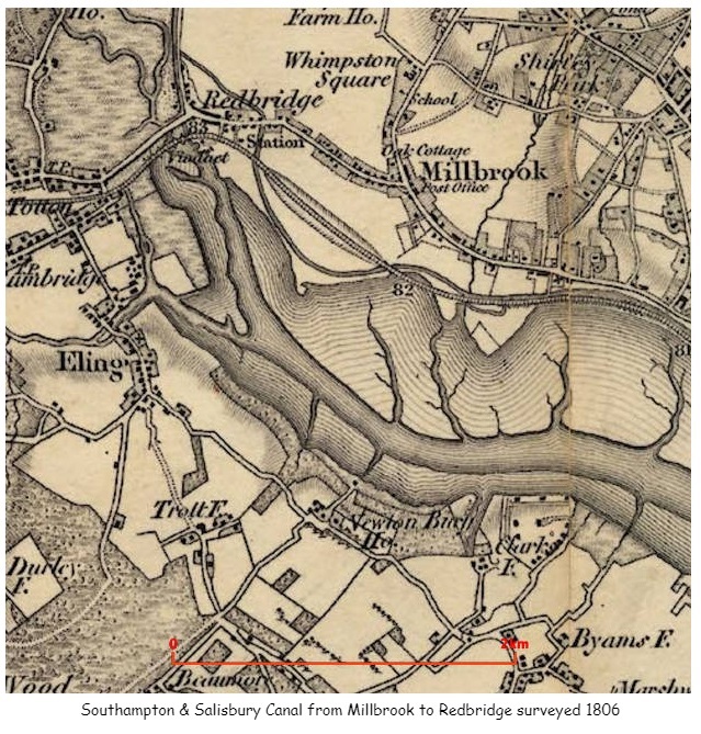
The above map not only shows the canal but also other places around Millbrook including Whimpston Square, which correlates with Wimpston on later maps and a road called Wimpson Square on a 1911 Census record for a family called Street.
The link to the British Library held maps provided invaluable additional information including additional information about names and locations of Turnpike gates to confirm or correct data sourced elsewhere.
A named boundary of the 1841 Census is Cockerwood Land, in District 6 for instance. However, I have not found that road on any current map. There is some reference to Hill Lane on a paper about Taunton's College and a Cockroads Farm shown on some of the old OS Six inch maps.
'A map of Southampton in 1800, by Doswell shows a building next to Hill Lane and known as Cockerwood House. The first OS map of Hampshire shows an unnamed building within a rectangular enclosure. The details are very similar to those shown on the 1826 map of Hampshire. The enclosure map of Hill and Shirley in 1830 shows two main building complexes, both aligned north–south, one adjacent to Hill Lane and the other, to the north-west of it, set slightly back from Hill Lane. This second building interrupts a rectangular enclosure that otherwise surrounds the building on Hill Lane.'
OS 1866 Map Link There is also a short article on Sotonopedia There is also relevant information on OS First Series Map showing Whithedswood Common. Even more interesting is the British Library held map. This map appears to predate the OS First Series and includes Shirley Common, Warren, Shirley, Hill, Whiterswood Common, Cock Road, Shirley House, as well as Millbrook and Redbridge. Whilst the map does have the words Shirley House it is not clear exactly where it is. Possibly somewhere close to Foundry Road. Later maps pin point Shirley House, which in turn suggests that what appears to be Shirley Brick, on the 1806 map above is in fact Shirley Park.
Unsurprisingly, research into one area takes you to another. The Parish of Millbrook on British History Online leads to manors of Millbrook, which again leads to the Manor of Shirley, and latterly Shirley and Hill. This article provides some of the names of the Lords of the Manor in the 13th and 14th Centuries. I will add these names to my One Place Ancestry Tree, The people of Millbrook. Sometimes the entries produce hints and additional information about the person and their family. The most successful of these so far was the Whitehead family who held the the Manor of Shirley and Hill from 1433 until Mary, the daughter of Henry and Mary, married Alexander Thistlethwayte in 1717, and the manor thus passed to the Thistlethwaytes with whom it remained for a further considerable period. Whilst they were holders of the Manor of Shirley and Hill, their main seat appears to have been in Norman Court, West West Tytherley, Hampshire, on the border with Wiltshire. Indeed, Norman Court Park is shown on the OS Map as being the boundary between Hampshire and Wiltshire. Norman Court Park is about 20 miles away from Shirley, so I am unsure if they ever lived in Shirley House. Further investigation quickly reveals that Shirley House was built in the later part of the 18th century for retired West Indian plantation owner, Richard Wilson. It stood at the junction of modern-day Clarendon and Henty Roads. The site is bisected by modern Shirley Park Road, which was named after the estate. Sales particulars of 1792 show it to be a substantial dwelling, with double coach houses, stabling for eight horses, pleasure gardens, a small farm and a large paddock, the total comprising about 48 acres. In 1802 it was occupied by the Reverend Sir Charles Rich and it remained with that family until 1836, when it was sold to property developer William Henry Roe. Roe eventually sold off the estate for development and the house was demolished in the 1880s. More names to add to the Ancestry Tree.
Information on Manors can also be found at the National Archives. The search for Millbrook manor reveals 34 collections held in 4 archives with a date range of 1189 to 1925. Some of these also refer to Nursling Manor, perhaps as the main manor of the two, with some records held at Winchester. Hampshire County Council in the form of the Hampshire Records Office also has a significant number of records, including for instance;-
Plan of Hill and Shirley manor (Whitheds Wood), Millbrook, property of Robert Thistlethwayte, 1778; plan of Hill and Shirley enclosure, 1830; mortgage of tenement on south side of Winchester, John Osman to Elizabeth Merriweather, 1694.
If Nursling Manor and Millbrook Manor are so linked in court records, should I expand my One Place to be Nursling and Millbrook, or add a Nursling One Place Study. The latter is the selection made. Both are registered with the Society of One Place Studies, as Millbrook One Place Study and Nursling One Place Study..
Whilst some of the previous holders of the Manor of Shirley have also been Mayor of the adjacent town, the list of Mayors of Southampton does not include a Whitehead.
The Ancestry tree now includes many generations of Whitehead due to this. Also, I have created an article about Shirley on this site.
Off I go on another side road. From Shirley House or Park, the trail leads me to THE COUNTRY HOUSES OF SOUTHAMPTON By JESSICA VALE. Another paper by the Hampshire Field Club and Archaeological Society. However, perhaps this is not quite so much of a diversion. Some of the early Census Enumerators record the route taken by reference to the large houses of the time, whilst others just record something like 'Shirley Common' for almost the whole of the census. The latter not entirely helpful in establishing locations of dwellings. Even so, sometimes historical papers of old houses reveal the names of the occupants which can be correlated to the census.
The occupancy of Shirley House by the Rich family led me to another long line in Ancestry, then confirmed by other sources.
The Rich Baronetcy, of Shirley House in the County of Southampton, was created in the Baronetage of Great Britain on 28 July 1791 for Reverend Charles Rich. He was the son-in-law of the fifth Baronet of the 1676, and had inherited the estates and assumed the name and arms of Rich. This creation became dormant upon the death of the sixth Baronet in 1983, but heirs are still thought to be living. From Rich baronets.
Another source was the Dictionary of National Biography, Volumes 1-22.
The Rich Baronetcy, of London, was created in the Baronetage of England on 24 January 1676 for Charles Rich, of Mulberton, Norfolk, with remainder to his son-in-law and distant cousin Robert Rich, son of Nathaniel Rich, who inherited the baronetcy the following year. He was a successful politician. His younger son, the fourth Baronet, was a distinguished cavalry officer. The title became extinct on the death of the sixth Baronet in 1799.
Looking into a Nathaniel Rich 1585-1701 takes us into the English Civil War and the formation of the New Model Army. Nathaniel became Colonel of a regiment of horse upon the formation of the New Model Army and was therefore among the first of our professional Army. He fought on Cromwell's side against the King.
I wonder, is the fact that the formation of the current professional army traces back to the Parliamentarians, the reason why it is not a Royal Army, it the way that Royal Navy and Royal Air Force are.
I have just found a possible source of tithe maps of the parishes of Hampshire. This has the potential to significantly aid the correlation of places and families in the 1841 census.
Two interesting metrics I am trying to include into my spreadsheet are voting and adulthood status which requires date thresholds. An interesting summary of the English path to democracy is on the National Archives site.
In my meanderings around the Fifield family and the Standbridge Estate, I found the name Humby, and I have a later relative William Edward Humby 1831-1906; father-in-law of 2nd great-aunt who lived in 1 Rose Hill Cottages, Romsey Road, Old Shirley, Millbrook, Hampshire, England. I have found him in the 1871 Census which I have plotted the Enumerators route and William's home on the map below.
One of the interesting and challenging aspects of plotting locations found in Census returns is the passage of time has eradicated a large number of the buildings and places mentioned. Therefore they cannot be directly plotted onto a current map. Even some current roads were previously known by another name. Reference to old maps helps to resolve some of the locations. It is a slow process, but a worthwhile investment in time and effort. The map below is a collection of places found and plotted. It is still growing, and becomes the basis of Census Enumeration route plots, which in turn will feed data into an ESRI data map.
Another interesting, albeit sometimes unlikely, source of information, is Facebook. There is a group called Freemantle Local History Group. It is fascinating. It is a private group so although I have included links to information sources they may not open for you.
Cedar Lodge House, off Oakley Road, was built in the mid nineteenth century. It was originally called Mussoorie Villa (after a place in northern India). Nearby 2.68 acre Cedar Lodge Park named after the house opened in 1967. Oakley Road was originally called Mousehole lane, renamed Oakley Road in 1909 in honour of the then Mayor, Richard Garrett Oakley.
Another link in the group led me to a collection of Old Maps of Hampshire.
Milne's Hampshire 1791 section 43
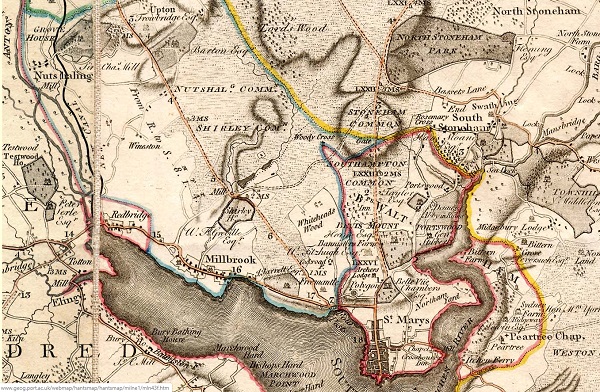
The map shows how rural the whole area was in 1791, with the majority either estates or a huge area of common land. The estates appear to have the names of the owners associated with them. J Jarrett Esq was annotated above Freemantle Park. The size of Nutshalling Common, Shirley Common, and Whiteheads Wood is amazing. So much land in Common usage. Just a few years later the impact of the agricultural and industrial revolutions were clear to see. On the one hand, it is a major land grab by the establishment and the wealthy, but on another it is increasing the productivity of the underutilised and uncared for land, to feed an expanding population. Name changes are also an important consideration. Nutshalling has previously been Nhutscelle, Hnutscilling, Nutshullyng and is now known as Nursling. Whiteheads Wood on this map becomes variously Whitheds Wood, Whithed Wood on later maps. Whithedswood Road becomes Shirley Avenue. Wynsor is shown on this map as Wineston and is now Wimpson. Old roads such as Romsey Road are clearly shown and are still evident whilst Millbrook Road, whilst on a similar alignment but considerable developed. Turnpikes have also come and gone. Shirley is recorded as a manor with a mill in the Domesday Book; the mill standing to the west of the present Romsey Road/Winchester Road junction, at the confluence of the Hollybrook and Tanner's Brook streams. Shirley Mill had three large ponds, to the north of Winchester Road. One of the three mill ponds remains today, accessed by following the Lordswood Greenway. The mill can be seen adjacent to Shirley House and both Hollybrook and Tanner's Brook streams can be seen meandering towards the mill through Nutshalling and Shirley Commons.
Another Map, Taylor's Hampshire 1759 section 43
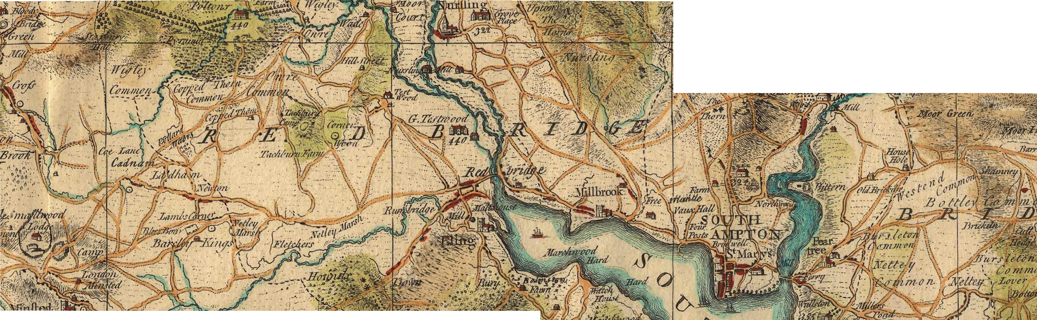
Millbrook is clearly shown on this map, with Freemantle, Vaux Hall, and Four Posts between it and Southampton. Mouse over the image to zoom in to Millbrook. Grove Place and Nursling is at the top the map. Shirley, despite being mentioned in the Domesday Book is not identified on this map.
Shirley was a settlement in Domesday Book, in the hundred of Mansbridge and the county of Hampshire.
It had a recorded population of 12 households in 1086.
Land of Ralph of Mortimer
Households
Households: 4 villagers. 3 smallholders. 5 slaves.
Land and resources
Ploughland: 8 ploughlands. 2 men's plough teams.
Other resources: Meadow 12 acres. Woodland 6 swine render. 1 mill, value 2 shillings and 5 pence. 1 fishery. 1 church.
Valuation
Annual value to lord: 5 pounds in 1086; 5 pounds when acquired by the 1086 owner; 5 pounds in 1066.
Owners
Tenant-in-chief in 1086: Ralph of Mortimer.
Lord in 1086: Ralph of Mortimer.
Overlord in 1066: King Edward.
Lord in 1066: Cypping (of Worthy).
The Domesday Book records a church being present at Shirley in 1085, but on 1 May 1574 the parish of Shirley was amalgamated with that of Millbrook as the small Shirley congregation could not afford the upkeep of the Shirley church building. The Shirley church was demolished in 1609, with stones from the old building used to enlarge St Nicholas' Church building in Millbrook.
By 1836, the population of the combined parish had reached 2,375 inhabitants, and the old Millbrook parish church was too small. Land was donated for a new church building in Shirley by Nathaniel Newman Jefferys, and Church Building Society combined with private funding to pay for the structure itself. The new church, dedicated to St. James, was designed by local architect William Hinves and consecrated on 20 August 1836 by the Bishop of Winchester with a large crowd present despite "unfavourable weather", according to the Hampshire Advertiser newspaper.
Some extracts from a paper presented to Hants Field Club entitled FIELD SYSTEMS AND ENCLOSURES IN HAMPSHIRE
Hampshire was among the counties reported upon by Wolsey's Commission in 1517.
... 37 Hundreds and eight liberties at which the County (including the Isle of Wight) was divided. The Hundreds for which enclosures are recorded are :
Basingstoke, Crondall, Kingsclere, Mansbridge, Odiham, Redbridge, Shutterley (i.e. • Chuteley) and Somborne, and the places. mentioned are : Al( d)ington recte Aldington, Bewraper (Beaurepaire), Bramsyll " Breche and Sockborowe " (field names only ?),. Dogmersfelde (Dogmersfield), Erleston (Earlston), Ewurst. (Ewehurst), Farley . (Fafleigh Chamberlayne),- Ichill, " Loke Dewer," " Newtosberye," Wynsor (in Millbrook Parish ?), and the total area is some 562 acres.
Hampshire is not included among the 14 counties covered by the Depopulation Act of 1536, though curiously enough the Isle of Wight is.
The County Agricultural Survey was written by the. Drivers, who describe themselves as " of Kent Road, Surrey." They are sorry to observe in the County such immense tracts of open heath and uncultivated land, which tend to remind the travellers of voyages among the barbarians ; they point out, however, that in this respect Hampshire is no worse than Wiltshire and Dorset, perhaps a trifle better. This is no excuse for it. Near Southampton is a great deal of open land which if enclosed and cultivated will give good crops of corn. There are large downs towards Fareham and Warnford,85 and much open land with some good down near Petersfield. As to the forests and wastes, the Drivers are astonished that the Crown Lands in particular should have remained so long in a state of neglect. If properly managed they would pay much of the interest on the National Debt. A general Act should be passed at once, preferably entrusting enclosure to the Commissioners of Crown Lands:
As to other open land, it might well not be worth enclosure for tillage, and still be worth taking in for planting. No " gentleman can sit down easy, and say he has discharged his duty to his family when he is conscious he has neglected to pursue those measures, which, in a few years, would increase his property so amazingly." . Commonable land of every kind can be regarded as little better than waste, since everyone exhausts it, and no one pays the least • attention to. its support and improvement. "All this would be easily remedied by a general inclosure bill, which would reduce the expense. of inclosures, and would be a spur to that improvement." Wool production would certainly not decrease on enclosure, every farmer in his own interest keeps as many sheep as he is able, and he can feed twice as many on land in severalty as on the corresponding area in common.
Note the reference to Depopulation and read more about it here. By 1530 the population of England and Wales had risen to around 3 million. At the end of the 17th century it was estimated the population of England and Wales was about 5 1/2 million. The population of Scotland was about 1 million. The population of London was about 600,000. London went on to become the biggest city in the world for a while. In the 19th century Britain became the world's first industrial society. It also became the first urban society. By 1851 more than half the population lived in towns. As our population approaches 70m it is interesting to think of depopulation efforts at 3 million! The maps of Millbrook clearly show the urbanisation of the countryside.
Following the Tithe Commutation Act 1836 Tithe Maps were produced which recorded both the Landowner and Occupier for most lands. From the Tithe Apportionments records it is apparent that on 4th March 1843 Lady Hewitt
was both the Landowner and Occupier of Plot 875, Freemantle Estate, described as House Offices and Pleasure Grounds, with an area in statute measure 6,0,2, about 2.4 Hectares.
Nathaniel Newman Jefferys was both Landowner and Occupier of Plot 825 described as House Offices and Garden, an area of 2,2,24 imperial, on 4th March 1843. However, one plot does not show the full picture.
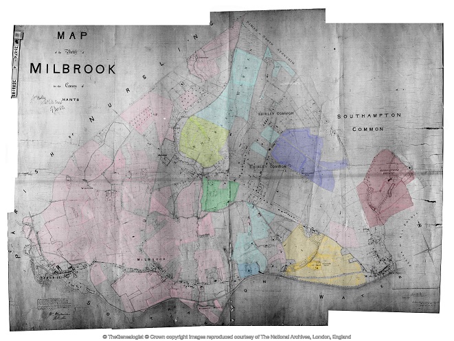
Using the Tithe Apportionment map of the Parish of Millbrook, Hampshire, as a base, I have colour washed some of the plot landowners. The Freemantle and Banister Estates, pale orange and brown respectively can be clearly seen. The landowners in 1843 where Lady Hewitt and Reverend William Fitzhugh. Shirley Park, owned by William Henry Roe, is in green. Blightmont Lodge, occupied by Lady Lisle, just north of Millbrook Road, and part of the larger Berrywood estate owned by Nathaniel Newman Jefferys is shown in a slightly darker blue than the light blue of the rest of the estate. It appears that Nathaniel Newman Jefferys has bought a large swath of the newly released Shirley Common land in the area of Shirley Warren. Clement Hoare & William Dunn seem to have also taken advantage of the inclosue of Shirley and Nutshalling Commons, as joint owners of plots coloured lime green. Roads such as Warren Avenue, Warren Crescent and Tremona Road have already been laid out for the impending urbanisation. However, the biggest landholding in the Parish, by a long way, is Sir John Barker Mill and various associates who together are landowners of the pink coloured plots, mainly farmland in 1843, but destined to be developed and absorbed as suburbs of Southampton.
Greenwood's Hampshire 1826 section 53
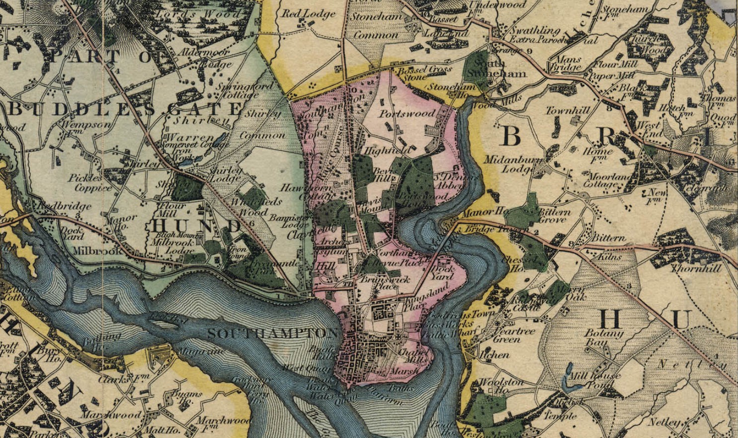
Moving into the current, the Church of England has a database of interesting statistics about all the Parishes in the country. Below is the Map which covers the original Millbrook Parish and shows the current Parishes of;
Millbrook: Holy Trinity
Freemantle: Christ Church (1851)
Shirley: St James (1836)
Maybush.
Click on the parish to bring up the statistics.
The Parish of Millbrook Tithe Map 1843 including Shirley, Freemantle and Four Posts, layered onto Google Earth Pro and Geolocated. Same base map as the coloured ownership map. Over 20 separate tiles or files to fit spherical base globe of Google Earth. All adjusted to best fit the projection, and align roads and as many details as possible. Below is just an image of the result. Google Earth Pro is desktop based so does not lend itself to sharing. However, using transparency of the layers I can locate buildings on the tithe map and see what is there now. I can also use the Lat and Lon and show on Google Maps to georeferenced individual buildings or plots.
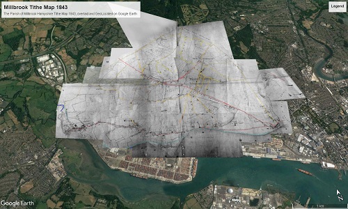
The interactive version is created using a Project in Google Earth and can be seen here, The Parish of Millbrook Tithe Apportionment. Using the Tithe Map plotted on Google Earth Pro above and other maps, I have placed some of the Property names onto a Google Earth Project with an up to date backdrop. History mapped to now.
A screenshot as at March 2020. Work ongoing.
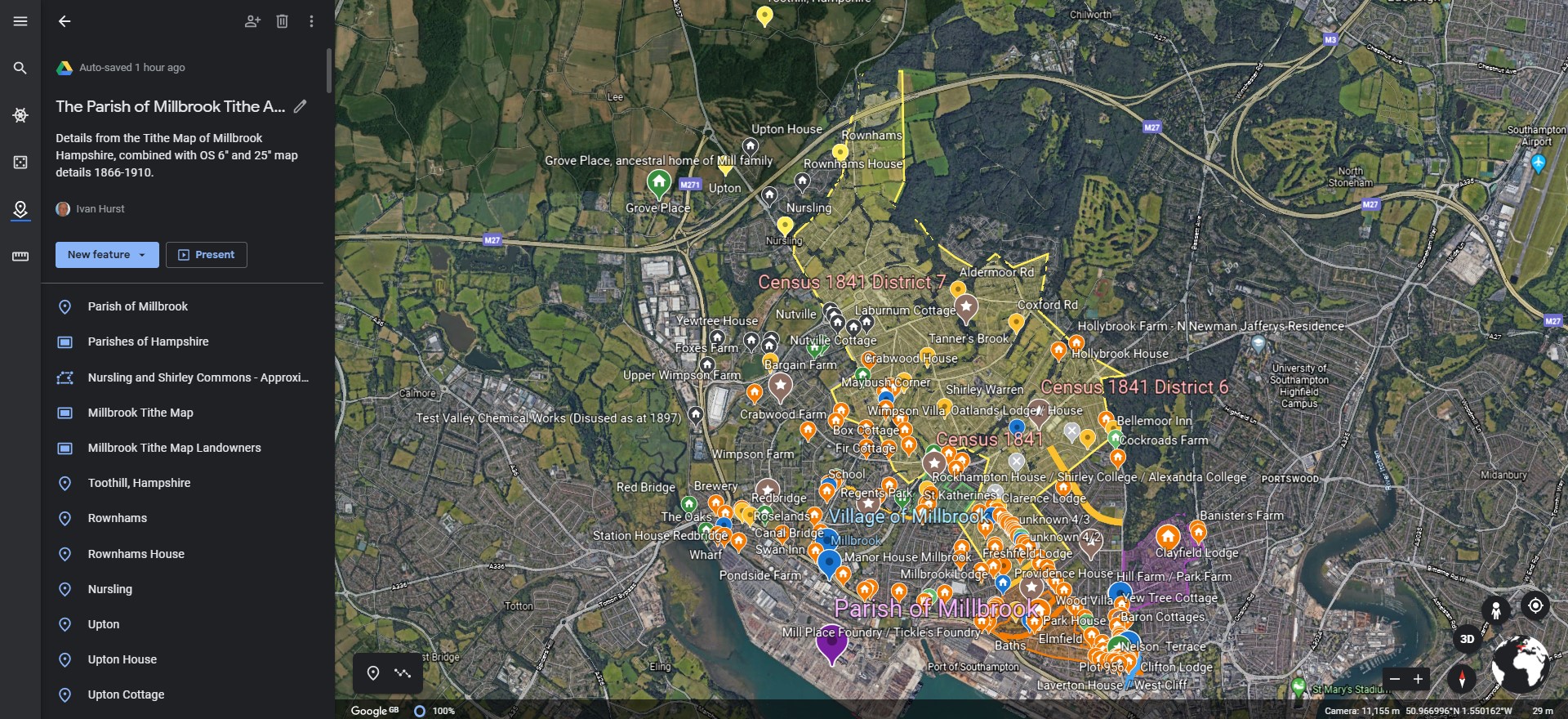
Freemantle
Freemantle Estate
Narrative
Broadly in chronological order but with some exceptions.
Prehistory
Prehistory
Palaeolithic, Neolithic, and Bronze Ages.
Pre-Roman before 43AD
Pre-Roman before 43AD
Roman - 43 to 410AD
Roman Occupation - 43 to 410AD
Early Medieval - 411 to 899AD
Early Medieval - 411 to 899AD
High Medieval - 900 to 1349AD
High Medieval - 900 to 1349AD
Millbrook Manor
Millbrook Manor
Anglo-Saxon Charter of 956
The Anglo-Saxon Charter of 956, specifically the grant of 7 hides (cassati) at Millbrook, is a significant document that provides insight into the ancient boundaries of the Manor of Millbrook. This charter, which is part of the collection of Anglo-Saxon charters, includes a haga in Southampton, Hants, and is printed in Latin with English bounds. It is a valuable source for understanding the historical context and legal framework of the time.
S 636
The Sawyer number for the charter referring to Millbrook Manor from A.D. 956 is S 636. This charter was granted by King Eadwig to Wulfric, his princeps, and includes details about the grant of 7 hides at Millbrook..
The listing in The Electronic Sawyer, the online catalogue of Anglo-Saxon Charters
S636 A.D. 956 (ii). King Eadwig to Wulfric, his princeps; grant of 7 hides (cassati) at Millbrook, with a haga in Southampton, Hants. Latin with English bounds, Winchester, Old Minster
- Endorsements: (1) in a contemporary hand: + ˇis is ˇara . VII . hida boc æt Melebroce ˇe Eadwig cing gebocode Wulfrice his ˇegne on ece yrfe . (2) in a hand of late s. xv: VII hyda in Mylbrooke . saxon . Px Anno heroicæ incarnationis DCCCCLVI . Indictione . XIIII . Eadwig numine cælesti gentis Geuuisorum orientaliumque nec non occidentalium simul etiam aquilonalium Saxonum archons cuidam meorum principum quem nonnulli vocitant noto vocamine . Wvlfric . VII . cassatos perpetualiter trado . illic ubi vulgariter dicitur . æt Melebroce . quandiu hic corpus animatum habere videbitur nostri doni privilegium sibi vendicet et postero denique suo quemcumque elegerit pereniter impertiat cum campis . pascuis . pratis . silvis . Hæc tellus a cuncto sit immunis servitu nisi pontis . et arcis . ac expeditionis juvamine . Si quis autem infringere temptaverit quod absit . sciat se rationem redditurum coram Deo et angelis ejus . nisi prius hic digna satisfactione emendare satagerit . Istis terminis ambitur prædicta tellus . ˇis synt ˇa land gemæro to melebroce . ærest of hreodbrycge 7lang st'r'æte on fearninga broce 7lang mearce on melebroces ford east 7lang mearce on ˇunres lea norˇeweardne ˇonon 7lang weges on cinges dic ˇonon 7lang mearce on holan weg of ˇam wege on ˇa ea oˇ midne stream 7lang streames on hreodbrycge . 7 se haga an ham tune ˇe ˇærto gebyret . + Ego Eadwig rex Anglorum indeclinabiliter concessi . + Ego Eadgar ejusdem regis frater consensi . + Ego Oda archiepiscopus cum signo sanctæ crucis + roboravi . + Ego Ælfsinus presul sigillum agiæ crucis + impressi . + Ego Oscytel episcopus consignavi . + Ego Osulf episcopus adquievi . + Ego Wulfsige episcopus subscripsi . + Ego Byrhthelm episcopus conclusi . + Æˇelstan dux . + Eadmund dux . + Byrhtferˇ dux . + Ælfhere dux . + Ælfsige minister . + Wulfric minister . + Æˇelgeard minister . + Ælfheah minister . + Ælfgar minister . + Byrhtferˇ minister . + Ælfred minister .
- Translation by Google ...
- ˇis is ˇara . VII . hida boc æt Melebroce ˇe Eadwig cing gebocode Wulfrice his ˇegne on ece yrfe . (2) in a hand of late s. xv: VII hyda in Mylbrooke . Saxon . Px Year of heroic incarnation DCCCCLVI . Indictione . XIVII . Eadwig the celestial god of the Geuuises, the eastern and western Saxons, together with the northern Saxons, archons of some of my princes, whom some call by a well-known name . Wvlfric . VII . I hereby permanently cancel . where it is commonly said . æt Melebroce . as long as he appears to have an animate body, he will claim the privilege of our gift and finally grant it to his posterity whomever he chooses, with fields . pastures . meadows . forests . This land shall be immune from all service except for the bridge . and the castle . and the aid of the expedition. But if anyone attempts to infringe, which is far from it. Let him know that he will give an account before God and his angels. Unless he first makes a worthy amend here with satisfaction. The aforesaid land is encompassed by these terms. This is the land of the gemæro to melebroce. The east of Hreodbrycge is on the east of Fearninga Broce. The east of Melebroces is on the east of Unres Lea Norˇeweardne. Ononon is on the west of Holan Weg of Am Wege on the west of Midne Stream. He shall do this and do this. + I, Eadwig, king of the English, have granted it without hesitation. + I, Eadgar, brother of the same king, have consented. + I, Oda, archbishop, have strengthened it with the sign of the holy cross. + I, Ælfsinus, presbyter, have impressed the seal of the golden cross. + I, Oscytel, bishop, have signed. + I, Osulf, bishop, have agreed. + I, Wulfsige, bishop, have subscribed. + I, Byrhthelm, bishop, have concluded. + Æˇelstan, duke. + Eadmund, duke. + Byrhtferˇ, duke. + Ælfhere, duke. + Ælfsige, minister. + Wulfric, minister. + Æˇelgeard, minister. + Ælfheah, minister. + Ælfgar, minister. + Byrhtferˇ, minister. + Ælfred, minister
There are some places named:- The east of Hreodbrycge is on the east of Fearninga Broce. The east of Melebroces is on the east of Unres Lea Norˇeweardne. Ononon is on the west of Holan Weg of Am Wege on the west of Midne Stream.
- Hreodbrycge is probably Redbridge.
- Fearninga Broce
- Melebroces
- Unres Lea Norˇeweardne
- Ononon
- Holan Weg
- Am Wege is probably Hamtun, later Southampton
- Midne Stream.
More information in King's College London ASChart (but it has not got to S636 yet)
A hide is equal to approximately 120 acres. Historically, this measurement was used to denote the amount of land sufficient to support one household, with most counties recognizing it as 120 acres. Hence 840 acres for Millbrook Manor, (about 340 Hectares) and that size is before the addition of Shirley.
According to an Anglo-Saxon Charter of 956 Aldermoor, Lordswood, Lordshill and Coxford are all within the ancient boundary of the Manor of Millbrook.
Information on Manors can also be found at the National Archives. The search for Millbrook Manor reveals 34 collections held in 4 archives with a date range of 1189 to 1925. Some of these also refer to Nursling Manor, perhaps as the main manor of the two, with some records held at Winchester. Hampshire County Council in the form of the Hampshire Records Office . Which also has a significant number of records, including for instance;-
Plan of Hill and Shirley manor (Whitheds Wood), Millbrook, property of Robert Thistlethwayte, 1778; plan of Hill and Shirley enclosure, 1830; mortgage of tenement on south side of Winchester, John Osman to Elizabeth Merriweather, 1694.
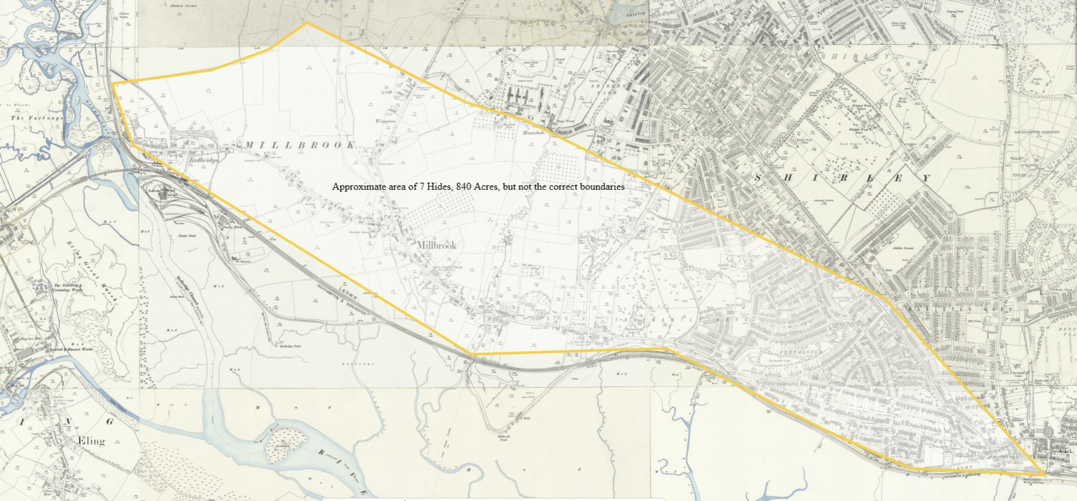
An old OS 25" map, including Millbrook with an area of approximately 7 Hides, 840 Acres, superimposed on the map. Just to give an idea of the size of an award of 7 Hides, with no intention to imply or state the location of the boundaries of the Manor of Millbrook after 956.
Currently, my research has not found any evidence of a Manor House or Church of that period, or location of. Both a Manor House and St Nicholas's Church can be seen on the much later map. See pins on map below.
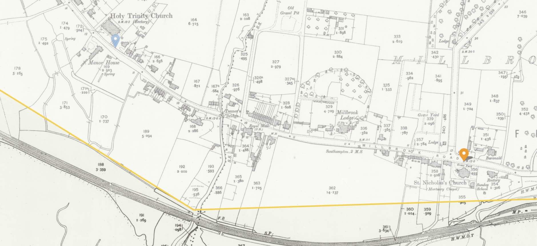
Both the Manor House and the church indicated above are on the route of the new(ish) Millbrook Road dual carriageway, so I suspect the Manor House was not that old, and St Nicholas's Church had already been demolished following the building of its replacement, Holy Trinity Church, near the Manor House. The later church is still there.
Although, perhaps it was older than I thought. In the decades after the war, the Establishment was not as concerned with preservation as it is today.
Manor house shown and named on 19th and early 20th century Ordnance Survey maps and probably also shown on late 18th century mapping. The house was part of the village of Millbrook (MSH3132), but some way to the west of the now-demolished medieval church. The building had been demolished by 1947 and the grounds obliterated. The site is now part of an industrial estate.
Some medieval and post-medieval artefacts were found during archaeological investigations at Unit 1, Third Avenue in June 2017 (SOU 1757). The artefacts were found in a buried garden soil, probably associated with the grounds of the manor house. Some ponds and drainage features were also found, one of which may have been within the grounds, and another on the south boundary of the grounds.
HER 5/2/2020: See MSH5866 for the results of this fieldwork. The north part of the site lay within the former grounds of Millbrook Manor House, although the south part had probably been fields. The manor house itself lay to the north. The evaluation trenches recorded some ponds and drainage features shown on OS mapping to 1947. One of these may have been in the manor house grounds, and another was on the south boundary of the grounds. In the north part of the site, a buried topsoil or garden soil overlay natural deposits; this was probably associated with the former manor, being the ground surface prior to WWII. The buried soil contained a few late medieval and 17th century finds, and a tile fragment of possible Roman date, although most of the finds were late post-medieval to modern. Above the buried soil, and filling the ponds and drainage features, was a considerable depth of modern made ground; the 1947 map shows the area being used as a rubbish tip. By 1952 a new building had been constructed on the site.
Unfortunately the agreed evaluation trench locations did not include an evaluation trench in the north part of the site closest to the location of the manor house. The northernmost evaluation trench, Trench 3, was some way from the manor house. During the watching brief on construction, very few of the groundworks in the northern area were observed.
St Nicholas's Church in Millbrook was built in the 13th century, with its first record dating back to 1282. It was largely rebuilt in 1824 but became increasingly dilapidated, leading to its demolition in 1939. Holy Trinity was built as a replacement for the ancient Parish Church of St Nicholas, Millbrook. Even after the consecration of Holy Trinity in 1874, services continued intermittently at St Nicholas until 1920. The old church sudden collapsed five days after the last service. The remains of St Nicholas's Church were completely demolished after World War II.
But I have jumped from 956 to 1945, nearly 1000 years. Time to get back in sequence.
Domesday Book
Domesday Book - The Great Survey - 1086
Domesday Book ( the Middle English spelling of "Doomsday Book") is a manuscript record of the Great Survey of much of England and parts of Wales completed in 1086 at the behest of William the Conqueror. The manuscript was originally known by the Latin name Liber de Wintonia, meaning "Book of Winchester", where it was originally kept in the royal treasury. The Anglo-Saxon Chronicle states that in 1085 the king sent his agents to survey every shire in England, to list his holdings and dues owed to him.
Written in Medieval Latin, it was highly abbreviated and included some vernacular native terms without Latin equivalents. The survey's main purpose was to record the annual value of every piece of landed property to its lord, and the resources in land, labour force, and livestock from which the value derived.
The name "Domesday Book" came into use in the 12th century. Richard FitzNeal wrote in the Dialogus de Scaccario (c. 1179) that the book was so called because its decisions were unalterable, like those of the Last Judgment, and its sentence could not be quashed.
The manuscript is now held at the National Archives in Kew, London. Domesday was first printed in full in 1783, and in 2011 the Open Domesday Web site made the manuscript available on the Internet.
Millbrook is recorded as being in the Hundred of Mansbridge.
Hundred of Mansbridge
There were 16 places in the hundred of Mansbridge in Domesday Book.
A total of 459 households in the Hundred, with 40% being in Southampton. The three entries of Millbrook, Shirley, and Redbridge, total 45 households, 10%.
This clearly indicates that Millbrook, Shirley, and Redbridge, were all in the Hundred of Mansbridge. However, on the Norden's Map of Hampshire, 1607, they were in the Hundred of Redbridge.
See an extract of the map in the 1600 - 1800 Section.
Using the above list of place names, I have plotted them on old OS maps and a recent Open Street Map. I have not tried to infer a boundary of Mansbridge from that information, I will leave that to you. There is one place missing, Hinton, which if it is Hinton Ampton, is too much of an outlier to be useful, and if it is Hinton, I have not yet found it. For these screenshots, I have not found Allington either, but with the ESRI map below, I have.
I used the 1 inch OS map to plot the places.
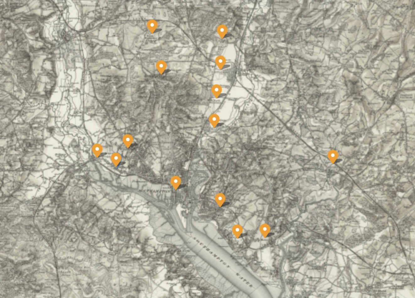 Domesday Book Places in the Hundred of Mansbridge OS 1 inch Map - 1885 - 1903 - Hills
As with other OS Maps herein, it is not zoomable here, but click on the map to take you to the source, where you can. Unfortunately, the markers will not persist in the source view.
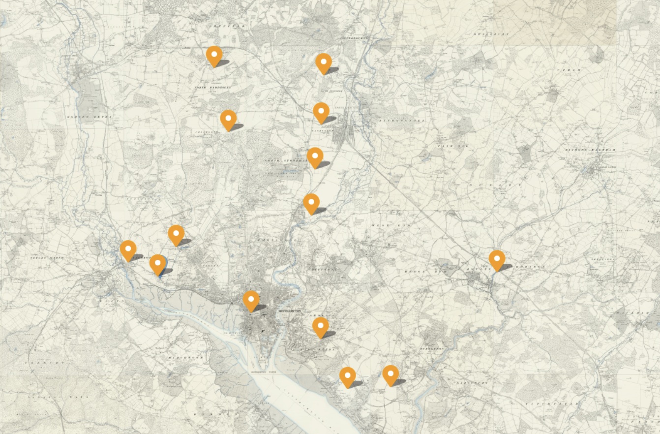 Domesday Book Places in the Hundred of Mansbridge OS 6 inch map 1888 - 1915
Same markers as before but the underlining map is now OS 6".
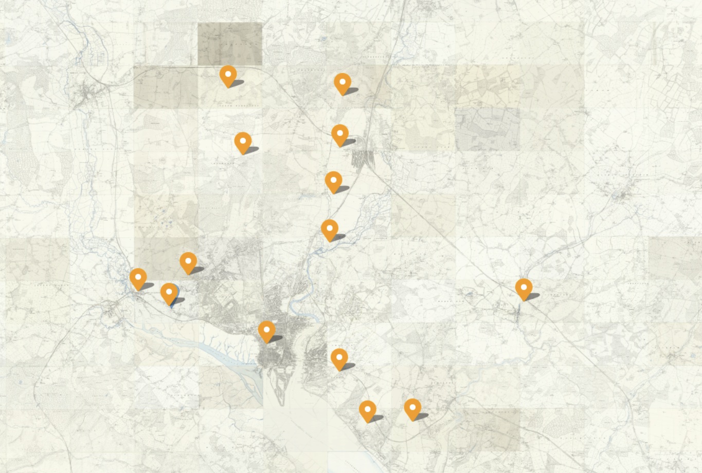 Domesday Book Places in the Hundred of Mansbridge OS 25 inch map 1892 - 1914
Now, my normal go to map, the OS 25". It does not add much. The 25" is much more suited to being zoomed in very close to the detail, sometimes to an individual property. That competes the set of old Ordnance Survey Maps from the National Library of Scotland.
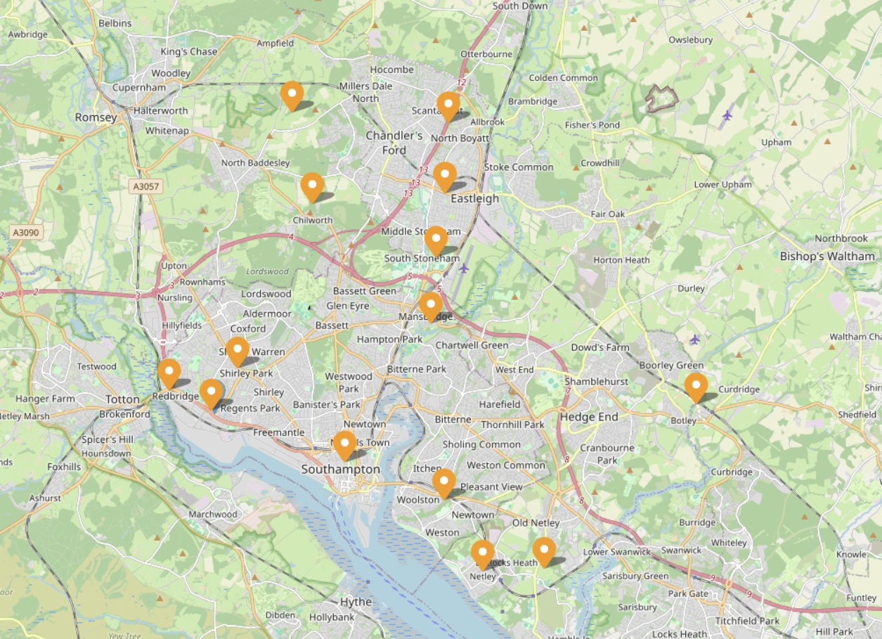
A quick change of the transparency level and the underling base map is revealed. There are many to select from, and this is the Open Street Map. That is on the source map of course, these are just static screen shots.
Much easier to see comparative locations on this view. Note, North Baddesley appears to have moved somewhat. The plotted position is now referred to as Old North Baddesley.
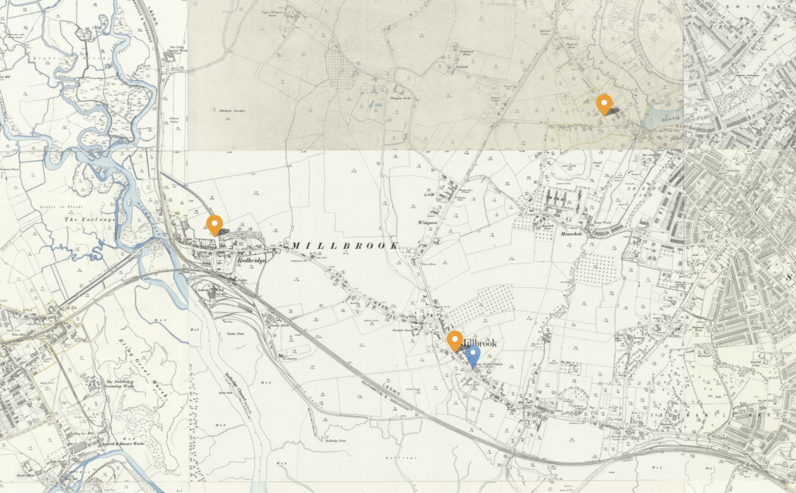 Domesday Book Places in the Hundred of Mansbridge OS 25 inch three places, Millbrook, Redbridge, and Shirley
A closer slice of the above OS 25" map for the three places of interest, Millbrook, Redbridge, and Shirley.
Hoping to add interactive ESRI map of the above, here.
xxxxxxxxxxxxxxxxxxxxxxxxxxxxxxxxxxxxxxxxxxxxxxxxxxxxxxxxxxxxxxxxxxxxxxxxxxxxxxxxxxxxxxxxxxxxxxxxxxxxxxxxxxxxxxxxxxxxxxx
An ESRI map of 15 of the 16 places listed in the Domesday book, The Great Survey of England, as being in the Hundred of Mansbridge.
I am hoping that it appears on your view, as it does mine.
Whereas the other maps were screenshots of a map, this one is zoomable, interactive. With the icon in the top left you can change which basemap it displays. I believe that when the page is refreshed, it reverts to the initial basemap, On the right hand side there are some more icons, including one to open it in ESRI's Map Viewer, it's native environment. The markers have popups, which show the name of the place, together with the Domesday name, and a little information from the Domesday entry.
The markers for the Hundred of Mansbridge are an inverted raindrop, in black with a round spot in the top. The map is initially focused on Mansbridge.
The markers with the green dots are the ones that are the subject here, Millbrook, Redbridge, and Shirley. The marker with the red dot is Southampton, the major population centre in the Hundred of Mansbridge, at 40% of the whole.
The smallest population is 5 households in Redbridge.
The markers for the Hundred of Buddlesgate are a circle with a straight line from the bottom leading to a cross, x. It also has a round spot in the top. There are only four places in the Domesday Book in the Hundred of Buddlesgate, two of which can be seen here. Nursling is our place of interest in the Hundred of Buddlesgate, and it is coloured blue.
The markers for the Hundred of Redbridge are a circle with a straight line from the bottom. The ancient Parish of Eling is our place of interest in Hundred of Redbridge, and those markers are coloured yellow.
Hundreds of Mansbridge, Buddlesgate, and Redbridge
The map currently has the places of three Hundreds, Mansbridge, Buddlesgate, and Redbridge, extracted form the Domesday Book of the Great Survey of England, and plotted therein. The focus is on Mansbridge, with the other two included for comparison.
There were 16 places in the hundred of Mansbridge in Domesday Book. I have not been able to locate Hinton within the Hundred of Mansbridge. 15 are plotted on the above map.
There were 4 places in the hundred of Buddlesgate in Domesday Book. All 4 are plotted on the above map.
There were 24 places in the hundred of Redbridge in Domesday Book. Lestred, Achelie, Buckholt, Northam, and Nutlei have been officially declared as lost within the Hundred of Redbridge. 19 are plotted on the above map.
The combined population of Millbrook, Redbridge, and Shirley in 1086 was 45 households. For comparison, Nursling was 30, and the ancient Parish of Eling constituents were 109, of which Eling alone was 69.
xxxxxxxxxxxxxxxxxxxxxxxxxxxxxxxxxxxxxxxxxxxxxxxxxxxxxxxxxxxxxxxxxxxxxxxxxxxxxxxxxxxxxxxxxxxxxxxxxxxxxxxxxxxxxxxxxxxxxxx
Millbrook
Link to the Open Domesday Entry for Millbrook,
Millbrook was a settlement in Domesday Book, in the hundred of Mansbridge and the county of Hampshire.
It had a recorded population of 28 households in 1086, putting it in the largest 40% of settlements recorded in Domesday.
| Land of |
Winchester (St Peter & St Swithin), bishop of |
|
| Households | ||
| 28 villagers. | ||
| Land and resources | ||
| Ploughland: | 5 ploughlands. 5 men's plough teams. | |
| Other resources:. | Meadow 14 acres. Woodland 5 swine render. | |
| Valuation | ||
| Annual value to lord: | 5 pounds in 1086; 5 pounds when acquired by the 1086 owner; 5 pounds in 1066 | |
| Owners | ||
| Tenant-in-chief in 1086: | Winchester (St Peter & St Swithin), bishop of. | |
| Lord in 1086: | villagers. | |
| Overlord in 1066:. | Winchester (St Peter & St Swithin), bishop of. | |
| Lord in 1066: | villagers. | |
| Other information | ||
| Phillimore reference: | Hampshire 3,17 |
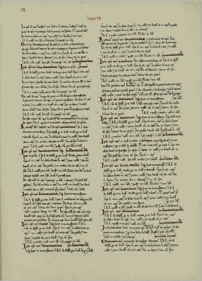
A copy of the page of the Domesday Book, 1086, with the entry for Millbrook, enlarged below.
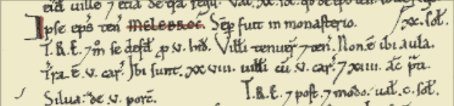
Millbrook was called Melebroc in the Domesday book, as can be seen above.
Shirley
Link to the Open Domesday entry for Shirley
Shirley was a settlement in Domesday Book, in the hundred of Mansbridge and the county of Hampshire.
It had a recorded population of 12 households in 1086.
| Land of |
Ralph of Mortimer |
|
| Households | ||
| 4 villagers. 3 smallholders. 5 slaves.. | ||
| Land and resources | ||
| Ploughland: | 8 ploughlands. 2 men's plough teams. | |
| Other resources:. | Meadow 12 acres. Woodland 6 swine render. 1 mill, value 2 shillings and 5 pence. 1 fishery. 1 church | |
| Valuation | ||
| Annual value to lord: | 5 pounds in 1086; 5 pounds when acquired by the 1086 owner; 5 pounds in 1066. | |
| Owners | ||
| Tenant-in-chief in 1086: | Ralph of Mortimer. | |
| Lord in 1086: | Ralph of Mortimer. | |
| Overlord in 1066:. | King Edward. | |
| Lord in 1066: | Cypping (of Worthy). | |
| Other information | ||
| Phillimore reference: | Hampshire 29,5 |
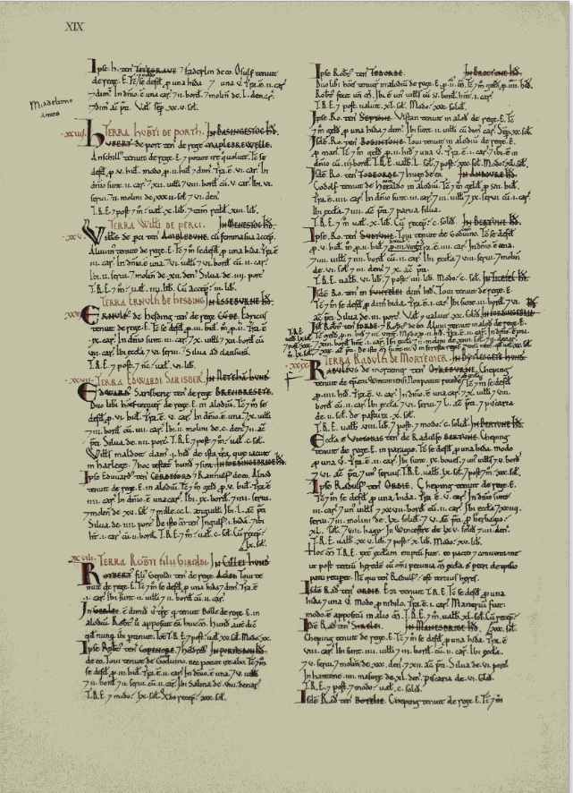
A copy of the page of the Domesday Book, 1086, with the entry for Shirley, enlarged below.
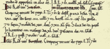
Redbridge
Link to the Open Domesday entry for Redbridge
Redbridge was a settlement in Domesday Book, in the hundred of Mansbridge and the county of Hampshire.
It had a recorded population of 5 households in 1086, putting it in the smallest 20% of settlements recorded in Domesday.
| Land of |
Bishop Odo of Bayeux |
|
| Households | ||
| 4 villagers. 1 smallholder. | ||
| Land and resources | ||
| Ploughland: | 1 men's plough teams. | |
| Other resources:. | Meadow 1 acres. 2 mills, value 2 pounds 10 shillings. | |
| Valuation | ||
| Annual value to lord: | 3 pounds in 1086; 10 shillings when acquired by the 1086 owner; 10 shillings in 1066. | |
| Owners | ||
| Tenant-in-chief in 1086: | Bishop Odo of Bayeux. | |
| Lord in 1086: | Hugh of Port. | |
| Overlord in 1066:. | King Edward. | |
| Lord in 1066: | Tovi. | |
| Other information | ||
| Phillimore reference: | Hampshire 23,66 |
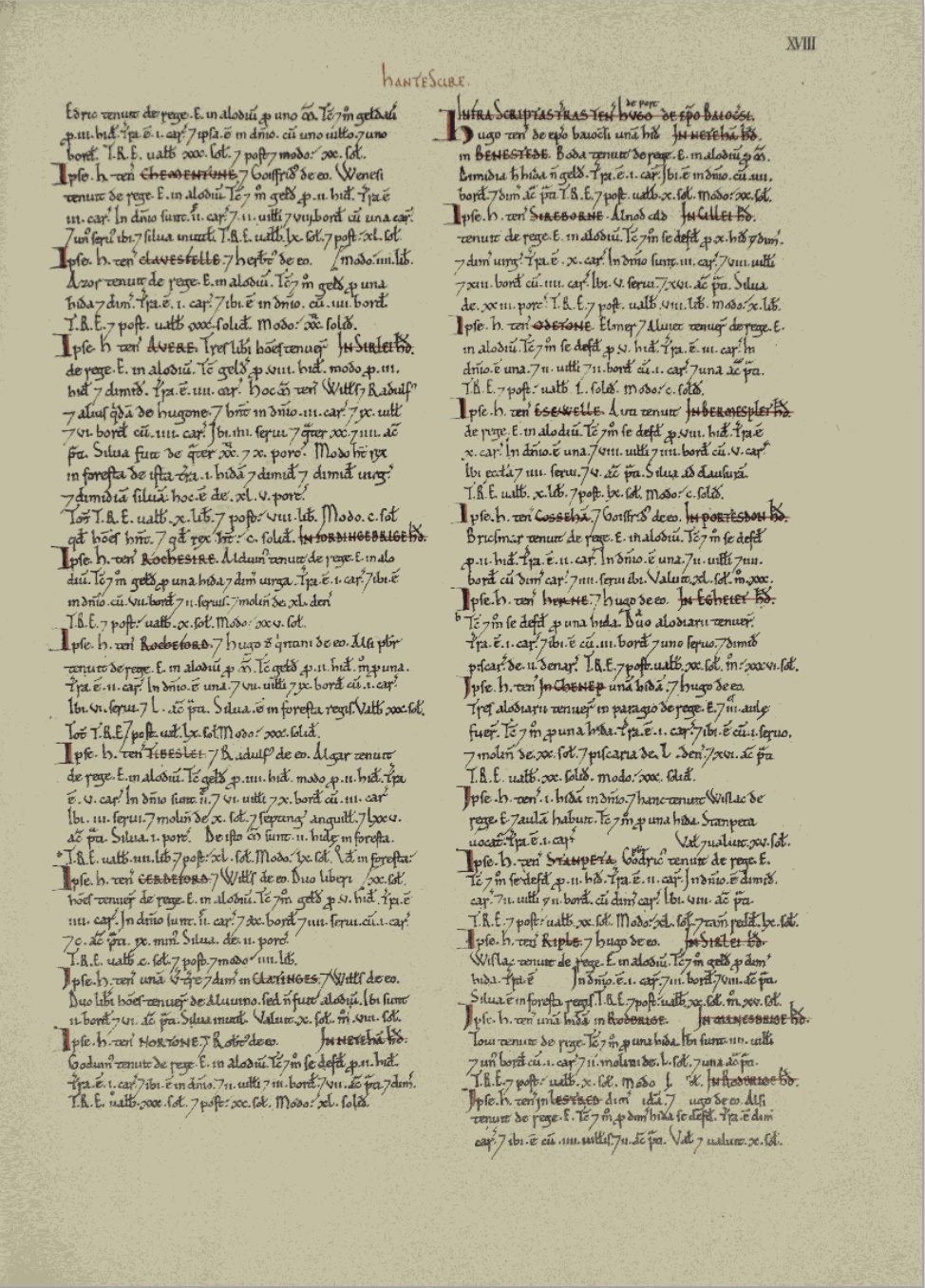
A copy of the page of the Domesday Book, 1086, with the entry for Redbridge, enlarged below.
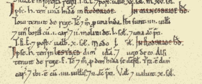
The settlements of Wimpson and Hill, mentioned on some later maps, are not found in the Domesday Book.
Late Medieval - 1350 to 1539
Late Medieval - 1350 to 1539
Millbrook Church
The first record of the church of Millbrook is in 1282, when it was noted as being in the Deanery of Southampton. It belonged to the Bishop of Winchester. It's date of construction is not known.
The church became very delapidated and in 1872 the new church - Holy Trinity - was built (on a different site - SU3852 1308 IP). Thereafter the church was occasionally used until 1921 when it closed. By 1939 it had been completely demolished, and the whole churchyard cleared. A caravan park was established on the site and the tower foundations were converted into a flower bed.
Prior to being pulled down the body of the church consisted of a plain 15th century tower of three stages, while the rest was a rebuild dating to 1824.
The church is shown on the pre-WWII Hampshire map.
In 1797 an Act was secured to rebuild part of the old church.
The area of the church is now under Millbrook Road West.
Although the above ground church has been destroyed, the extent of survival of below-ground remains is unknown.
Includes a photograph of the church. See web site.
Concerning a wall monument installed in St Nicholas Church, Millbrook in the 1830's. This was a carving by the well known sculptor, Edward Hodges Baily (sculptor of Nelson on Nelson's Column). It was commissioned by Nathaniel Ogle in memory of his mother, Anna Maria Ogle (of the Ogle family of Southampton). The sculpture was described when it was exhibited at the RA in 1830, prior to its placement in the church. No image of it exists. Probably lost when the church was demolished.
Early 20th century photograph, with the church in the background. Found on a Facebook site
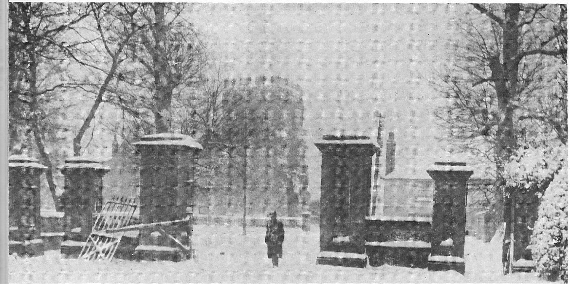
This set of gates used to be the entrance to the Regent's Park Estate. They were situated at the Millbrook Road end of Regents Park Road. The church in the background was the orginal Millbrook Church. Some of the stones for this church were brought down from the orginal village of Shirley which was situated around the area of Winchester Road/Romsey Road cross roads. Before Percy Road was built excavations took place and a grave site containing over 200 human remains and the site of an old church. That was were the Millbrook Church stones came from. I wonder if the stones were used when the present Millbrook Church was built?
Words from Rod Andrews on Facebook
Plus a comment from Eric Payne
A great picture. This must have been taken pre 1939 as I believe the church was demolished in that year. After Sat morning flicks at the Atherly, us kids very often headed for the old graveyard to play out our games of cowboys and Indians. I had a bit of a shock recently when my young grandson aged 7 asked "What's a cowboy?"
Shirley Church
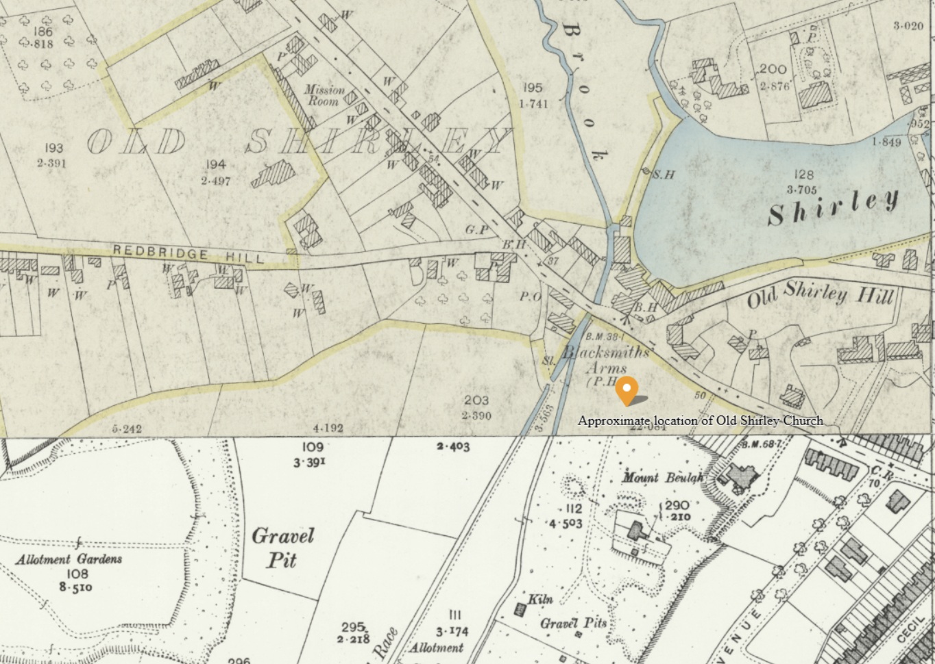
From the discussion on Facebook, this may be the location of the Old Shirley Church, which would have been demolished before 1282. It is a logical location based on the Old Shirley settlement of the map, and the streams and mill ponds.
Another Facebook entry,
Percy Road in Shirley, circa early 1900s, I think the modern day comparison location is about right. When the ground was cleared to build this housing development, a significant number of human remains were discovered. It’s believed the area was the graveyard for the original Shirley village church that was in that area.
An Heritage Gateway Entry
There was a church in Shirley at the time of the Domesday Survey (1086). In 1574, the parish church of Shirley was said to be rather small and in a state of ruin, and in that year the church and cemetery were annexed to Millbrook parish. The church was apparently pulled down in about 1609 and its materials used to enlarge Millbrook church. The location of the site of Shirley Church is uncertain as no locational details are given in the primary sources and it is not shown on any maps. Observations by Kell in the late 19th century (SOU 662) may have revealed part of the cemetery, although the location of Kell's observations is also unclear. Two locations for the church have been suggested. One location is the former Mount Beulah plot; an evaluation excavation on part of that plot in 1996 (SOU 742) failed to reveal evidence of either church or cemetery. The other location is the area now in the middle of the modern road junction of Winchester Road, Redbridge Hill, Romsey Road and Tebourba Way. Gravestones have been found on "Old Shirley Mill hill" although the location of this hill is uncertain.
[1], citing [2] and other sources: There was a church in Old Shirley at the time of the Domesday Survey (1086 IP), the advowson of which belonged to the lords of the manor of Shirley until 1233 when the advowson was granted to St Denis Priory. The church was subsequently appropriated to the Priory until the Dissolution when it fell into the King's hands. In 1549, Edward VI granted the rectory and tithes to Nich. Prideaux and the rectory and advowson thereafter occur in various hands until 1791.
[3]: In 1574 "The parish church . . . was in existence in far removed times as it now exists, rather small and in straitened circumstances." The tithe was less than £5. The church was owned by James Pagett. In 1574 the church and cemetery were annexed to Millbrook parish, reserving the rectory, glebelands and tithes to James Pagett etc. The church was in a state of ruin.
[4]: The church at Old Shirley is supposed to have been pulled down c1609 and its materials used to enlarge Millbrook church.
IP 24/3/1998: The location of the site of Shirley Church is uncertain. There are no locational details given in the primary sources and no maps show the site. Observations by Kell in the late 19th century (SOU 662) [6] may have revealed part of the cemetery; although the location of Kell's observations is also unclear they may have been located on part of the Mount Beulah plot (see related record for discussion). The OS Antiquity Card [5] locates the church on the Mount Beulah plot (grid reference SU 3937 1412). 18th and 19th century placename evidence ("Church Field" and "Church Close Litten" respectively) is linked in [5] to the Mount Beulah site. However an evaluation excavation (SOU 742) on the Mount Beulah plot failed to reveal evidence of the church or cemetery [8]. Gravestones have been found on "Old Shirley Mill hill" [4] although the location of this hill is uncertain. [7] suggests that Kell's observations, and hence the church and graveyard, were located on the level area now in the middle of the road junction of Romsey Road, Winchester Road, that is at approximately grid reference SU 3931 1423, although the case is not argued through. (See related records for details of all the above.)
HER 6/6/13: [9][10] are 20th century references, clearly to the find described in [6], although not giving source. [10] gives the date of the find as 1850.
Early Modern - 1540 to 1699
Early Modern - 1540 to 1699
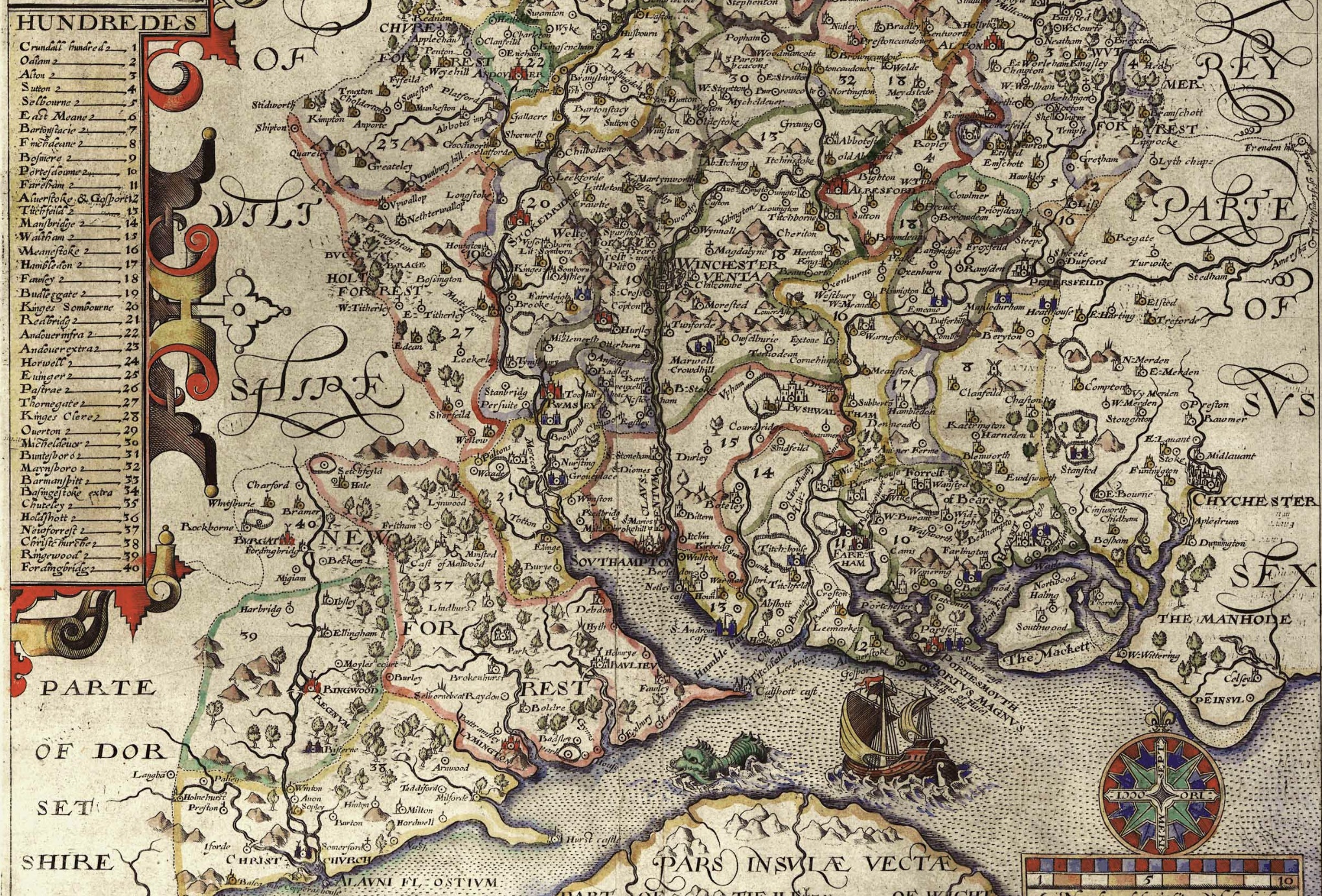
Norden's Map of Hampshire, 1607, extract of. Particluar interest it the Hundreds. In the Doomesday Book Millbrook, Shirley, and Redbridge, were all in the Hundred of Mansbridge (14). However, on the above Norden's Map of Hampshire, 1607, they were in the Hundred of Redbridge (21), and in respect of Millbrook in Waltham (15). From the key for Hundreds, there were a total of 40 named Hundreds. The settlements of Wimpson, Redbridge, Millbrook, and Hill, are shown on the map, but there is an absence of Shirley.
Slightly earlier, but included here for comparison.
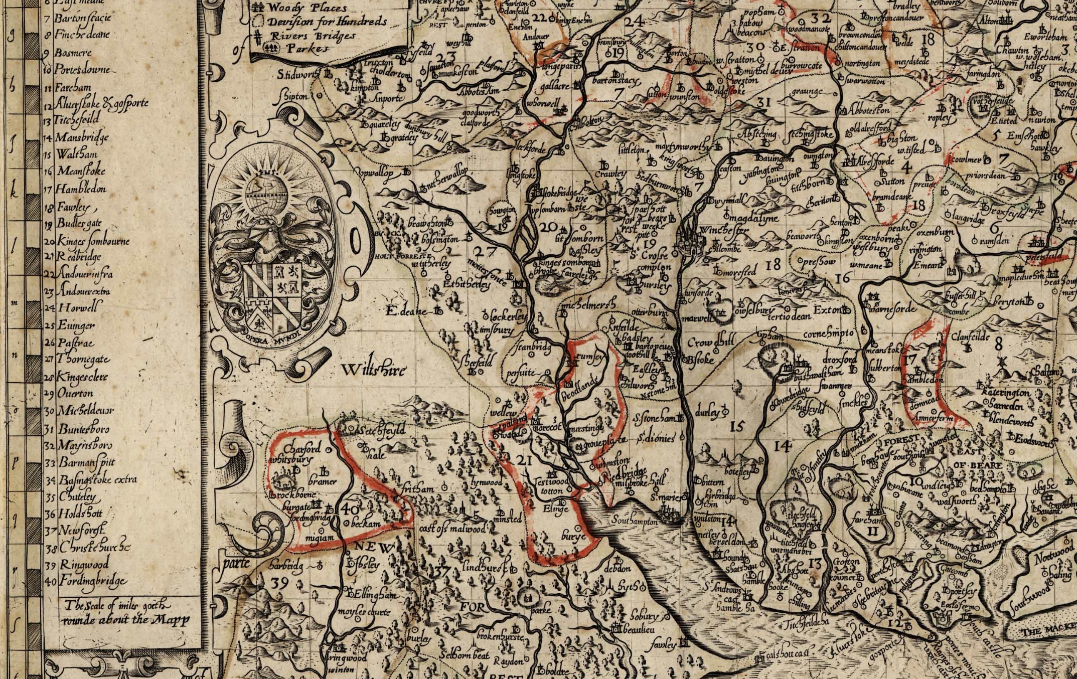
Extract of Norden's Map of Hampshire, 1595, Slightly earlier but similar with respect to Hundreds.
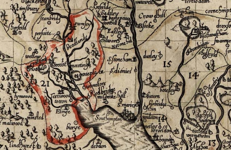
The same map but zoomed in. The boundary for the Hundred of Redbridge is marked in red. Not by me on this occasion.
The settlements of Wimpson, Redbridge, Millbrook, and Hill, are shown on the map, but there is an absence of Shirley.
Modern - 1700 to 1840
Modern - 1700 to 1840
Victorian - 1841 to 1901
Victorian - 1841 to 1901
Modern Administrative - 1902 to ongoing
Modern Administrative - 1902 to ongoing
Beginning of WWII 1939 to Absorption into Southampton 1952
Beginning of WWII 1939 to Absorption into Southampton 1952
.
The Records Section.
The next few sections are all about the available records, which don't necessarily fit to a timeline because of the time spread of the records, particularly the Census.
Tithe Apportionment and Map
Tithe Apportionment and Map

Tithe Apportionment - Parish of Millbrook, Hampshire
Note the reference to Depopulation and read more about it here. By 1530 the population of England and Wales had risen to around 3 million. At the end of the 17th century it was estimated the population of England and Wales was about 5 1/2 million. The population of Scotland was about 1 million. The population of London was about 600,000. London went on to become the biggest city in the world for a while. In the 19th century Britain became the world's first industrial society. It also became the first urban society. By 1851 more than half the population lived in towns. As our population approaches 70m it is interesting to think of depopulation efforts at 3 million! The maps of Millbrook clearly show the urbanisation of the countryside.
Following the Tithe Commutation Act 1836 Tithe Maps were produced which recorded both the Landowner and Occupier for most lands. From the Tithe Apportionments records it is apparent that on 4th March 1843 Lady Hewitt was both the Landowner and Occupier of Plot 875, Freemantle Estate, described as House Offices and Pleasure Grounds, with an area in statute measure 6,0,2, about 2.4 Hectares.
Nathaniel Newman Jefferys was both Landowner and Occupier of Plot 825 described as House Offices and Garden, an area of 2,2,24 imperial, on 4th March 1843. However, one plot does not show the full picture.
Using the Tithe Apportionment map of the Parish of Millbrook, Hampshire, as a base, I have colour washed some of the plot landowners. The Freemantle and Banister Estates, pale orange and brown respectively can be clearly seen. The landowners in 1843 where Lady Hewitt and Reverend William Fitzhugh. Shirley Park, owned by William Henry Roe, is in green. Blightmont Lodge, occupied by Lady Lisle, just north of Millbrook Road, and part of the larger Berrywood estate owned by Nathaniel Newman Jefferys is shown in a slightly darker blue than the light blue of the rest of the estate. It appears that Nathaniel Newman Jefferys has bought a large swath of the newly released Shirley Common land in the area of Shirley Warren. Clement Hoare & William Dunn seem to have also taken advantage of the inclosue of Shirley and Nutshalling Commons, as joint owners of plots coloured lime green. Roads such as Warren Avenue, Warren Crescent and Tremona Road have already been laid out for the impending urbanisation. However, the biggest landholding in the Parish, by a long way, is Sir John Barker Mill and various associates who together are landowners of the pink coloured plots, mainly farmland in 1843, but destined to be developed and absorbed as suburbs of Southampton.
Introduction and Conclusion
Introduction and Conclusion
Greenwood's Hampshire 1826 section 53
Moving into the current, the Church of England has a database of interesting statistics about all the Parishes in the country. Below is the Map which covers the original Millbrook Parish and shows the current Parishes of;
Millbrook: Holy Trinity
Freemantle: Christ Church (1851)
Shirley: St James (1836)
Maybush.
Click on the parish to bring up the statistics.
The Parish of Millbrook Tithe Map 1843 including Shirley, Freemantle and Four Posts, layered onto Google Earth Pro and Geolocated. Same base map as the coloured ownership map. Over 20 separate tiles or files to fit spherical base globe of Google Earth. All adjusted to best fit the projection, and align roads and as many details as possible. Below is just an image of the result. Google Earth Pro is desktop based so does not lend itself to sharing. However, using transparency of the layers I can locate buildings on the tithe map and see what is there now. I can also use the Lat and Lon and show on Google Maps to georeferenced individual buildings or plots.
The interactive version is created using a Project in Google Earth and can be seen here, The Parish of Millbrook Tithe Apportionment. Using the Tithe Map plotted on Google Earth Pro above and other maps, I have placed some of the Property names onto a Google Earth Project with an up to date backdrop. History mapped to now.
A screenshot as at March 2020. Work ongoing.
Notes
Notes
Extract from the British Newspaper Archive. Link to source but subscription required.
SOUTHAMPTON, Saturday, April 10. The Sale of Timber the New Inn, West JSr.d, by Air. C. Brooks, will not take place until Wednesday the 21st of April, 1830, instead of Thursday the 15th, as advertised in page 3. j N.B. good Dinner, Sfc. will be provided, gratis, and on the table at one o'clock. Married, on Thursday, at Eling, by tbe Rev. J. G. Phillips, MrThos.Couchman, coal merchant, to Ellen, eldest daughter of Capt. W. Gregson. Elm Lodge, Bursledon, formerly occupied by Mr Tyson, and since by Richard Trench, Esq. now fitting for a summer retreat by Wm. Moffat, Esq. ate of the firm of Williams and Co. bankers, Birchin-lane, London.—Col. F. Le Blanc has purchased Blackbrook House, between Fareham and Titehfield, and will shortly take up his permanent residence there. Several elegant villas are about to be erected on Shirley Common. Tht: overseers appointed for the parish of Eling, for tbe ensuing year, are—Jolin Taylor and John Anderson, Esqrs. Wm. Kimber, yeoman John Bull, coal merchant. Assistant overseer, J.Tiller.
Several elegant villas are about to be erected on Shirley Common.
Thought to be Plots 760 to 776 as shown on the Tithe Apportionment Map, in the Tithing of Hill and Sidford. Built on the Romsey Turnpike, later to become Shirley Road, the A3057. In the vicinity of the Rising Sun Public House, probably of the same date.
The Rising Sun public house in Shirley Road, now renamed The Brass Monkey. It opened in 1830, it's postal address was Shirley Common and it was a quiet country wayside inn. In this photo, it is called 'Rising Sun Hotel', J. Carter is the proprietor and Strong's of Romsey is the Brewery.
Transcription
Transcription
The Agreement is first transcribed into the Excel spreadsheet as part of the process of collating the data.
| APPORTIONMENT of the RENT-CHARGE in lieu of TITHES in the | Parish | of | Millbrook |
| in the | County | of | Southampton |
| Whereas an Agreement for COMMUTATION of TITHES in the | Parish | of | Millbrook |
| in the | County | of | Southampton |
| was, on the fourth Day of March in the Year One Thousand Eight Hundred and Forty three, | 4th March 1843 | ||
| confirmed by the Tithe Commissioners for England and Wales, of which Agreement, with the Schedules thereunto annexed, the following is a Copy :-- |
|
Articles of Agreement
|
| for the Commutation of the Tithes of the Parish of Millbrook in the County of Southampton in pursuance of the Act for the Commutation of Tithes in England and Wales made executed at a Meeting duly called and holden in the said Parish and adjourned from time to time and holden by Adjournment on the thirty first day of May in the year of our Lord One thousand eight hundred and forty two By and Between the Several Persons Owners of Land within the said Parish by whom or by whose Agents |
| duly authorised in that behalf these presents are executed and the interest of which Land Owners in the said Parish is not less than two thirds of the Lands therein subject to Tithes of the one part |
| The Reverend William Joseph George Phillips |
| who as Rector of the said Parish of the said Parish is Owner of a portion of the Tithes as well Great as Small thereof arising from forty six acres two roods and one perch of Titheable Lands which are setforth in the Second Schedule hereunder written and are |
| situate and being in the Tithing of Hill and Sidford in the said parish and |
| Sir Charles Henry Rich |
| now of Francfort on Maine Baronet Owner of another portion of the Tithes consisting of all the Tithes as well Great as Small arising from all the titheable lands in the said Tithing of Hill and Sidford excepting only all the Tithes of the before mentioned forty six acres two roods and one perch of land and also excepting all the Tithes as well as Great as Small arising from the Tithable lands of the said Tyithing of Hill and Sidford which are setforth in |
| the third fourth fitth and sixth Schedules hereunder written and are therein particularly described and |
| Sir John Barker Mill |
| of Mottisfont Abbey in the said County of Southampton Baronet Owner of the remaining portion of the Tithes as well great as small of the said parish consisting of all the Tithes arising from the titheable lands of the said Tything of Hill and Sidford which are setforth in the third fourth fifth and sixth Schedules hereunder written and are therein particularly described of the other part |
| Whereas |
| the said |
| Sir John Barker Mill |
| is seized in possession of an Estate for life with remainder to his Children in tail of all the Tithes of the lands ??? ??? particularly specified and described in the said third schedule hereunder written and is also seized in possession of an Estate for life with remainder to his children in tail of and in the said lands |
| Now |
| he the said |
| Sir John Barker Mill |
| Doth hereby declare it to his Will and Intent certified by his signature and seal hereunder annexed that the said Tithes as well great as small of the said lands shall henceforth be absolutely merged and extinguished in the freehold and inheritance of the said Lands. |
| It is |
| hereby agreed that the sum of Five hundred and fifty pounds by way of Rent Charge subject to the provisions of the said Acts shall be paid to the said |
| William Joseph George Phillips as Rector |
| of the said Parish and to his Successors instead of all the tithes as well great as small and all moduses and compositions real and prescriptive and customary payments payable to the said Rector in respect of the tithable lands of the said Parish or the produce thereof (except the customary payment of the sum of Five pounds hereinafter mentioned) and also including the tithe of Glebe the rent charge in lieu of which it is hereby agreed shall be fixed at the sum of six shillings in respect of all the tithes as well great as small of all the glebe lands of the said Parish which Glebe land belongs to the said |
| William Joseph George Phillips |
| and consists of three roods and thirty three perches and which item it is hereby agreed shall be apportioned exclusively upon the said Glede lands |
| And it is |
| hereby further agreed that the annual sum of Two hundred and fifty six pounds ten shillings by way of rent charge subject as afordsaid and also charged with the payment thereout of the entire provision or stipend amounting to the sum of Four pounds annually to the Rector of the said Parish for the time being which sum hash been customarily paid by the Lay Impropriator of the tithes of the Tythings of Hill and Sidfoord in the said Parish shall be paid to the said |
| Sir Charles Henry Rich |
| and his assigns during his life and after his decease to the person or persons who for the time being shall be entitled to the same instead of all those tithes of which the said |
| Sir Charles Henry Rich |
| is Owner as aforesaid and all Moduses and Compositions real and prescriptive and customary payments payable to him in respect of any of the titheable lands of the said Parish or the produce thereof |
| And it is |
| hereby further agreed that the annual sum of Thirteen pounds seven shillings and six pence by way of rent charge subject to the provisions of the said Act shall be paid to the said |
| Sir John Barker Mill |
| and his assigns during his life and after his decease to the person or persons who for the time being shall be entitled to the same instead of all those tithes as well great as small and all moduses and compositions real and prescriptive and customary payments payable to him or them in respect of the titheable lands of the said Parish or the produce thereof which lands are respectively set forth and particularly described in the said fourth fith and sixth schedules to those Presents |
| And it is |
| hereby lastly agreed that the lands of the said Parish shall be discharged from the payment of tithes as well great as small except as is excepted by the said Act from the first day of October which shall happen next before the Confirmation of the Apportionment of the said rent charges and that the first payment of such rent charges shall be made or be recoverable on the expiration of Six calendar months from the time from which the said lands are discharged from the payment of tithes |
| In testimony |
| whereof the said parties to these Presents or their respective Agents thereunto duly authorized in their names and on their behalf have to these Presents subscribed and set their respective hands and seals. |
| The |
| whole Parish of Millbrook aforesaid contains two thousand nine hundred and forty seven acres two roods and eighteen perches of land statute measure |
| The |
| whole of which lands except those lands the tithes arising from which are hereinafter declared be excepted are subject to the payment of tithe |
| The |
| whole quantity of land within the said Parish which is at present cultivated as arable land is One thousand five hundred and fifty seven acres and twenty six perches Statute Measure |
| The |
| whole quantity of land within the said Parish which is at present cultivated as meadow or pasture land is Six hundred and thirty acres two roods and thirty eight perches statute measure |
| The |
| whole quantity of land within the said Parish at present forming the sites of houses and roads and consisting of homesteads wood lands and commons or wastes is Four hundred and eight acres three roods and thirty three perches statute measure |
| The |
| under mentioned lands of the said Parish set forth in the first schedule to these Presents are exempt form the payment of all tithes as well Great as Small discharged therefrom by presumption of law |
Dataset
The Dataset
The dataset comprises all of the transcribed information from the Tithe Apportionment and Maps together with additional information, including, inter alia, geolocation and census data. All held in an Excel Spreadsheet. The data is both analysed within the spreadsheet and formed into reports for export as csv files to populate the StoryMap data.
Primary Data
Primary Data
Pending population
Detailed Data - Summary
Detailed Data - Summary
Pending population
Detailed Data - Landowner and Occupier Summary
Detailed Data - Landowner and Occupier Summary
Pending population
Detailed Data - Schedule
Detailed Data - Schedule
Pending population
Land Usage
Graph of Land Usage in Whiteparish in 1842 from the Tithe Apportionment information.
Analysis of the land usage based on the Tithe Apportionment information, showing the primary use as arable at 61%, and secondary usages of woodland 18% and pasture 16%. Common and Furze land has been reduced to about 1%, presumably as a result of the Inclosure Acts, (Enclosure).
Land Ownership
Graph of Land Ownership in Whiteparish in 1842 from the Tithe Apportionment information.
Land Ownership is more widely distributed than in some parishes that I have looked at.
Scroll right to see the list of landowners associated to the graph.
Plot register
The Table with all the data of the Detailed Plot register.
This table has the Landowners and Occupiers of all the Plots in the Parish, including the Description or Names of the plots together with the State of Cultivation. It instances where there is no entry, but it is evident what the Land Usage is I have added the category surrounded with { Brace Brackets }. Not relative to the Tithe Apportionment as some of the Land Usage is not part of the charge regime, however {Residence), {Premises} and {Retail} etc are useful additions. There are approximately 220 Mansions, Houses, or Cottages etc, across the Parish.
The areas of each plot together with the Rentcharge amount in respect of both the Small and Great Tithe, for the Vicar and Impropriator.
Top Ten Landowners
Top Ten Landowners in Whiteparish from the Tithe Apportionment information
From this analysis of the plot level detail for the Parish of Whiteparish the Top Ten Landowners own 91% of the whole recorded area of the parish. Two of the Landowners were relations to the Nelson of The Battle of Trafalgar fame.
Horatio Nelson, 3rd Earl Nelson, (7 August 1823 – 25 February 1913), was 16 years 9 months 7 days at the recorded data of the survey, 14th May 1840, a Minor, hence the Guardians of ...
He was the son of Thomas Bolton (a nephew of Vice Admiral The 1st Viscount Nelson) by his wife Frances Elizabeth Eyre. On 28 February 1835 his father inherited the title Earl Nelson from William Nelson, 1st Earl Nelson and adopted the surname of Nelson. He died on 1 November that year, and his son Horatio succeeded to the title and the estate, Trafalgar House in Wiltshire, in the nearby parish of Downton. The Eyre Family were the owners of Brickworth Park according to the Turnpike Acts for the Whiteparish Romsey Southampton Road. The Dowager Countess Frances Elizabeth Nelson was recorded as being the Landowner as Brickworth Park.
The remainder are either titled or referred to as Esquire. Although not all of the Esquires are in the top ten.
Spare
Spare
Pending population
Spare
Spare
Pending population
more later
Census
Your text...
1939 Register
Your text...
Other
People
People
People of note in the parish of Nursling, through time.
Your text...
Relatives
Relatives
Some of my relatives with an association to the parish of Millbrook.
Your text...
Spare
Your text...
more later