

Thomas Gilson
Relationship;- 2nd great-grandfather of wife.
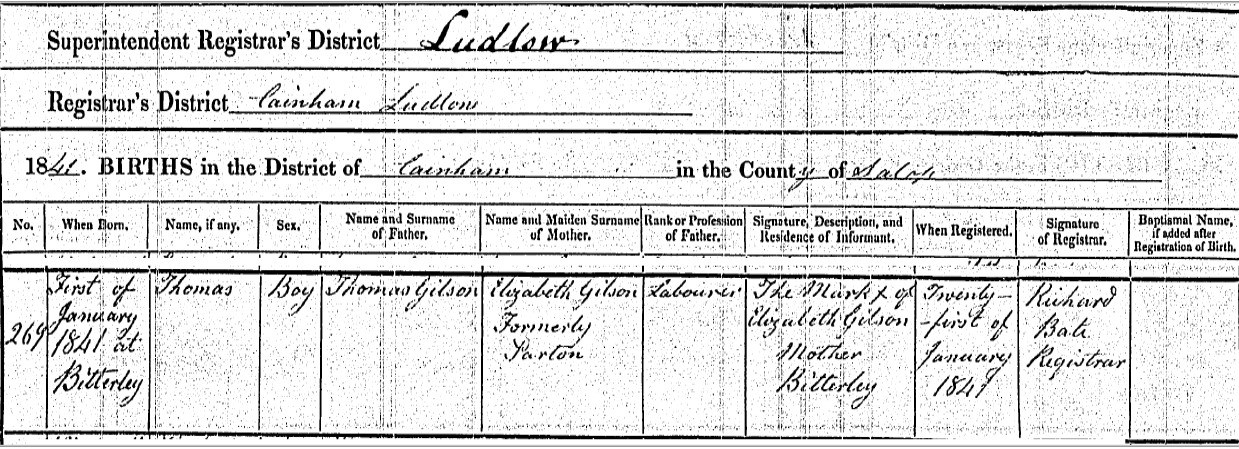
Thomas Gilson was born on 1st January 1841, in Bitterley, Shropshire, England according to his birth certificate. From subsequent information his birth could have been in Nine Springs Farm, Clee Hill, Bitterley, Shropshire, England.
The locations mentioned, Ludlow, Cainham, or Caynham, and Bitterley are all in the same area and are easily considered to be of increasing granularity.

On 24th January 1841 Thomas, son of Thomas and Elizabeth Gilson, whose recorded abode was Clee Hill, also near Bitterley, was baptised. His father's occupation is stated as Labourer.
 Shropshire LXXIX.3, Revised: 1902, Published: 1940 - NLS OS 25 Map Nine Springs Farm, Clee Hill, Bitterley, Ludlow
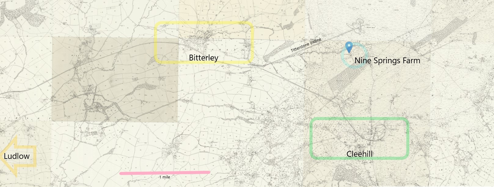
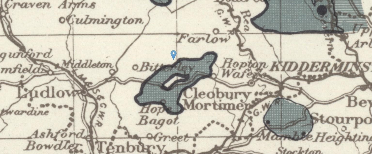
The same map as above but zoomed out to show the locational relationship between Nine Springs Farm, Cleehill, Bitterley, and Ludlow, just off the map. Walking distance between Nine Springs Farm and Cleehill is about 1 1/2 miles, about 30 minutes.
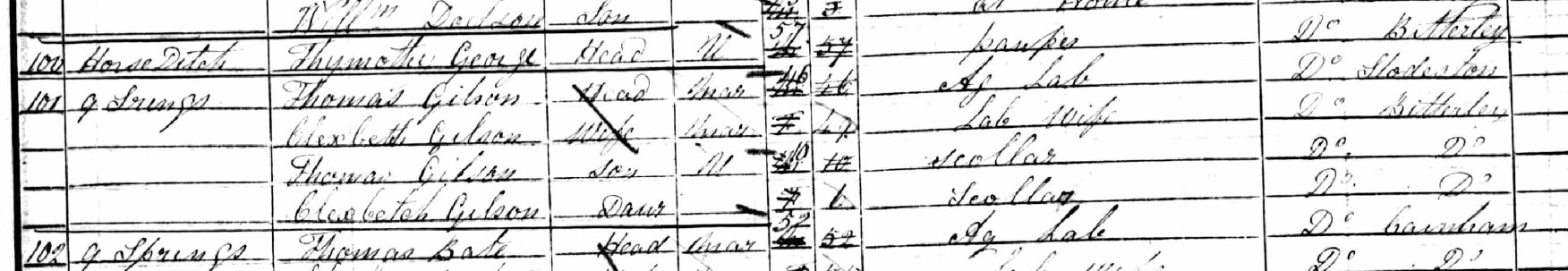
Below is an extract from the 1851 Census.
This is the reason for making the above assumptions about Nine Springs Farm, helped by the fact that it is still called that according to Google Maps. 9 Springs equates to Nine Springs Farm.
Thomas Gilson, aged 46, lived there with his family, Elizabeth, his wife, 49, son, Thomas, 10, and daughter, also Elizabeth, 1. Thomas Gilson, the head of the family is recorded as being an agricultural labourer. He was born in Stottesdon, about 9 miles to the NE, with the rest of the family having been born in Bitterley, all in the county of Shropshire, aka Salop.
Having found the 1851 Census, it is time to search for the 1841 Census record, which was found on FindmyPast.
The location of this record is Cottage, but on a nearby page is a reference to Nine Springs, with a Mr Thomas Bale, the same name as the 1851 Census. This could be explained by different enumerators recording in slightly different ways, with the 1841 one recording the various cottages associated with a farm as cottage, and the later one recording the cottages as part of the farm. Having said that there are twenty families with location Cottage, between Nine Springs and the Thomas Gilson record, and a further four families before the next location of Coldhampton. The next location was the village of Snitton.
Looking at the density of families between 1841 and 1851, it would appear as if a local employer had collapsed, leading to people moving away for alternative employment. A similar pattern appears to be the case for the Gilson. A large family, with 6 children in 1841, but only one of those left in 1851, and only one additional surviving child in the decade between Census.
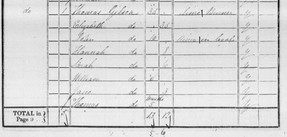
Thomas Gilson, aged 35 with his occupation being a Lime Burner. His wife, Elizabeth is stated as being 35, compared to 49 in the 1851 Census.
The oldest child listed is John, aged 10, already working as a Miner in Coal.
Hannah, 8, Sarah, 6, and Jane 3 are their daughters. Their other sons are William aged 5 years and Thomas, 5 months.
The 1841 census was taken on the night of 6 June 1841 and gave the total population as 18,553,124. Given that young Thomas was born on 1st January 1841, he was actually 6 months on the date of the Census.
Industries in the area.
There are a number of quarries and collieries in the area including;
- Titterstone Quarry, served by the Titterstone Incline. Coal, roadstone and dark “dhu stone,” a carboniferous dolerite.
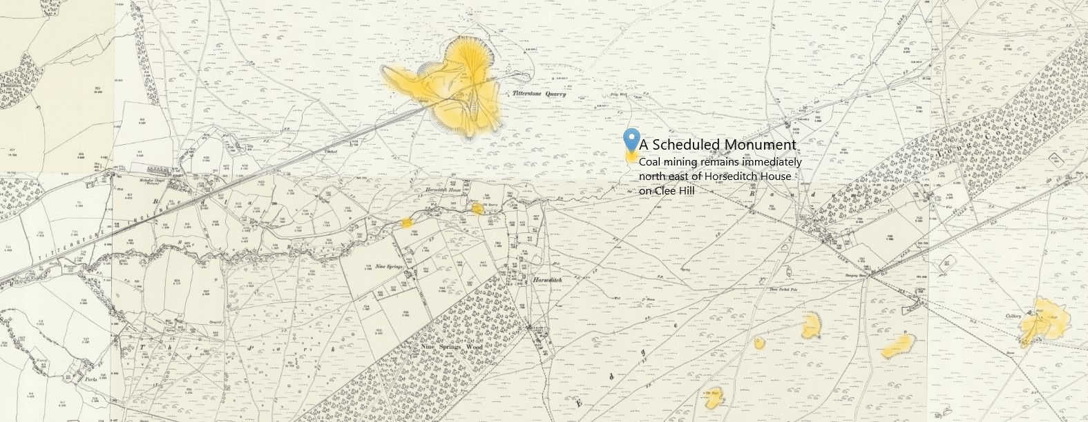
- Quarries and mines in the vicinity of Horseditch and Horseditch House, including coal.
- Old earthworks South of Hoar Edge.
- Colliery near Whatsill x 3
- Catherton Colliery near Magpie Hill, 1880 to 1914
- Quarries near Whatsill
- Cutley Colliery at Doddington
- Gibbet Colliery north of Shetfields
- Cornbrook Colliery near Cornbrook, 1880 to 1885
- Trout's Pit Colliery near Cornbrook, 1890 to 1895
- Quarries at Cornbrook
- Belfry Colliery near Cornbrook
- Cleehill Works, granite quarry
- Dhu Stone Quarries near Cleehill
- Old Furnace near Cleehill
- Old Limekilns, just south of Old Furnace
- Brickworks in the vicinity of the Old Furnace
The area is peppered with quarries and collieries with more opening after both the 1841 and 1851 Census.
The area around the Clee Hills, (a few miles east of Ludlow) is famous for its quarrying industry, which still works the very hard basaltic dhu-stone for road building. Brick making, iron working and coal mining were also once important to the local economy. In the 19th Century an iron furnace was built in Knowbury using the local iron ore, fired by local coal.
 NLS Old OS Map Land Utilisation Survey 1931 - 1938 - Clee Hill
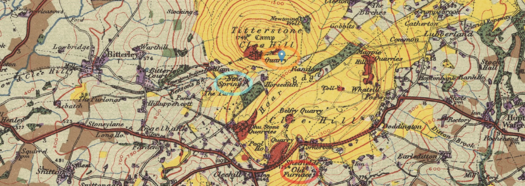
OS Land Utilisation Survey 1931 -1938 with Nine Springs circled in light blue, the aforesaid Acient Monument marked and circled in orange, and towards the bottom edge, an old Furnace, circled in red. There is a brickworks near the old Furnace according to another map. It is not necessirlarily where Thomas Gilson worked as a Lime Burner.
 NLS OS 10 Mile Coal and Iron Map 1945 ( based on 1940 report) - Clee Hill area
OS Map of Coal and Iron showing the coal fields in the vicinity of Nine Springs with the marker remaining at the Coal mining remains immediately north east of Horseditch House on Clee Hill, Bitterley, Shropshire (ancientmonuments.uk)